Models have been predicting snow all week but the biggest question we were waiting for confirmation on was; how much cold air actually makes it in and where does that put the snow line down to? Based on model updates late last night and into this morning, we are predicting colder air to filter in than originally anticipated with this storm meaning the snow line will move downward in elevation.
With that information, the NWS has upgraded Winter Storm Watches along the foothills to Warnings and issued new watches that include the rest of the Palmer Divide. Warning details, forecast updates and model guidance are all updated below.
Current Winter Weather Watches/Warnings/Advisories
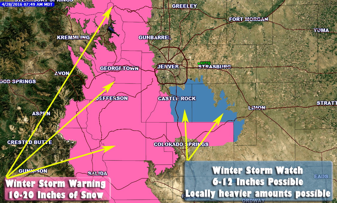
**Winter Storm Watch In Effect**
Timing
THE NATIONAL WEATHER SERVICE IN DENVER HAS ISSUED A WINTER STORM
WATCH...WHICH IS IN EFFECT FROM THIS EVENING THROUGH FRIDAY
EVENING.
Cities/Areas Included
CASTLE ROCK...ELBERT...FONDIS...KIOWA...
LARKSPUR
Snowfall
6 TO 12 INCHES ARE EXPECTED BY LATE FRIDAY
EVENING.
Impacts
ACCUMULATING SNOW ON BRANCHES AND POWER LINES COULD
LEAD TO TREE DAMAGE AND POWER OUTAGES. ROADS WILL GET SLUSHY OR
SNOW PACKED TONIGHT AND FRIDAY NIGHT. HOWEVER...DUE TO THE HIGH
SUN ANGLE DURING THE DAY ON FRIDAY HIGHWAYS MAY NOT EXPERIENCE
AS MUCH SNOW ACCUMULATION DURING THE DAYLIGHT HOURS.
A WINTER STORM WATCH MEANS THERE IS A POTENTIAL FOR SIGNIFICANT
SNOW...SLEET...OR ICE ACCUMULATIONS THAT MAY IMPACT TRAVEL.
CONTINUE TO MONITOR THE LATEST FORECASTS.
**Winter Storm Warning In Effect**
Timing
THE NATIONAL WEATHER SERVICE IN DENVER HAS ISSUED A WINTER STORM
WARNING FOR SNOW...WHICH IS IN EFFECT FROM 6 PM THIS EVENING TO
MIDNIGHT MDT FRIDAY NIGHT. THE WINTER STORM WATCH IS NO LONGER IN
EFFECT.
Cities/Areas Included
CAMERON PASS...
LARAMIE AND MEDICINE BOW MOUNTAINS...RABBIT EARS RANGE...
ROCKY MOUNTAIN NATIONAL PARK...WILLOW CREEK PASS...
BERTHOUD PASS...BRECKENRIDGE...EAST SLOPES MOSQUITO RANGE...
EAST SLOPES SOUTHERN GORE RANGE...EISENHOWER TUNNEL...
INDIAN PEAKS...KENOSHA MOUNTAINS...MOUNT EVANS...
WILLIAMS FORK MOUNTAINS...WINTER PARK...ESTES PARK...GLENDEVEY...
NEDERLAND...RED FEATHER LAKES...BAILEY...CENTRAL CITY...
EVERGREEN...GEORGETOWN...IDAHO SPRINGS...WESTCREEK...FAIRPLAY...
HARTSEL...LAKE GEORGE...SOUTH PARK
Snowfall
GENERALLY 10 TO 20 INCHES. FAVORED UPSLOPE
AREAS EAST OF THE CONTINENTAL DIVIDE WILL SEE THE MOST SNOW...
WITH TOTALS PERHAPS APPROACHING TWO FEET.
Impacts
ACCUMULATING SNOW ON BRANCHES AND POWER LINES COULD
LEAD TO TREE DAMAGE AND POWER OUTAGES. ROADS WILL AT LEAST GET
SLUSHY THURSDAY NIGHT AND FRIDAY NIGHT BUT DUE TO THE HIGH SUN
ANGLE DURING THE DAY ON FRIDAY THEY MAY NOT EXPERIENCE A LOT OF
ACCUMULATION DURING THE DAYLIGHT HOURS.
A WINTER STORM WARNING MEANS SIGNIFICANT AMOUNTS OF SNOW... SLEET
AND ICE ARE EXPECTED OR OCCURRING. TRAVEL IS LIKELY TO BE SEVERELY
IMPACTED.
Forecast
Expect a cool and cloudy Thursday with highs only reaching the mid 40's in Castle Rock and most places along the Palmer Divide. Rain tonight will transition into snow through early Friday morning. Friday looks to be the biggest impact day, snow will continue and accumulate all day into Friday night and possibly early Saturday morning.
Area Snowfall Amounts
-
Castle Rock: 8-12 inches
-
Palmer Divide South (Larkspur, Monument…) : 10-20 inches
-
Western Douglas County Foothills: Spots of 10-20 inches
-
Denver: 3-6 inches
Timing
-
Rain showers will begin Thursday and last on and off through the day.
-
Rain will transition into snow later on Thursday
-
By Thursday night into Friday snow will fall and begin to accumulate
-
Best chances of snow is late Thursday, all day Friday and into Saturday morning. Lighter snow will linger on Saturday – Sunday
-
Impacts
-
Heavy snow will stress budding or trees with leaves on them. Keep an eye on those branches and be prepared to shake them off frequently to prevent damage
-
Heavy snow may accumulate on power lines causing power outages in areas
-
Road conditions may get slushy and snow-packed in some areas. Due to the warmer daytime temperatures and higher angle of sunlight, travel may become tricky in some areas but not all areas will see bad road conditions.
-
Latest Model Guidance
 |
GFS (Long Range Model)Storm Total Accumulation by Saturday April 30, 2016 6:00PM The GFS agrees on snowfall with colder air filtering Using 10:1 Ratio: 10-12 inches of snow |
 |
NAM (Medium Range Model)Storm Total Accumulation by Saturday April 30, 2016 6:00PM The NAM shows slightly lesser accumulation than Using 10:1 Ratio: 8-10 inches of snow |
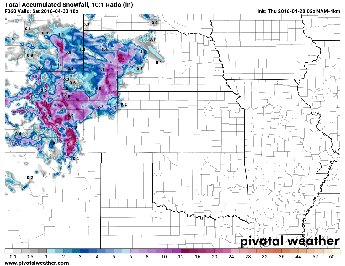 |
NAM4K (Short-Medium Range High Resolution Model)Storm Total Accumulation by Saturday April 30, 2016 12:00PM The NAM 4K's range doesn't quite encompass Using 10:1 Ratio: 9-12 inches of snow |
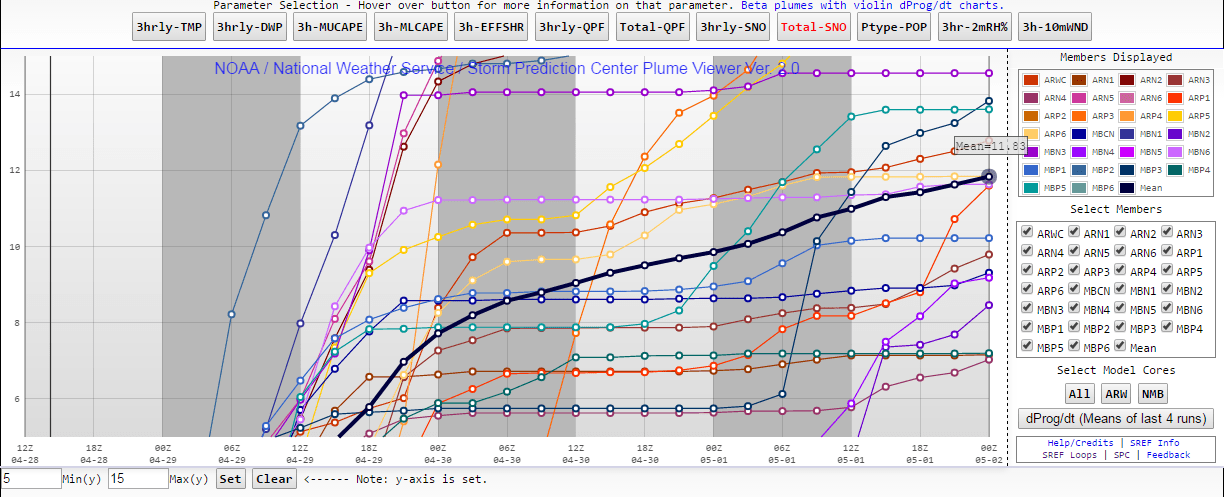 |
SREF Ensemble (Short Range Model Ensemble)Storm Total Accumulation by Saturday April 30, 2016 12:00PM The SREF is a combination of a bunch of model The SREF Ensemble has been slowly |
**Please note, the snowfall forecast ranges are looking at data for the Castle Rock area.
Summary
This spring storm is loaded with moisture and just like the last, temperatures will play a huge part on how much snowfall accumulates. The biggest impact to travel looks to be Friday and possibly Saturday morning, so keep that in mind if you are commuting in on Friday or out and about on Saturday.
This storm will not trap you in your house for days, so I honestly don't think a grocery store run is necessary as long as you have food for Friday and Saturday. Most likely, roads will be slushy but passable and clearing on Saturday by late morning.
I will be keeping a close eye on that watch area and will relay any information in forecast change or warning upgrades throughout the day today. Stay tuned!


Thanks for the ipdate