Friday looks to feature our last warm day for at least a little while. A strong cold front will move through the area this afternoon and looks to bring cooler temperatures into the front range until at least mid-next week. This storm system doesn't look to bring a particularly large amount of moisture to most of us sadly so it doesn't look like we'll make too much of a dent in this abnormally dry September we are working our way through. Here's the latest:
Colorado Weather Watches/Warnings/Advisories for September 23, 2016
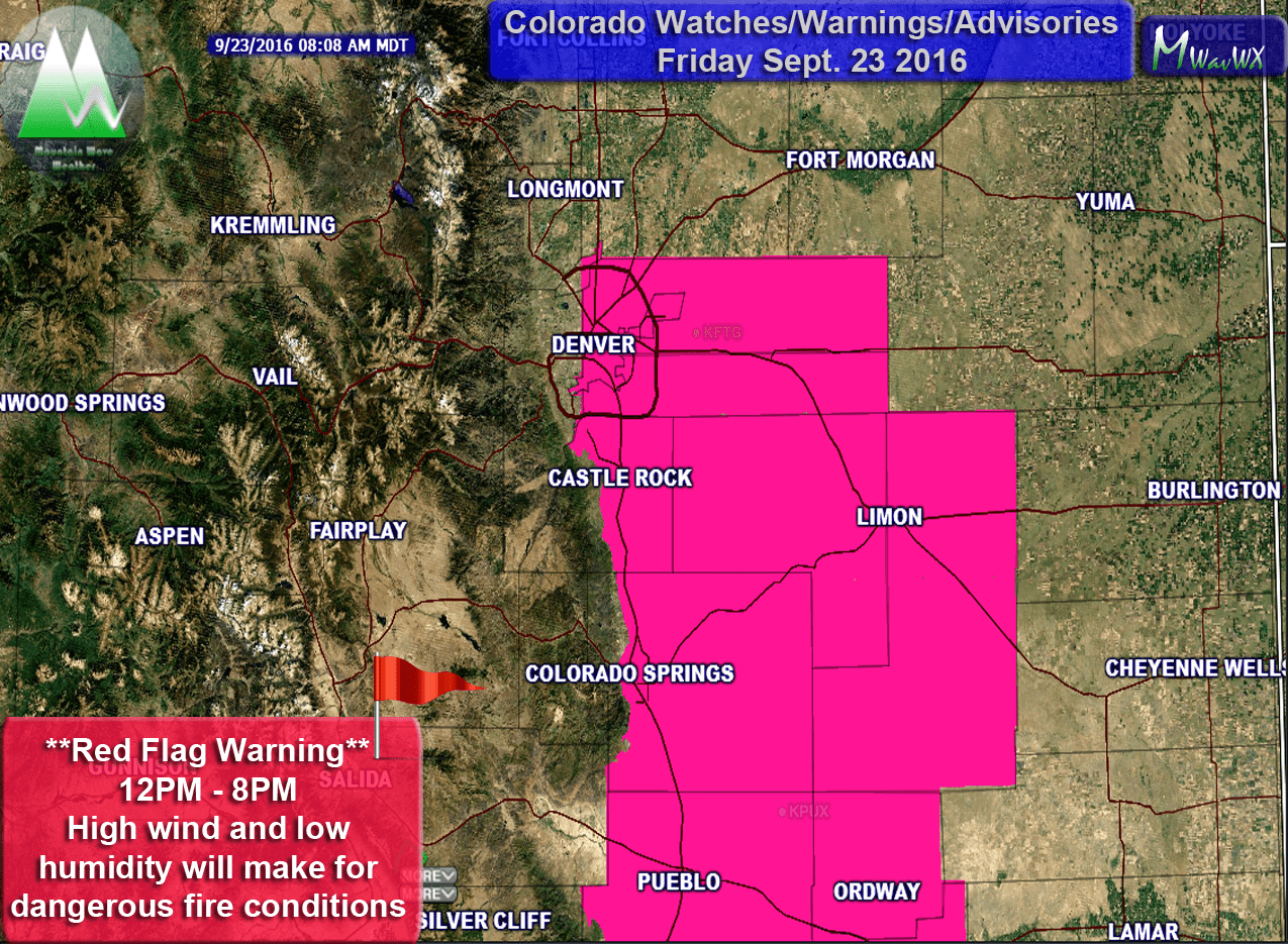
Red Flag Warning in affect today
A Red Flag Warning goes into affect from 12PM until 8PM tonight for areas along the front range and to the East. This is most likely due to the cold front that is scheduled to move through the area this afternoon. In advance of the front, humidity will drop and winds will pick up quite a bit, those conditions combined with the dry weather we have experienced lately will make for dangerous fire conditions. Any fires that start will have the potential to spread quickly.
Castle Rock/ Colorado Weekend Forecast
Castle Rock
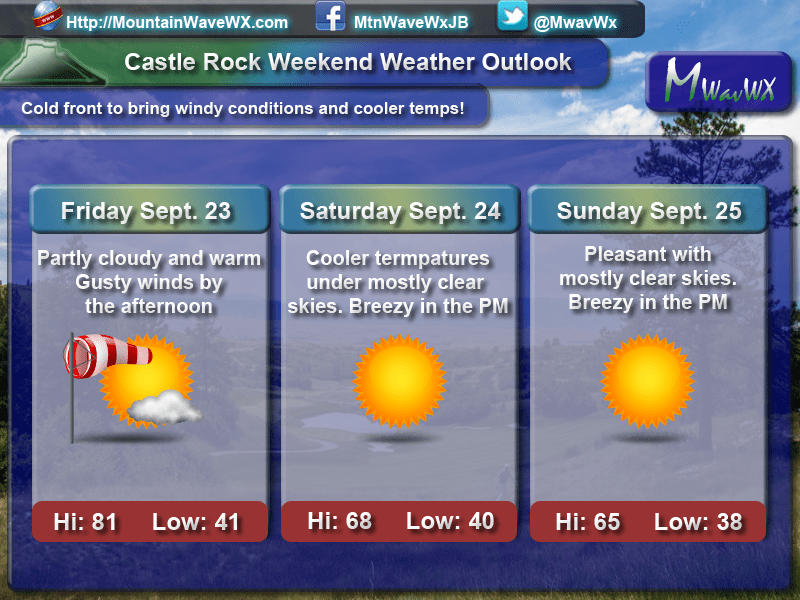
Windy and warm on Friday, cooler by the weekend. Overall nice though!
A Look at Other Regions in Colorado
For those of you outside the Castle Rock/ Palmer Divide area with weekend plans, here’s a quick look at what to expect:
- Fort Morgan Area
- Friday: 89/45 – Partly cloudy and warm, strong winds possible after 12PM with temperatures dropping quickly after 6PM. A slight chance of thunderstorms exists (20% chance)
- Saturday :76/41 – Mainly sunny and cooler. Breezy conditions may develop in the afternoon hours
- Sunday: 71/38 – Mostly clear and cool, a slight breeze may develop in the afternoon hours
- Limon
- Friday: 84/40 –Partly cloudy and warm, strong winds possible after 12PM with temperatures dropping quickly after 6PM. A slight chance of thunderstorms exists (20% chance)
- Saturday :73/40 – Mostly sunny through the day and cooler with breezy conditions possible in the evening hours
- Sunday: 67/37 – Sunny and cool with breezy conditions in the afternoon hours
- Winter Park/Fraser
- Friday: 60/33 – Partly cloudy and cool during the morning hours. A decent chance of thunderstorms exists in the afternoon hours (60% chance)
- Saturday: 51/32 – Mostly cloudy and cool, a slight chance for thunderstorms in the afternoon hours (20% chance)
- Sunday: 59/32 –Partly cloudy and cool to start the day with skies clearing in the afternonon hours
- Woodland Park
- Friday: 66/34 – Partly cloudy in the morning with gusty winds developing by afternoon. There is a slight chance for thunderstorms later in the day (20% chance)
- Saturday: 60/33 – Clear skies with cooler temperatures, possibly a bit breezy in the afternoon
- Sunday: 57/36 – Partly cloudy conditions with a slight breeze in the afternoon
This Weekend's Weather Setup
The main story of the next few days will be the arrival of a strong cold front on Friday afternoon. Many models show the first effects of this system to start showing up after about 12PM. The initial effects will be a shift in wind direction, strong gusty winds and dropping humidity.
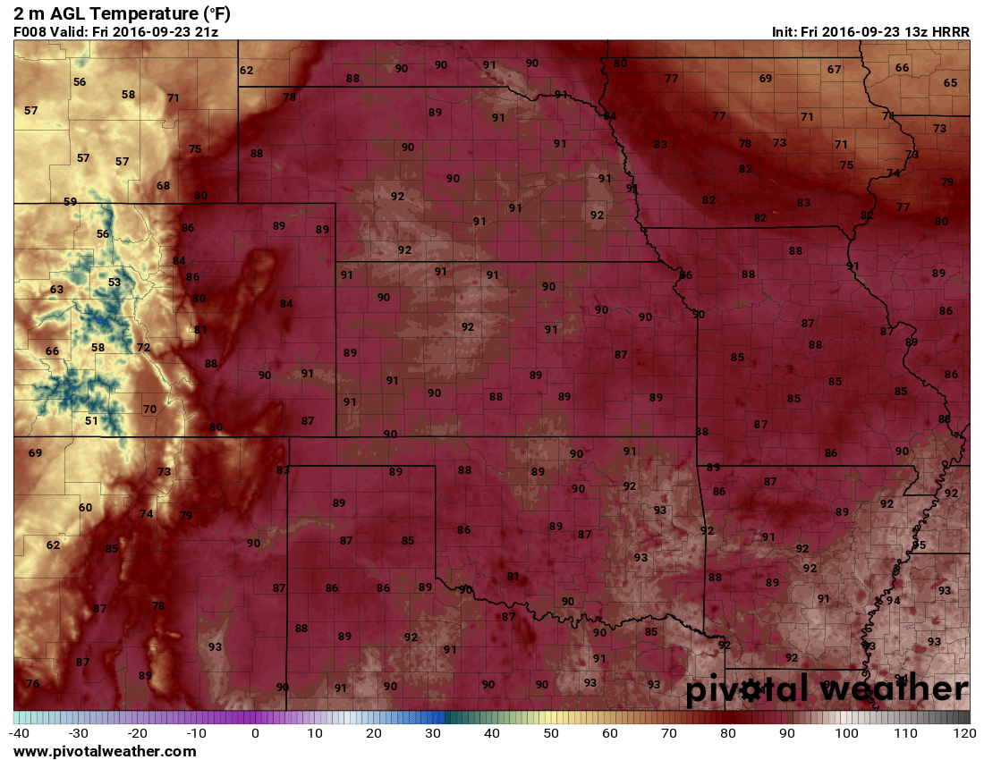
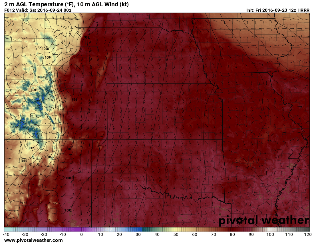
3PM look at the HRRR Model. Notice the colder air moving into the western part of the state and through Wyoming...
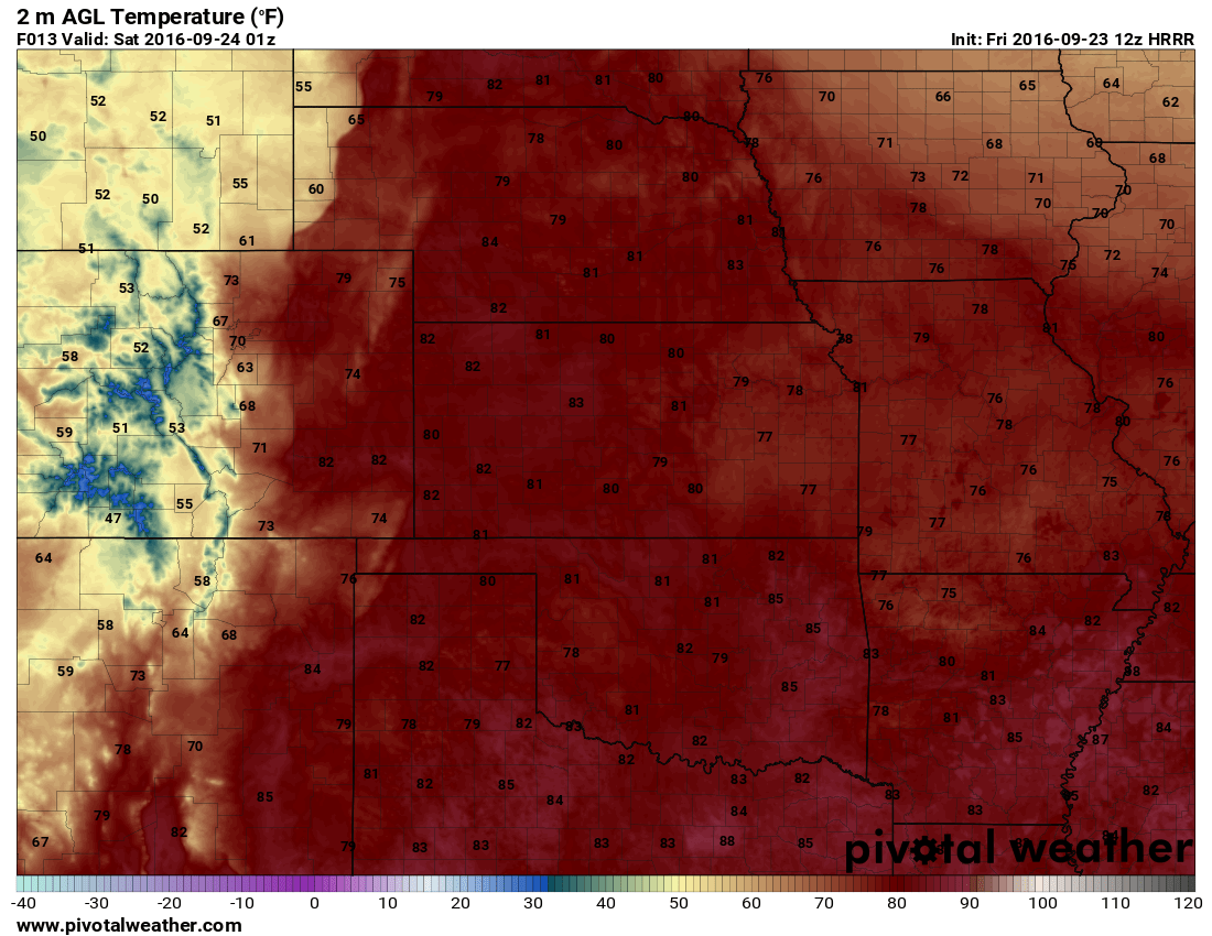
7PM look at the HRRR Model. The cooler air begins to take hold along the front range into the evening hours
By the evening hours the cooler air begins to move in along the front range. The front can clearly be seen on the models with a sharp dividing line between the warmer and cold air.
HRRR wind forecast at 6PM
In advance of and with the passage of the front, many models pick up on strong South/Southwesterly winds in the magnitude of 20-30knots (25-35mph)
Unfortunately, the center of this storm system (the low pressure center) looks to move too far North to bring most of us along the front range any decent moisture. While we see a small chance of a storm today (20% or so) along the front range, most modelling keeps the bigger storms with heavier rain into the mountains and further out on the Eastern plains.
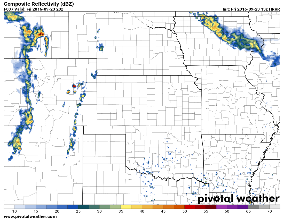
HRRR composite reflectivity (forecast radar for thunderstorms and rain)
Summary
In short, expect a warm and windy Friday for most of us East of the divide. Saturday and Sunday look to be sunny with pleasant temperatures in the 60's but the nights will be borderline chilly. Some areas may be in the mid to upper 30's by Saturday and Sunday morning.
Sadly, not a lot of rain expected out of this at this time. We will keep an eye on the models and forward any info along if the forecast changes. Have a great weekend!

