Lots to talk about with this storm and some new warnings have been issued with this storm that people need to know about. This is a bit of a lond upgate but there's a ton of important information.
Latest Weather Watches and Warnings
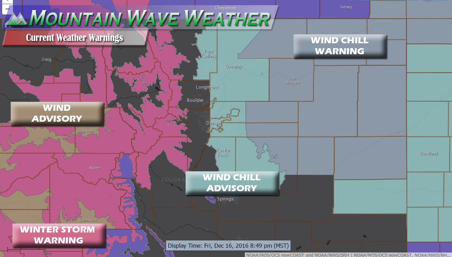
Here's the rundown:
- Winter Storm Warning
- For:
CAMERON PASS,
LARAMIE AND MEDICINE BOW MOUNTAINS, RABBIT EARS RANGE,
ROCKY MOUNTAIN NATIONAL PARK, WILLOW CREEK PASS, BERTHOUD PASS,
BRECKENRIDGE, EAST SLOPES MOSQUITO RANGE,
EAST SLOPES SOUTHERN GORE RANGE, EISENHOWER TUNNEL, INDIAN PEAKS,
KENOSHA MOUNTAINS, MOUNT EVANS, WILLIAMS FORK MOUNTAINS,
AND WINTER PARK
- Duration:
REMAINS IN EFFECT UNTIL 11 AM MST
SATURDAY
- Impacts:
* SNOW ACCUMULATIONS...8 TO 16 INCHES.

* WIND/VISIBILITY...WEST TO SOUTHWEST WINDS OF 20 TO 35 MPH WITH
  GUSTS AROUND 50 MPH WILL PRODUCE BLOWING SNOW OVER THE HIGHER
  PASSES AND RIDGES THROUGH FRIDAY NIGHT. VISIBILITIES MAY FALL
  BELOW A FEW HUNDRED FEET AT TIMES IN HEAVY SNOWFALL AND
  BLOWING SNOW.

* IMPACTS...THE SNOW AND BLOWING SNOW WILL PRODUCE HAZARDOUS AND
  VERY DIFFICULT TRAVEL CONDITIONS ACROSS THE MOUNTAINS TODAY
  THROUGH SATURDAY MORNING. TRAVEL RESTRICTIONS AND ROAD
  CLOSURES ARE HIGHLY POSSIBLE.
- For:
- Wind Advisory
- For:
GRAND JUNCTION...FRUITA...PALISADE...
DE BEQUE...NEW CASTLE...MESA...PARACHUTE...RIFLE...SILT...EAGLE...
EDWARDS...GLENWOOD SPRINGS...CARBONDALE...MONTROSE...HOTCHKISS...
DELTA...GUNNISON...CIMARRON...GATEWAY...NUCLA
- Duration:
UNTIL 11 PM MST THIS EVENING
- Impacts:
* WINDS...SOUTHWEST 20 TO 30 MPH WITH GUSTS UP TO 50 MPH.

* IMPACTS...DRIVING WILL BE DIFFICULT ESPECIALLY FOR HIGH
  PROFILE VEHICLES. LOOSE OUTDOOR OBJECTS MAY BE TOSSED AROUND
  IF NOT PROPERLY SECURED.
- For:
- Wind Chill Advisory
- For:
FORT COLLINS, HEREFORD, LOVELAND, NUNN,
AURORA, BRIGHTON, CITY OF DENVER, DENVER INTERNATIONAL AIRPORT,
HIGHLANDS RANCH, LITTLETON, PARKER, CASTLE ROCK, ELBERT, FONDIS,
KIOWA, LARKSPUR, EATON, FORT LUPTON, GREELEY, AND ROGGEN
-
Duration: FROM 5 AM TO NOON MST SATURDAY FOR THE URBAN CORRIDOR - Impacts:
* WIND CHILL VALUES...15 TO 25 BELOW ZERO.

* IMPACTS...THE COLD TEMPERATURES AND WINDS WILL PRODUCE
  DANGEROUS WIND CHILL TEMPERATURES WITH POSSIBLE HYPOTHERMIA
  CONDITIONS WITH EXPOSED SKIN.

PRECAUTIONARY/PREPAREDNESS ACTIONS...

A WIND CHILL ADVISORY MEANS THAT VERY COLD AIR AND STRONG WINDS
WILL COMBINE TO GENERATE LOW WIND CHILLS. THIS WILL RESULT IN
FROST BITE AND LEAD TO HYPOTHERMIA IF PRECAUTIONS ARE NOT TAKEN.
IF YOU MUST VENTURE OUTDOORS...MAKE SURE YOU WEAR A HAT AND
GLOVES.
- For:
- Wind Chill Warning
- For:
NORTHEAST WELD COUNTY-MORGAN COUNTY-
CENTRAL AND EAST ADAMS AND ARAPAHOE COUNTIES-
NORTH AND NORTHEAST ELBERT COUNTY BELOW 6000 FEET/NORTH LINCOLN
COUNTY-LOGAN COUNTY-WASHINGTON COUNTY-SEDGWICK COUNTY-
PHILLIPS COUNTY-
- Duration:
...WIND CHILL WARNING REMAINS IN EFFECT FROM 5 AM TO NOON MST
SATURDAY...
- Impacts:
* WIND CHILL VALUES FOR THE ADVISORY WILL RANGE FROM 15 TO 25
  BELOW ZERO. WIND CHILL VALUES WILL DROP BELOW 25 DEGREES BELOW
  ZERO FROM 5 AM UNTIL NOON SATURDAY.

* IMPACTS...THE COLD TEMPERATURES AND WINDS WILL PRODUCE
  DANGEROUS WIND CHILL TEMPERATURES WITH POSSIBLE HYPOTHERMIA
  CONDITIONS WITH EXPOSED SKIN.

PRECAUTIONARY/PREPAREDNESS ACTIONS...

A WIND CHILL WARNING MEANS THE COMBINATION OF VERY COLD AIR AND
STRONG WINDS WILL CREATE DANGEROUSLY LOW WIND CHILL VALUES. THIS
WILL RESULT IN FROST BITE AND LEAD TO HYPOTHERMIA OR DEATH IF
PRECAUTIONS ARE NOT TAKEN.
- For:
See all Castle Rock specific Watches/Warnings/Advisories on our Weather Warnings Page
Snow Has Moved Into The Area
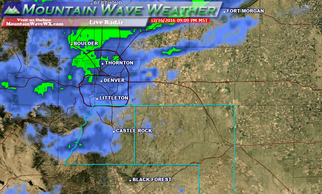
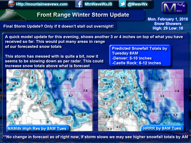
Most models have remained on track with regards to snow this evening. The HRRR model (which called the last couple of storms quite well) shows the Castle Rock area generally in the 2-4 inch range we have been going with since yesterday.
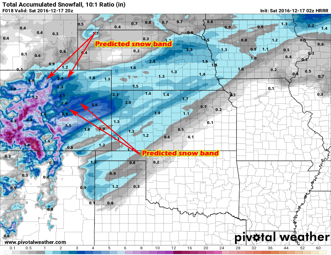
There is a big but with this model run; while it shows banding of snow most models have trouble predicting exactly where these set up. Any areas under the narrow bands of heavy snow could end up seeing way more than predicted. This makes the snowfall forecast very tricky for us but this is what we have so far.
Castle Rock Area Predicted Total Snowfall Accumulation through Saturday PM
2-4 inches -- if we end up under a stronger snow band we could see something more in the 4-8 inch range!
We are generally sticking with the 2-4 inch range for now in Castle Rock butare concerned about higher totals if the town gets stuck under a heavy snow band. We will keep an eye on it.
Extreme Cold
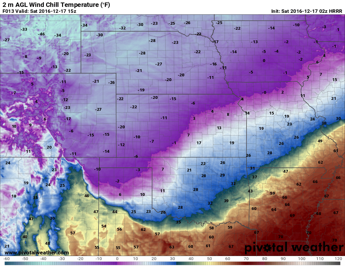
Please understand that these types of wind chills ARE DANGEROUS. If you are trapped outside without proper clothing for a period of time, you can get frost bite or hypothermia. If you must venture outside, be prepared.
Please bring your pets inside tonight, these are dangerous conditions for them as well, no matter the breed!
Wind chill values are expected to be in the -10 to -30 range across the front range of Colorado by Saturday morning. The above image is for around 8AM Saturday morning and shows values in and around Castle Rock as low as -23.
Impacts
- Snow will stick to the roads quickly and make travel difficult. We are already seeing evidence of this at the time of this posting.
- Flash Freezing is possible for some roadways, this will make travel dangerous
- By Saturday morning the temperatures will the the biggest issue. Wind chill values will mean prolonged exposure could result in frost bite and hypothermia.
More data is coming in with this storm, we will continue tracking it and have further updates if needed.


Trackbacks/Pingbacks