A statistical look and discussion of weather recorded for Castle Rock Colorado. This information was collected and recorded via my weather station in the Meadows in the town of Castle Rock. It is in no way an “official” record, just simply what was recorded by my station.


Summary
There were some concerns about our strong El Nino pattern breaking down too quickly through March and all but eliminating our chances for a wet spring. March and now April 2016 delivered in a big way for moisture in Colorado and much of it in snowfall. Normally we see higher than average temperatures in an El Nino spring accompanying the higher than average precipitation, but April 2016 was the second month in a row with below average temperatures and well above average snowfall.
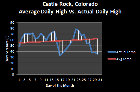
First we look at the temperatures. I saw a lot of similarities between March and April 2016. The front half of the month started out relatively warm and quiet while the second half of the month saw much below average temperatures as a series of storm systems moved through.
This helped April 2016 finish 1.07 degrees below average when combining daytime and nighttime temperatures (daily mean)
As is often the case in El Nino spring months, it was very, very soggy! The colder temperatures (again this was unusual for an El Nino spring month) ensured that a large amount of the snow that fell came down as snow.
In fact, April 2016 finished way above average in terms of snowfall.
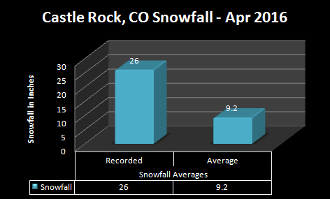
April is our third snowiest month and one of the wettest months of the entire year. It is not uncommon to see April's with large amounts of snowfall. April 2016 finished a staggering 16.8 inches over the normal monthly average for snowfall! To say it was a snowy month is an understatement but surprisingly didn't crack one of the top snowiest Aprils in history. This was a snowy April, but we have had much snowier April's in the past!
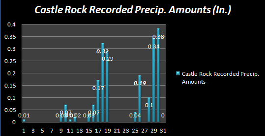
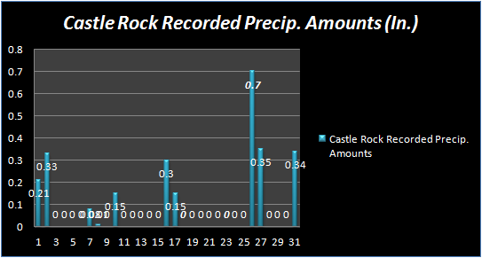
As if we needed any more proof of how soggy April was, here's a look at collected precipitation and days they were collected. You can see we saw big numbers in the second half of the month pretty consistently.
Speaking of which, this year Castle Rock has seen a large amount of snow!
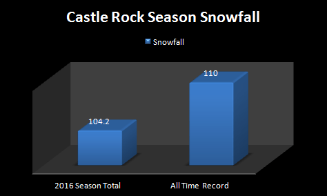
The city is only one good storm or maybe 2 smaller storms from seeing the most snowfall recorded in a single season in history. The previous amount was set in the early 80's (folks who've been here awhile will remember the infamous 1982-1983 season accompanied by the Christmas Blizzard of '82!) I took a look at a lot of stations along the Palmer Divide and foothills and many locations are very close to breaking their snowfall record too. Will we make it? Time will tell!
May 2016 Outlook
The CPC predicts a better chance of cooler and wetter than average weather through the month of May.
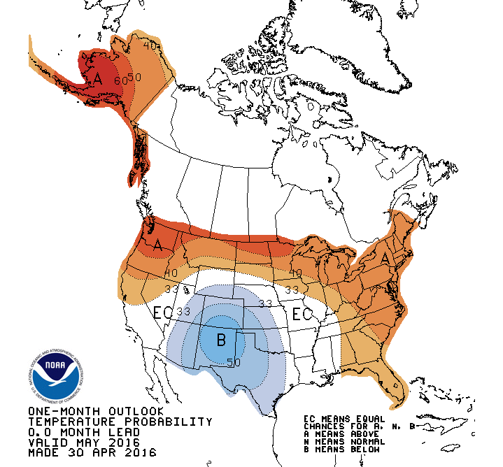
Given the "troughiness" of the weather pattern (lots of storms projected to move through, generally every week or week and half or so) I can definitely see this being the case. Although I would consider this unusual to what we normally see in May during an El Nino year. I took a quick look at the GFS going out a ways and saw that while we do get some decently warm days here and there, every week or so a big storm system moves through and cools things back down. I saw no indication of strong ridges building in the first half of May, meaning temps will most likely be at or below average the first part of the month.
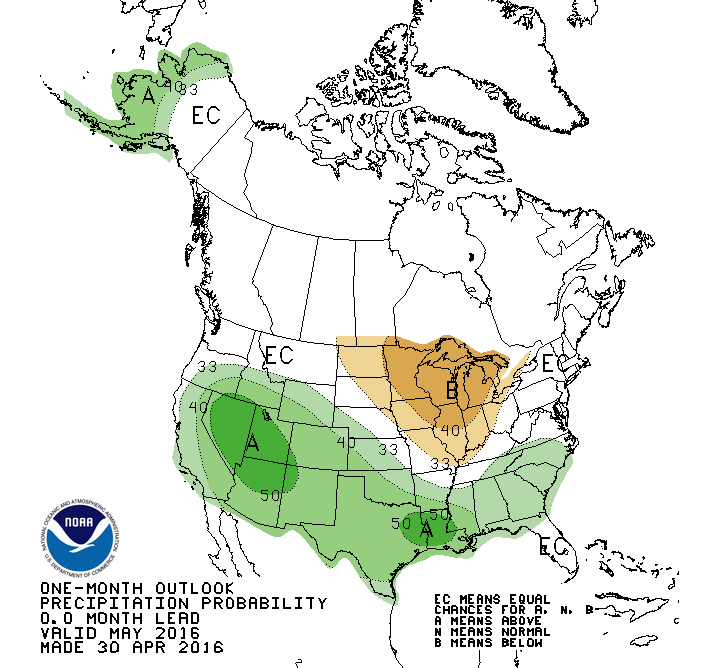
The precipitation outlooks coincides quite well with what we are predicting above. Troughs continually moving out of the West (either Northwest or Southwest) will most likely mean we see at least a few soggy, mulit-day storm systems through the month of May.
In short, expect temperatures in May 2016 to be at or below average and precipitation to be slightly above average overall.

Summary
May 2016 was another month where we saw common characteristics of El Nino and some not so common characteristics. We expect to have wetter than average months in a spring with an established El Nino pattern and May 2016 did not disappoint in that aspect. We did however see another month of below average temperatures which is somewhat unusual for an El Nino month but I have a theory behind this that I'll explain a bit in the section below.
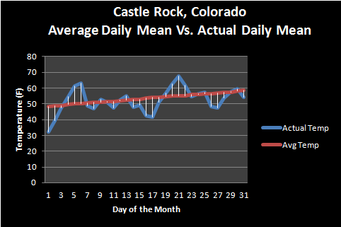
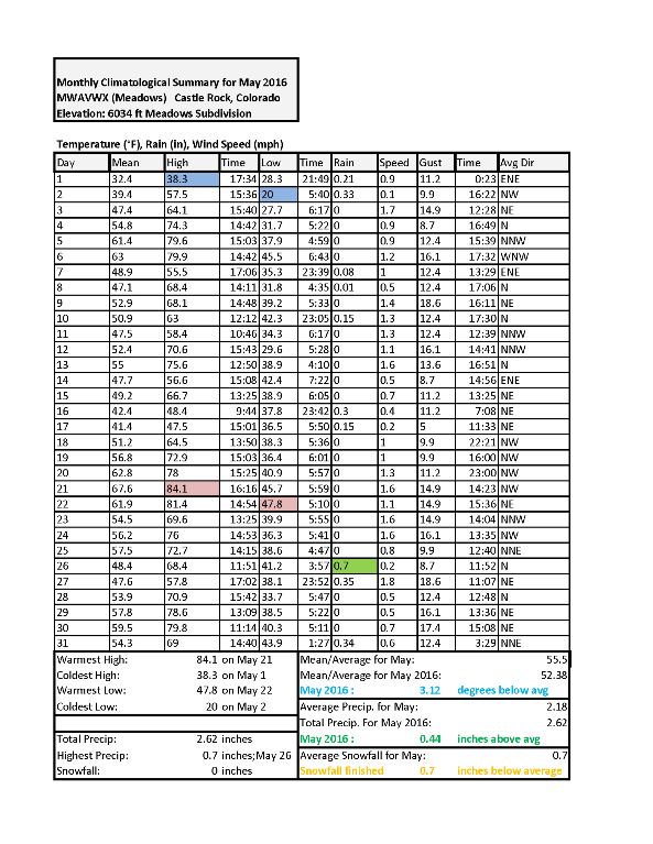
I am now collecting temperature data for the average or daily mean temperature. This reflects an overall better picture on temperatures for our area as it averages the daytime and nighttime temperatures. I will probably be updating all the 2016 months with this temperature data eventually.
For May 2016, you can see two bumps of above average temperatures but other than that, temperatures remained at or below normal. This verifies the colder than average overall temperature for Castle Rock during the month. A lot of the below average temperature had to do with the amount of storm systems we had visiting the state on a nearly weekly basis. More clouds and lots of moisture means we'd expect our temperatures to stay cool.
We can see above the amount of precipitation collected and on what days. No snow was recorded during May 2016 so this all fell as rain. You can see how closely it mirrors the temperature graph above. Overall May 2016 finished wetter than average, again this is to be expected during an El Nino spring month.
June 2016 Outlook (And a Note About El Nino)
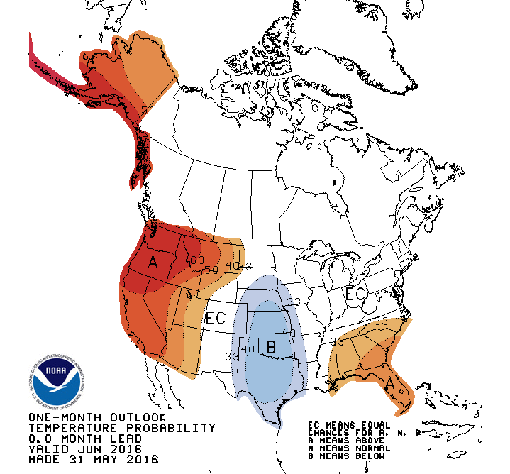
June 2016 Probability of Above or Below Normal Temperatures
The Temperature outlook for June 2016 from the Climate Prediction Center shows equal chances for above or below average temperatures for most of Colorado. Notice the reds to our west and the blues to our East, we look to be caught right in the middle of a series of weather patterns. Basically this is the CPC's way of saying "it could go either way." Personally, I believe a weakening El Nino coupled with our typical late June dryness; I would expect temperatures to be right around to slightly above average.
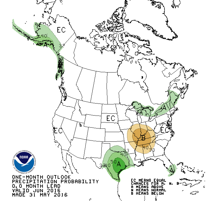
June 2016 CPC probability of above or below average precipitation
The precipitation situation for June 2016 I think, is going to be very difficult to forecast. When I looked at some of the mid-long range models I saw a very pronounced ridge in the upper atmosphere through at least June 20. This means larger and colder storm systems will have trouble moving into the state, thus why I believe we may finish with a warmer than average or right average June for temperatures.
The reason precipitation is tough is because for most of the U.S.A. a large ridge means very warm and dry conditions prevail. This holds mostly true for Colorado too, but due to our mountainous terrain, we can get low level storm systems that give us just enough moisture and instability to fire thunderstorms along the front range.
Our Verdict
1st Half of June
- Warmer Than Average Temperatures
- Ridge continues to keep airmass over Colorado warm with southwesterly winds aloft
- Normal precipitation
- Pulse thunderstorms will mean some areas will see above average rain and other areas below. It will be very spotty but should finish right around average overall
2nd Half of June
- Average Temperatures
- Ridge will dominate but modeling does show a few storm systems making an impact later in the month with cooler air
- Average to Below Average Precipitation
- This is a huge question mark in the meteorological community right now. As we transition into a La Nina pattern, we tend to see drier conditions begin to build in by later in June.
El Nino/ La Nina Status
Make no mistake about it, El Nino was going strong this past fall and winter in Colorado but is now on its way out. We have seen some pretty convincing signals that the El Nino pattern is continuing to weaken over the past few months.
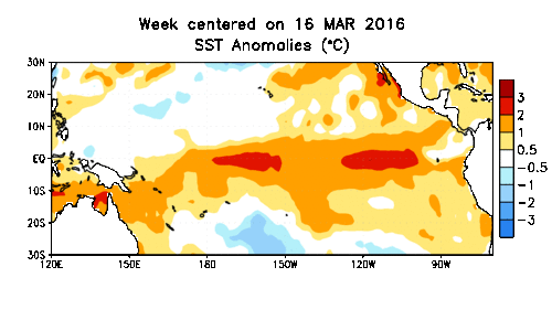
You can see by the animation the blue (cooler) water forming off the coast of South America near the equator. This signal may mean the start of a La Nina pattern, basically colder than average waters in the Eastern Pacific. This type of pattern tends to affect Colorado's weather just like El Nino does, but with different results.
I'll have a bigger post up this month on what this pattern may mean for Colorado's weather but most models place the possibility of a La Nina at nearly 75% by Fall... I like those odds!
Summary
June 2016 behaved in every way like a month we would expect to in the waning of a strong El Nino episode. We generally see warm and wet springs and transition into a warmer and average to slightly wetter than average summer and June had all of these attributes this year.
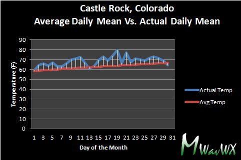
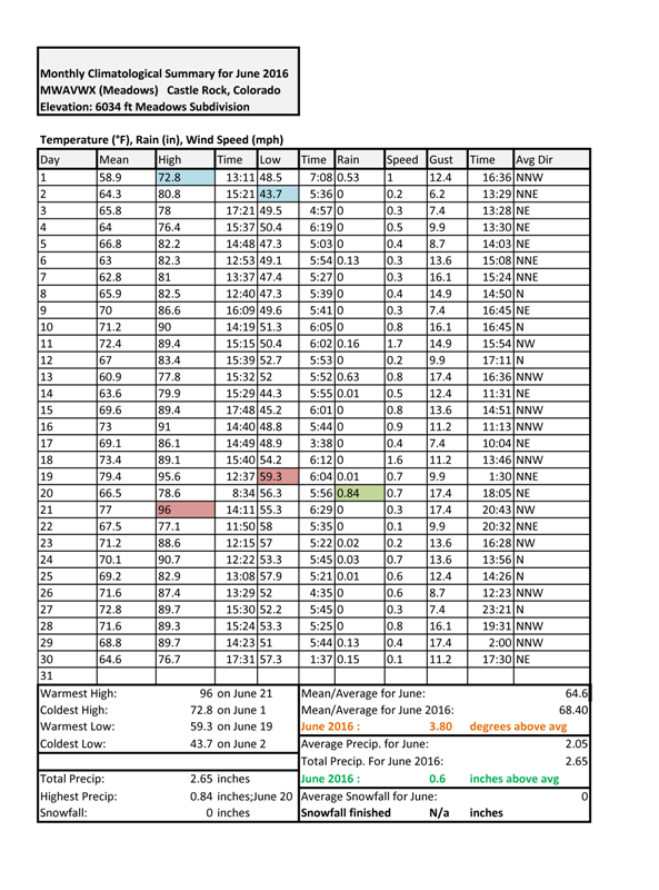
Mean temperature observed vs. average mean temp. Mean temps are calculated by taking the high and low temp divided by 2.
June was warmer than average, not too much of a surprise but for most areas East of the Continental Divide it was way above average for temperatures. You can see from the graphic above that the mean temperature for nearly every day this month was above average. This explains why the Castle Rock area was nearly 4 degrees above average, to say that June 2016 was a bit of a scorcher would be pretty accurate. With July coming up (our warmest month of the year) it will be interesting to see if this trend continues.
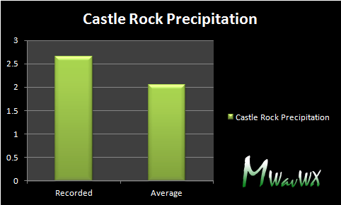
Recorded precipitation vs average precipitation observed in the month of June (taking a 30 year average.)
As many of you have guessed, June ended up above average on precipitation for the month. June itself is a fairly wet month for most of us in Colorado so to come in above average on that number takes some decent stormy activity. That being said, with high pressure in place provided some heat and fair weather over the area through most of the month, we didn't see a large number of days with rain. On the days it did rain however, we saw quite a bit.
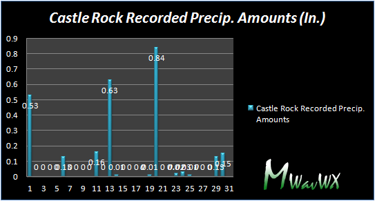
Observed precipitation for the Castle Rock area. Not a large number of days with rain, but days where rain was observed featured decently high amounts of collected precipitation.
July 2016 Outlook
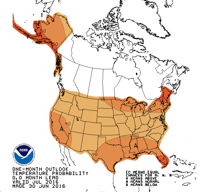
Climate Prediction Center July 2016 Temperature Outlook
With our El Nino pattern finally coming to an end we will move to a neutral pattern for a short time followed by a transition towards La Nina. We typically experience warmer than average temperatures during La Nina but the effect on temperatures is felt much more in the fall and winter months. As such, I would expect July's temperatures to be right around normal to slightly above normal. July is our warmest month so we'd have to have serious scorching heat to make it a well above average month, however June just showed us how easily that can happen.
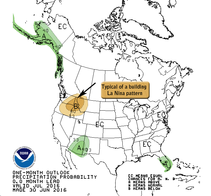
Climate Prediction Center July 2016 Precipitation Outlook
Precipitation will be a tough call just as June was. We generally see the monsoon kick up this time of year but many forecast models have not latched on to a sustained monsoon pattern this year. This is important because we receive a large portion of our moisture from the monsoon every year and if it ends up drier than normal we struggle to make it up the rest of the year. I'd expect July 2016 to be average to slightly below average based on what I've seen from forecast models, that being said my uncertainty is high on that forecast because it will all depend on whether we get that strong monsoon or not.
