Castle Rock Co Weather Climate Summary April - June 2017
A statistical look and discussion of weather recorded for Castle Rock Colorado. This information was collected and recorded via my weather station in the Meadows in the town of Castle Rock. It is in no way an “official” record, just simply what was recorded by my station. These stats include snowfall, temperatures, precipitation, wind intensity and direction for the month.
Summary
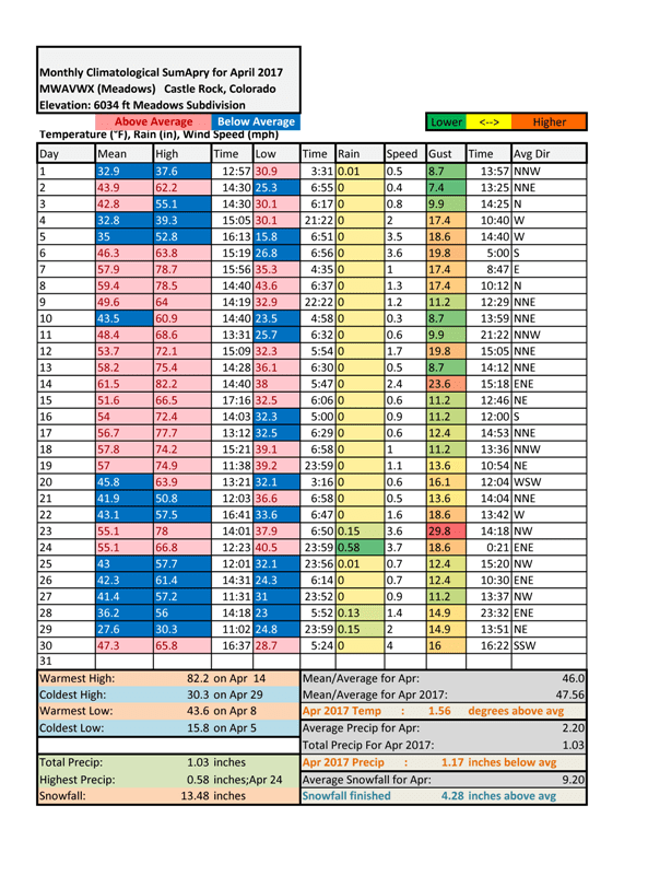
Weather statistics for April 2017 collected from our weather station in The Meadows in Castle Rock, Colorado
April 2017 finished as a warm and wet month in terms of snowfall, but dry month in terms of overall precipitation. How does something like that happen? While we saw decent snowfall in the first and last part of the month, it was quite dry in the middle part of the month with very little rain. So while the month finished above average in snowfall it was below average in actual liquid precipitation.
Temperatures
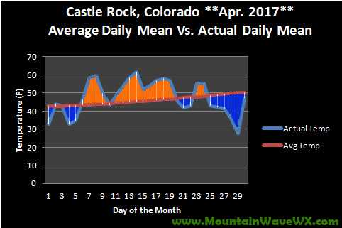
April 2017 mean (average) daily temperatures for Castle Rock Colorado.
April 2017 finished above average but only slightly. This is a big change from March where we saw huge swings of above average temperatures and the month finished nearly 6 degrees above average. There were more warmer than average days that colder than average but even during the above average days, none of them were outstandingly hot.
The monthly mean temperature for Castle Rock finished at 47.56 degrees which is 1.56 degrees above average.
Precipitation
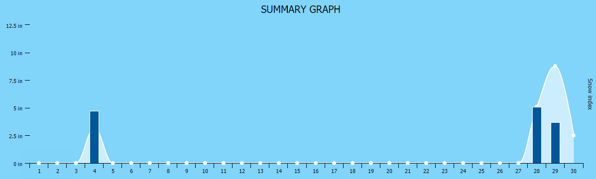
April Snowfall Tracker for Castle Rock, Colorado
April is our second snowiest month of the year, and overall it was a very dry month with very little storm systems bringing snow to our area. That being said, two storms did deliver enough snowfall to mark it as an above average snowfall month for Castle Rock. An early storm in the month brought a total of 4.71 inches to the Castle Rock area and a larger storm at the end of the month brought 2 days worth of snowfall. The first day totaled 5.1 inches and the second day 3.67 for a grand total of 8.77 inches. Most areas in and around Castle Rock recorded totals between 8-12 inches, which was pretty spot on with our forecast.
Total liquid precipitation for Castle Rock finished at 1.03 inches which is 1.17 inches below average.
Snowfall for Castle Rock finished at 13.48 inches which is 4.28 inches above average!
Summary
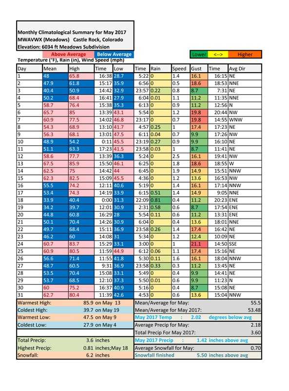
Weather statistics for May 2017 collected from our weather station in The Meadows in Castle Rock, Colorado. Notice all the blue, the month finished below average for temperatures!
May 2017 lived up to what we expect in a Colorado spring, it was a rollercoaster ride that featured everything from a late season snowstorm to damaging baseball sized hail hitting the Northwestern parts of Denver. We generally see an uptick in severe weather during the month of May but despite a few big, newsworthy storms it was a relatively quiet month. The big news is that the snow storm coupled with an overly wet pattern has put Colorado drought free statewide! This is great news, we hope the trend continues into June all indications are that for at least the first half of June, we could continue our wetter pattern.
Temperatures
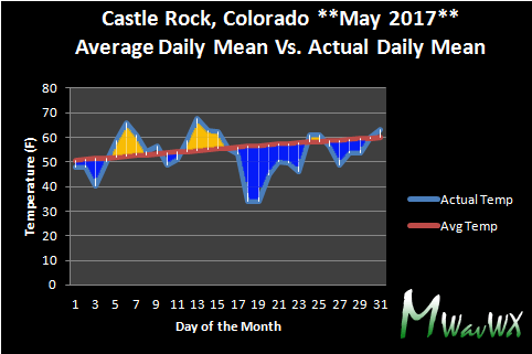
May 2017 mean (average) daily temperatures for Castle Rock Colorado.
May 2017 was the first month we've seen in quite awhile that actually finished with lower than average temperatures for the month! The cooler temperatures were very welcome after a stretch of several abnormally warm months throughout the fall, winter and spring season.
The monthly mean temperature for Castle Rock finished at 53.48 degrees which is 2.02 degrees below average.
Precipitation
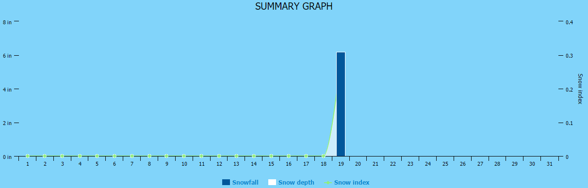
May Snowfall Tracker for Castle Rock, Colorado
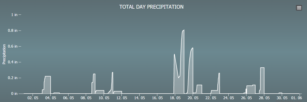
Graph of overall precipitation recorded for Castle Rock, Colorado
We had to track both snowfall and rainfall this month as we saw a large, late season snowstorm drop anywhere between 4-12 inches in and around Castle Rock (depending on where you lived.) We officially recorded 6.2 inches at our station in the Meadows. While snow is no stranger to the month of May along Colorado's front range, this particular storm was quite cold and wet for so late in the season. Additionally, the weather pattern has brought several wet, soaking storm systems to the region meaning that May 2017 finished well above average in terms of precipitation.
Total liquid precipitation for Castle Rock finished at 3.60 inches which is 1.42 inches above average.
Snowfall for Castle Rock finished at 6.2 inches which is 5.5 inches above average!
Current Drought Conditions
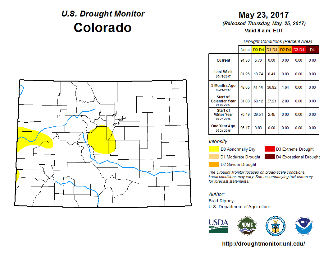
Current drought conditions across Colorado as of the end of May 2017
The latest drought monitor update for the state of Colorado shows no drought conditions at all in the state! This is the first time this has happened since 2001 but it's interesting to note the drought monitor was only started in 2000.
Keep in mind, even with the wet conditions we have now that we can still see drought conditions re-develop into the summer and late fall. Currently we don't see an extended period of heat or dryness that will change this in the near future, but we'll keep an eye on it!
June 2017 Outlook
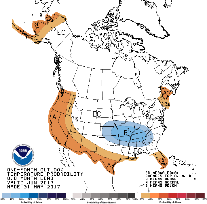
The latest CPC outlook for the month of June shows an equal chance of being above or below average for temperatures in June 2017.
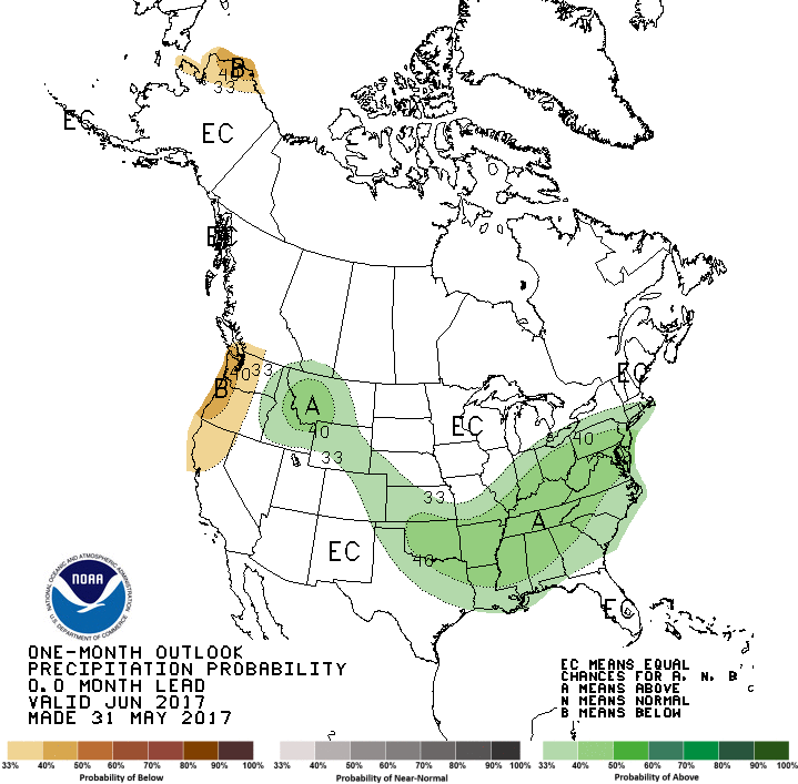
The CPC outlook for precipitation shows a higher than average probability that June 2017 will finish wetter than average.
Our Take
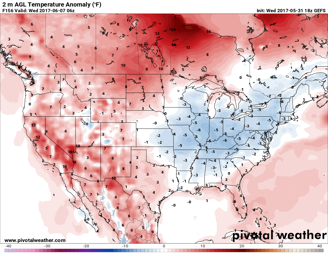
GEFS Long Range Ensemble Temperature Anomalies for 2m above ground level
As far as temperatures go, several longer range models show a solution similar to what the CPC has above. This means cooler temps East of Colorado in the middle section of the U.S. with average to slightly above average temps across Colorado. In fact, the only real glimpse of a heat wave or any above average temperatures comes towards the middle of the month with the warmest air remaining North of Colorado.
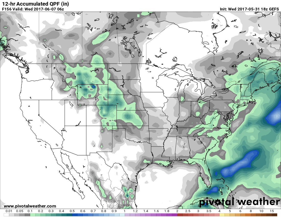
GEFS 12 hr QPF Models
The precipitation situation is a bit more interesting. Quite a few of the longer range models show a strong ridge setting up West of Colorado, this would mean that we would see warm temperatures but wet conditions. Mainly, the storm track won't be pushed far enough East of Colorado and we should see enough moisture remain in the atmosphere for pop up showers and thunderstorms.
Our prediction: Castle Rock will finish near normal to slightly above average on temperature and above average on precipitation for June 2017.
