The storm originating in the arctic areas of Alaska and Canada for the past week is beginning to come into focus on a lot of our medium range models and the longer ranges are starting to hammer out the details as well. This storm has had an interesting evolution as models have been consistent on the very cold temperatures since last week, but have flipped anywhere from over a foot of snow to nothing at all over the past few days. As we get closer, we start to see some agreement with models as we get more data. Let's take a look at what we see with this storm with the latest data out tonight.
Temperatures -- It's Going to be Cold!
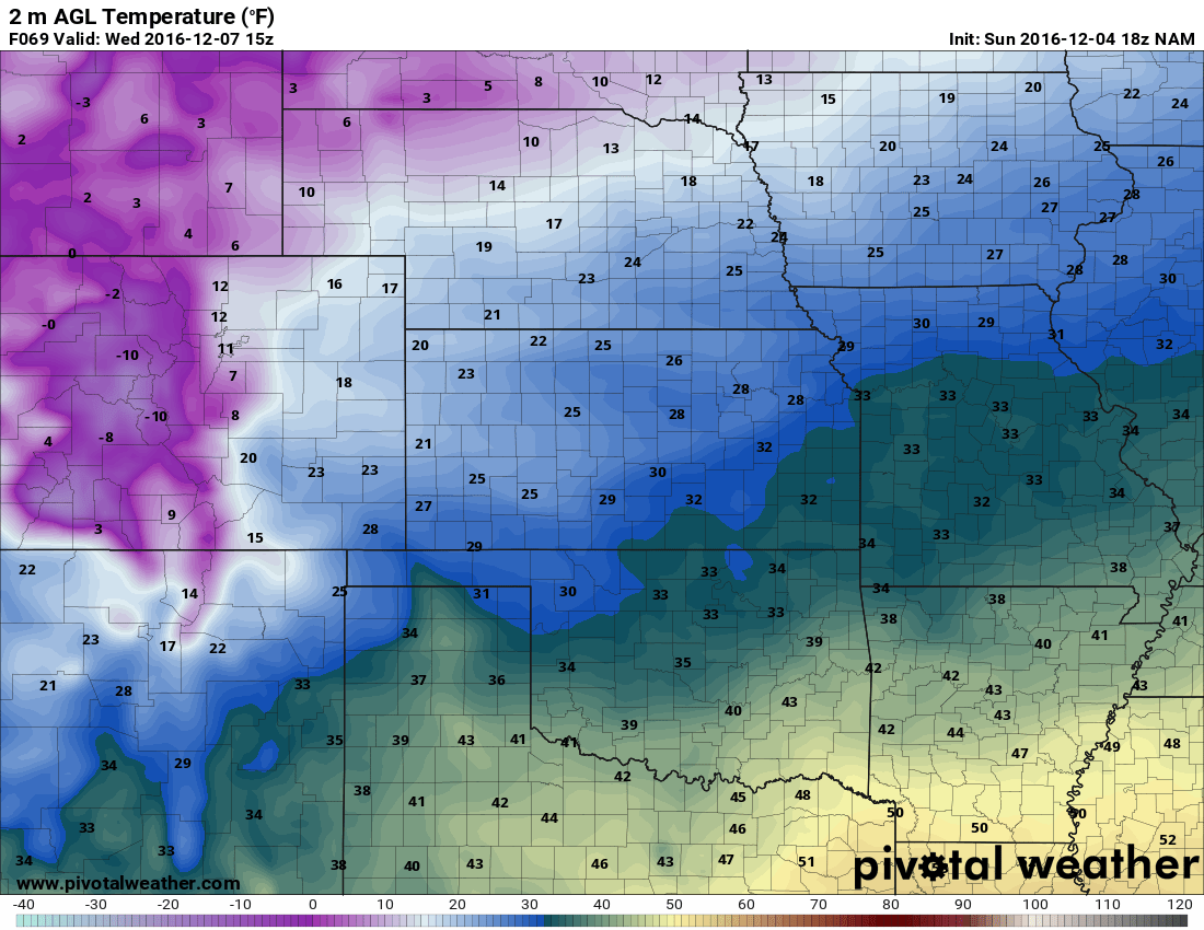
This has been pretty consistent with models since last week and the medium range models are beginning to confirm the blast of cold air expected to hit Colorado this week. The period of Tuesday through Friday looks pretty chilly but I believe the coldest days and nights will be Wednesday, Wednesday night, Thursday and Thursday night into Friday morning. Take a look at some the forecast temps from the NAM:

5AM Weds Temperatures
Wednesday 8am temperatures
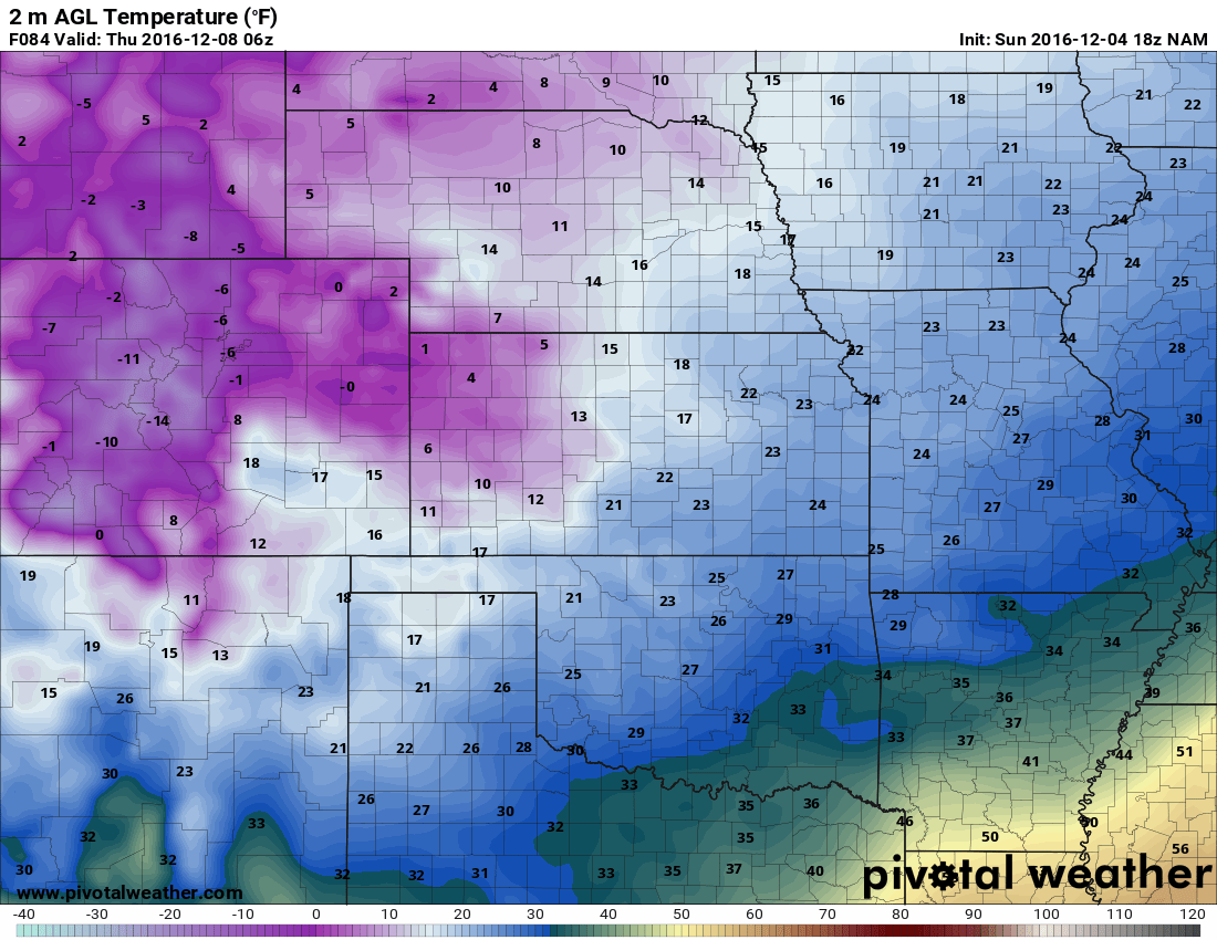
Weds 11PM temperatures
We get towards the end of what we can see with the Nam at this time with the 11pm Wednesday snapshot, but it is quite clear that the front range will be very chilly Wednesday night heading into Thursday morning. I have the weekly outlook posted below with the finer details on the temperatures.
Snow is Looking Very Likely!
For those waiting for another snow storm, this system will make you happy! While this is not a "city-crippling, blizzard" type storm, I do suspect we will see slightly more snow out of it than our last couple of storm systems. This is mainly because of the colder temperatures (snow will start sticking quicker) and the strong jet stream over the state could enhance upslope in specific areas (snow banding.)
**Banded snowfall can be tricky to predict as models struggle with placing where the bands show up. Additionally, areas that these snow bands anchor over could see periods of brief heavy to moderate snow and get more accumulation than areas literally only miles away.
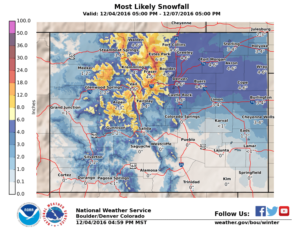
NWS most likely snowfall range for this storm
| For cities in Douglas, CO county -- Probability each area sees over a specific amount of snow |
| Location | At least | Likely | Potential for | >=0.1" | >=1" | >=2" | >=4" | >=6" | >=8" | >=12" | >=18" |
|---|---|---|---|---|---|---|---|---|---|---|---|
| Castle Rock, CO | <1 | 4 | 7 | 91% | 85% | 75% | 48% | 22% | 6% | 0% | 0% |
| Deckers, CO | 0 | 2 | 4 | 79% | 59% | 40% | 14% | 3% | 1% | 0% | 0% |
| Franktown, CO | <1 | 4 | 7 | 91% | 85% | 75% | 49% | 22% | 6% | 0% | 0% |
| Highlands Ranch, CO | <1 | 5 | 7 | 89% | 83% | 74% | 51% | 25% | 8% | 0% | 0% |
| Larkspur, CO | <1 | 3 | 7 | 91% | 84% | 74% | 48% | 24% | 9% | 1% | 0% |
| Monument Hill, CO | <1 | 3 | 8 | 91% | 85% | 75% | 51% | 30% | 14% | 2% | 0% |
| Parker, CO | <1 | 5 | 9 | 90% | 85% | 78% | 58% | 35% | 18% | 2% | 0% |
| Roxborough Park, CO | <1 | 4 | 7 | 88% | 82% | 72% | 49% | 25% | 9% | 0% | 0% |
The chart above is the probablisitc snowfall forecast from the NWS with data we have available tonight. This is presented to show what the most likely probabilities of being over a specific amount of snow for a specific area is.
Storm Timing, Snowfall and Impacts
The below information is my own specific forecast of what we expect to see in the Castle Rock area in terms of snowfall, timing and impacts. AS this is my own forecast, sometimes it is very similar to the National Weather Service's and sometimes it is different. Here's what I expect:
Timing
- The main impacts of this storm will be felt initially late in the day on Tuesday. Snow will begin sometime late in the day and should begin sticking soon if the temperatures trend colder.
- Expect snow to continue through the evening Tuesday and into Wednesday. All indications at this time are that the main bit of snowfall should be over by Wednesday afternoon.
Snowfall
- Preliminary amounts here but I expect snowfall to accumulate to 3-6 inches for most of the Castle Rock area by the time the storm moves out on Wednesday. My totals are slightly higher than the NWS as I expect colder temperatures and banded snowfall (see next bulletpoint) to boost our snowfall totals slightly in the area.
- One thing we have to watch closely is to see if a snowfall band (aided by upslope and the jet stream) sets up over Castle Rock or surrounding areas. A feature like that will mean an increased amount of snowfall accumulation over a very small area. This could even be a few inches difference from Eastern sections of Castle to Western, or Northern and Southeron. We will have to watch the radar closely for this as the storm moves in.
Impacts
- The initial impact from snowfall will be Tuesday night into Wednesday. I suspect if the models verify as they are now, the Tuesday evening and Wednesday morning commutes could be tricky. Plan accordingly!
- The secondary impact will be the extremely cold temperatures Wednesday and Thursday. The lows look to be below zero but I suspect the models may be underestimating the cold air, especially for the Castle Rock area. (I believe a combination of slightly more snow and higher altitude will aid in trending temperatures a bit lower.)
For the finer details on temperatures here's the 5 day outlook:
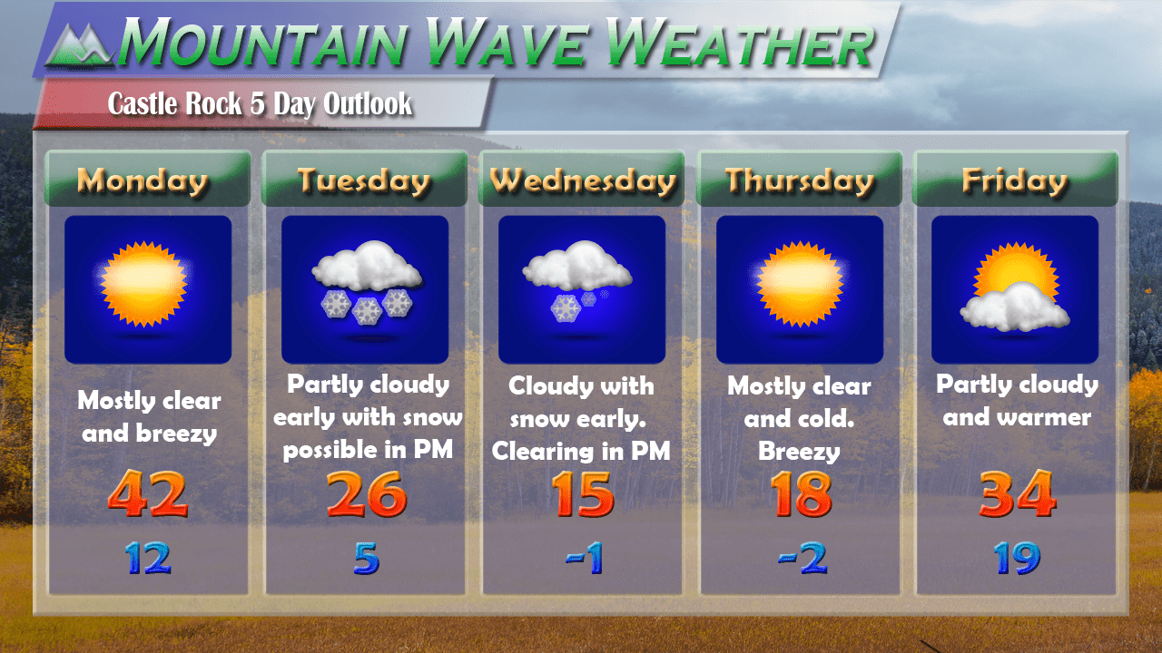
Keep in mind, I think temperatures may trend slightly colder on Wednesday and Thursday (especially the nighttime temperatures) We will see how this evolves over the next day or two in the models.
Summary
As I said earlier, this storm will not produce enough snow to shut down the city and doesn't warrant an emergency run to the stores. The biggest snow impact will be late Tuesday and Wednesday morning so if you have plans during those times keep a close on our weather updates (or whatever your favorite local weather source is.)
As we are still a couple of days out, I suspect this forecast may change slightly depending on the data we get in with the models on Monday. I think the overall storm will perform very close to what we have above but with weather there can always be a late curve-ball.
Stay tuned here for weather updates throughout the week as I'll be sure to pass along any updates or changes along with any late curve-balls (just in case we see something majorly change late in the game.) I'll most likely have an update Tuesday afternoon and night for this storm.

