A small disturbance will bring an end to our warm and dry weather, at least temporarily late Monday into Tuesday.This is an interesting storm as it is on a track that does not usually equate to lots of accumulation but as it crosses the rockies into Southeastern Colorado it is expected to intensify very rapidly. This means that the short period of time it sits in that position could mean at least somewhat decent snowfall accumulation for certain areas along the front range.
Storm Track and Position
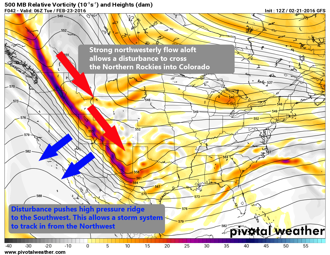 The ridge responsible for our warm weather the last couple of weeks has begun to slide back to the Southwest just a bit. This will make enough room in the atmosphere for a storm system to move into the state late Monday.
Storms like this generally don't bring us heavy snow accumulations as they are often quick to move through and out of the state before getting a chance to stall and dump snow over the front range.
What is interesting about this storm is how quickly it will intensify after it slides down over the Rockies and where this begins to occur is a quite favorable area for snowfall along the front range.
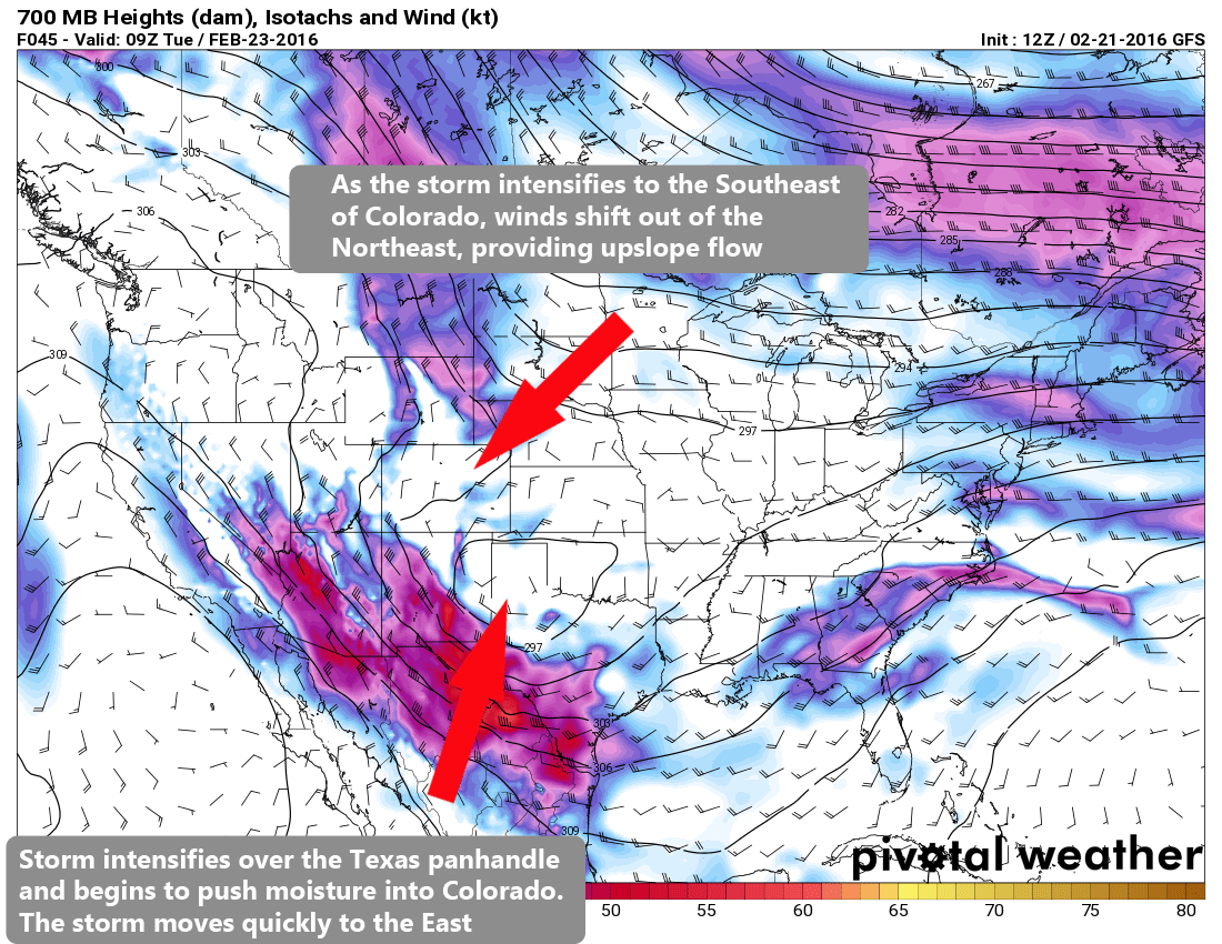
You can see in this model run of our low level winds, the storm looks to intensify as it moves into the Southeastern corner and off to the South into the Texas Panhandle. This is generally a very good area for big snow storms along the front range of Colorado, the problem is this particular storm system will move very quickly, meaning it won't sit over Colorado long enough to really dump on us.
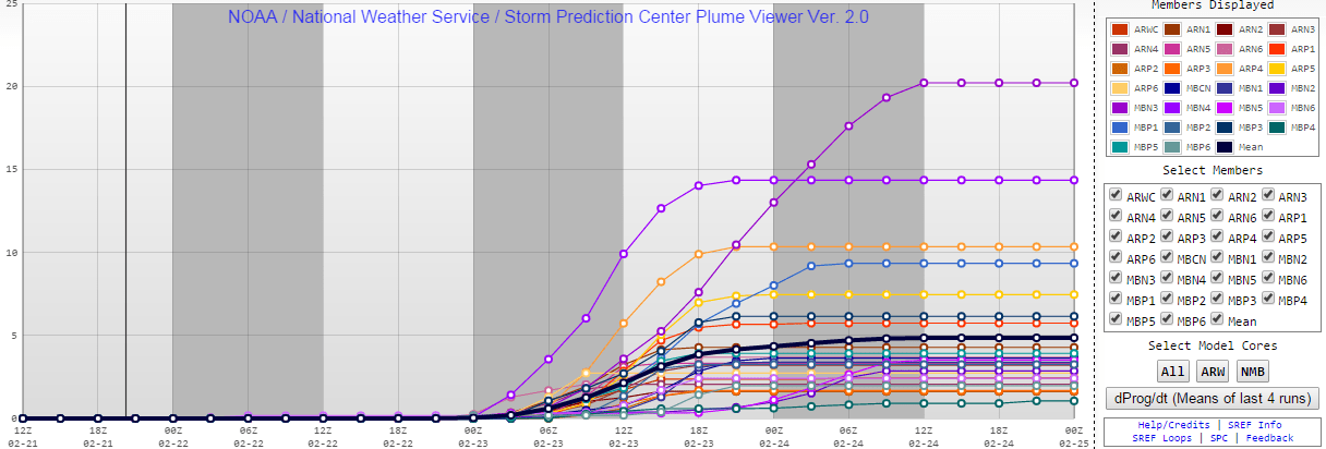
Every model has this system moving East very quickly so there is pretty high confidence in that area. Should the storm slow down at all it could mean slightly higher snow totals for some areas, but this looks unlikely at this point.
Model Predictions as of Sunday Afternoon
You can click on any of these images to see them full size, but here's a quick look at what the models are predicting through Tuesday afternoon:
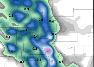
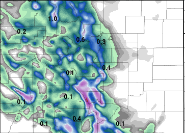
Nam QPF (how much liquid precipitation to expect)
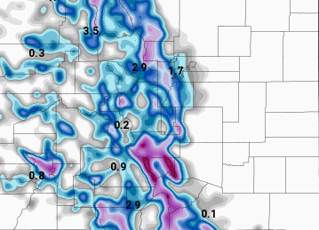
NAM total predicted snowfall using 10:1 ratio
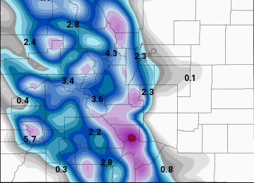
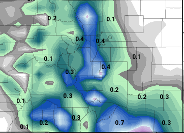
Nam4K QPF (how much liquid precipitation to expect) The Nam4K is a higher resolution model
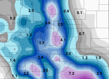
Nam4K snowfall prediction using 10:1 ratio
GFS QPF (how much liquid precipitation to expect)
GFS predicted snowfall using 10:1 ratio
NCEP Snowfall total. This product averages several different model runs together.
The general consensus with the major models is that the front range areas South and West of Denver will be the most favored. Temperatures are going to play a huge part of how much snow accumulates as well. With the warmer weather as of late, the ground is a bit warmer so it will take a bit more time to accumulate snow.
Current Forecast predictions:
- Denver: 1-3 inches of accumulation by Tuesday
- Castle Rock 3-6 inches possible, right now it looks like the lower end of that is most likely
- Western Suburbs: 4-8 inches, mainly in the foothills areas West of Denver and Southwestern Douglas County
What to Expect with this Storm
The main impacts of this storm will be felt late Monday night into Tuesday morning:
- Strong northwesterly winds
- Accumulating snow overnight Monday into Tuesday morning
- Expect a slower commute Tuesday morning into work
- Roads will most likely be slushy and possibly snow packed Tuesday morning, especially for areas South and West of Denver.
As of right now, no weather watches or warnings have been issued, but we will keep an eye on this storm and update our site as needed.
As always, you can check for Colorado watches and warnings here: Mountain Wave Weather Watches and Warnings
Stay tuned!


