You'll hear a lot of meteorologists and news station calling this storm a "complex" storm and in all aspects of that word it is! One of the meteorologists I regularly follow and speak with in Colorado Springs said it best today:

This is a very difficult storm to predict, one of the most difficult in a long time I've seen and I'll explain a bit why later in this post. For now, let's get to the important stuff!
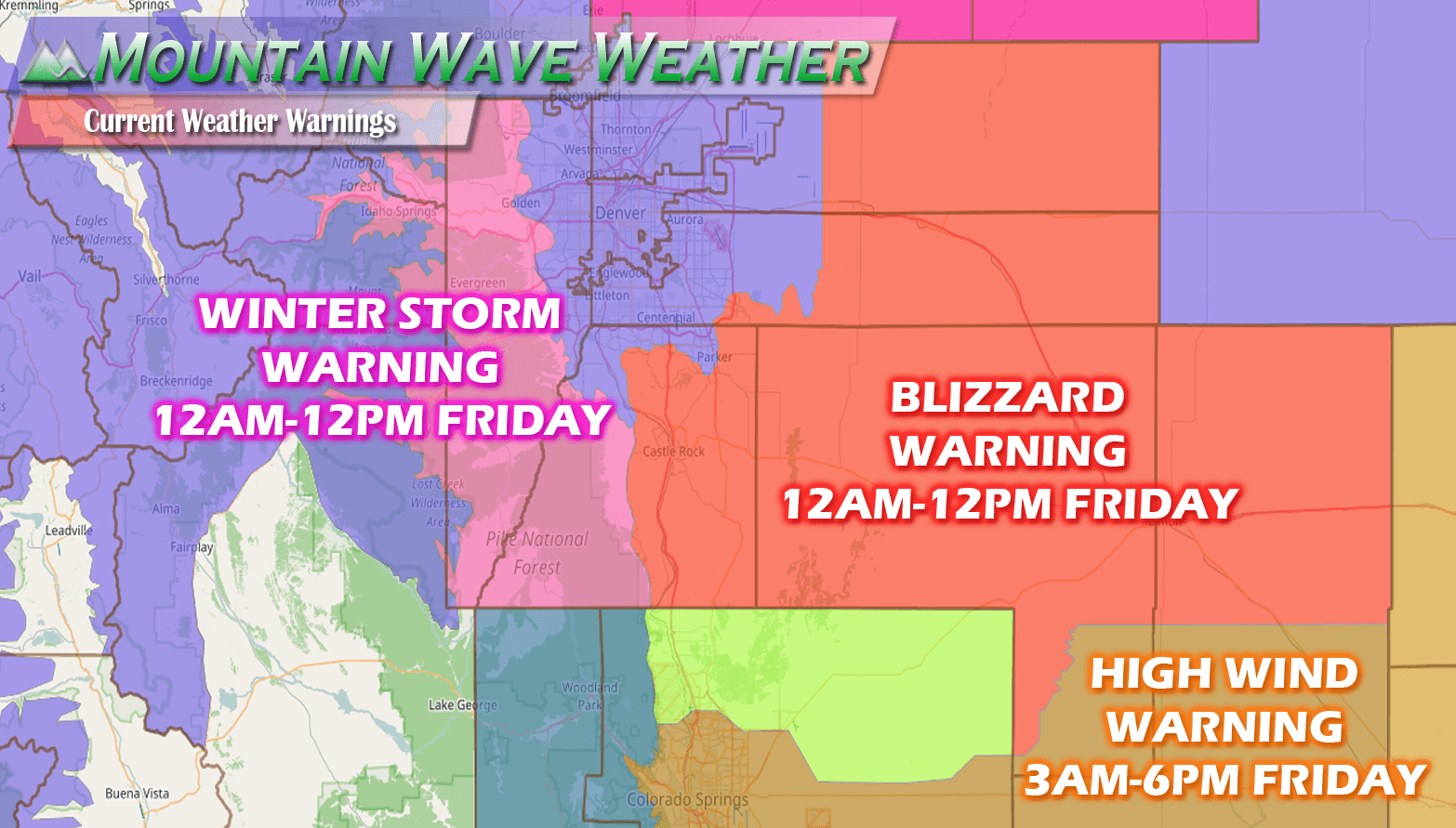
Colorado Winter Weather Watch/Warning/Advisory Information as of This Evening
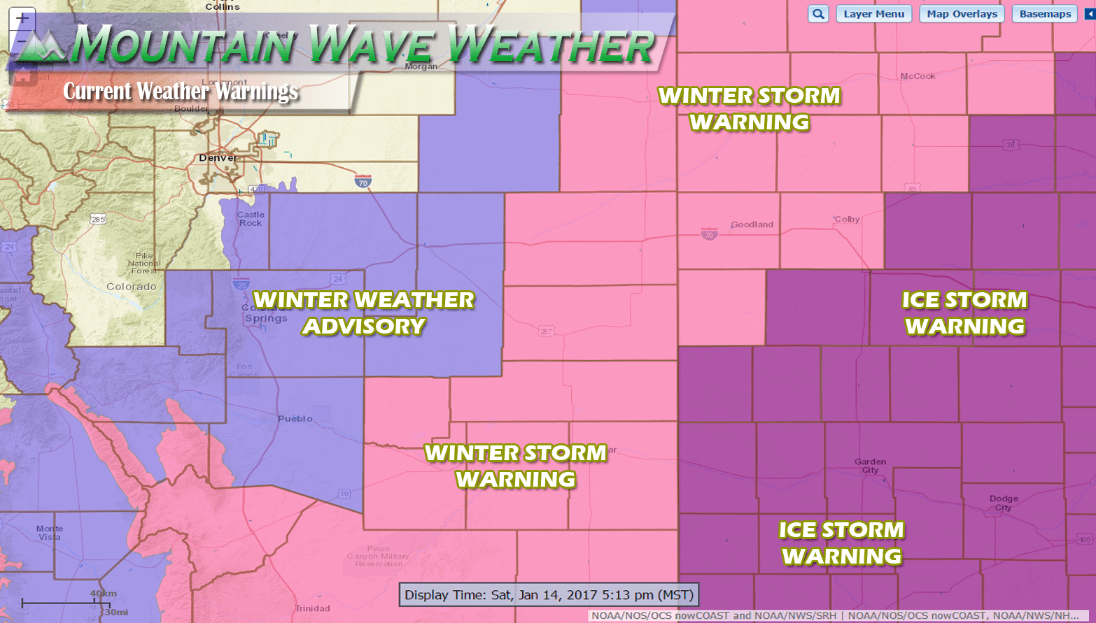
- Winter Weather Advisory
- Duration: Sunday 6AM - Monday 11AM
- Locations: CASTLE ROCK, ELBERT, FONDIS, KIOWA, LARKSPUR, JULESBURG, OVID, SEDGWICK, AMHERST, HAXTUN, AND HOLYOKE
- Issued for: Snow and Ice Accumulation, hazardous driving conditions possible.
- Severity: Minor
- Winter Storm Warning
- Duration: NOW - Monday 11AM
- Locations: Southern,Southeastern and Extreme Eastern Colorado
- Issued for: TRAVEL WILL BE HAZARDOUS DUE TO HEAVY SNOW...POOR VISIBILITIES AND ICY...SNOW COVERED ROADS.
- Severity: Significant
- Ice Storm Warning
- For portions of Kansas and Oklahoma, only including this because we are in the midst of a big travel weekend!
AN ICE STORM WARNING MEANS SEVERE WINTER WEATHER CONDITIONS ARE
EXPECTED OR OCCURRING. SIGNIFICANT AMOUNTS OF ICE ACCUMULATIONS
WILL MAKE TRAVEL DANGEROUS OR IMPOSSIBLE. TRAVEL IS STRONGLY
DISCOURAGED. COMMERCE WILL LIKELY BE SEVERELY IMPACTED. IF YOU
MUST TRAVEL...KEEP AN EXTRA FLASHLIGHT...FOOD...AND WATER IN YOUR
VEHICLE IN CASE OF AN EMERGENCY. ICE ACCUMULATIONS AND WINDS WILL
LIKELY LEAD TO SNAPPED POWER LINES AND FALLING TREE BRANCHES THAT
ADD TO THE DANGER.
More Information
See all Castle Rock specific Watches/Warnings/Advisories on our Weather Warnings Page
Visit Weather.gov for the latest National Weather Watches and Warnings
Latest Update for the Castle Rock/ Palmer Divide Area
The latest Winter Weather Advisory does include the Castle Rock area, but does not include all of Douglas County. Areas North of about Lincoln Avenue and West of there are not included in this advisory, here's a closer look:
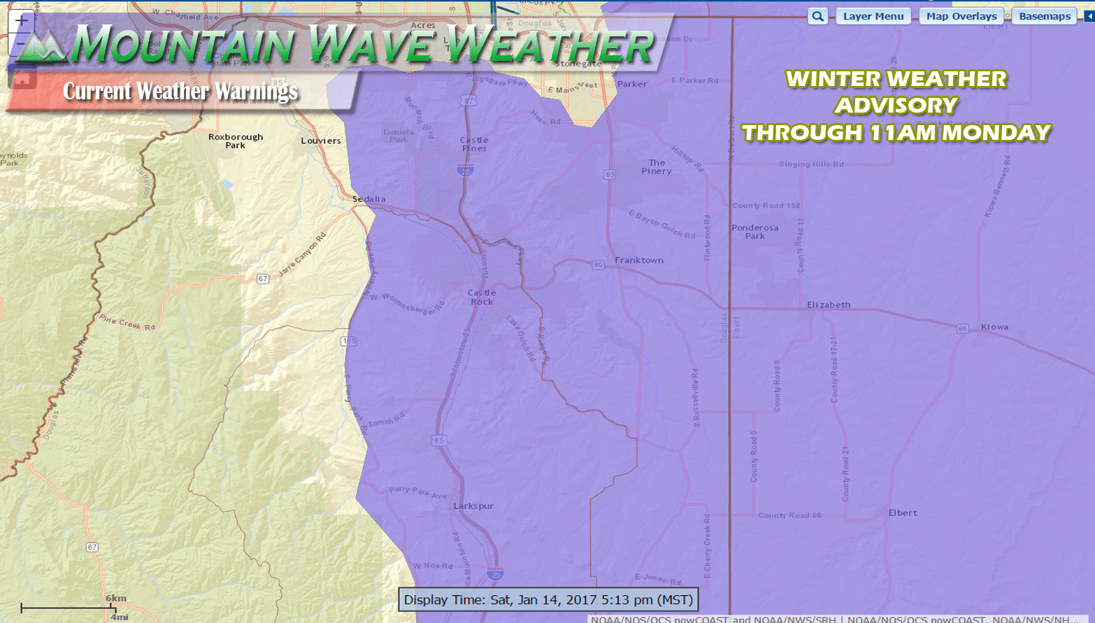
The advisory for the Castle Rock area is mainly out because we expect the possibility of freezing rain overnight and into the early morning hours on Sunday. Additionally, snow will begin later in the day and last through late Monday morning. The combination of freezing rain (freezes instantly when it hits a surface) and the snow later on could make for difficult travel conditions at times during Sunday.
Since our models and forecasting tools don't seem to be able to make up their mind on this storm (they usually are all in agreement this close to a storm) we are going to have to do some probablistic forecasting with this storm. This means we will take a look at a couple scenarios that could play out and describe their likelihood of verifying.
Snowfall Accumulation
| For cities in Douglas, CO county |
| Location | At least | Likely | Potential for | 0" | 0.1-1" | 1-2" | 2-4" | 4-6" | 6-8" | 8-12" | 12-18" | >18" |
|---|---|---|---|---|---|---|---|---|---|---|---|---|
| Castle Rock, CO | <1 | 3 | 9 | 8% | 6% | 8% | 21% | 21% | 15% | 17% | 4% | 0% |
| Deckers, CO | <1 | 2 | 6 | 7% | 9% | 15% | 33% | 23% | 10% | 3% | 0% | 0% |
| Franktown, CO | <1 | 3 | 9 | 8% | 5% | 9% | 22% | 20% | 15% | 17% | 4% | 0% |
| Highlands Ranch, CO | 0 | 2 | 7 | 12% | 9% | 12% | 23% | 19% | 12% | 11% | 2% | 0% |
| Larkspur, CO | 1 | 3 | 9 | 4% | 5% | 9% | 23% | 22% | 17% | 16% | 4% | 0% |
| Monument Hill, CO | 2 | 4 | 10 | 4% | 4% | 6% | 19% | 21% | 18% | 21% | 7% | 0% |
| Parker, CO | <1 | 2 | 10 | 10% | 7% | 8% | 19% | 17% | 14% | 17% | 7% | 1% |
| Roxborough Park, CO | 0 | 2 | 10 | 11% | 6% | 9% | 17% | 16% | 13% | 17% | 10% | 1% |
Since our models are not helping us out too much the probabilities of snowfall are scattered. For the latest data in this evening, I'd put the most likely storm accumulation at the 2-6 inch range for Castle Rock. Notice however, the probabilities for the 4-8 inch range are quite elevated but a little less likely. Interestingly, the 8-12 inch range is less likely than our forecast range but is slightly higher than the 4-8 inch range, interesting... This forecast mirrors what we see in the models and it shows the uncertainty based on the wide spread we have.
The models are usually in pretty good agreement with storms like this by now but they are definitely not helping us with this storm, take a look!
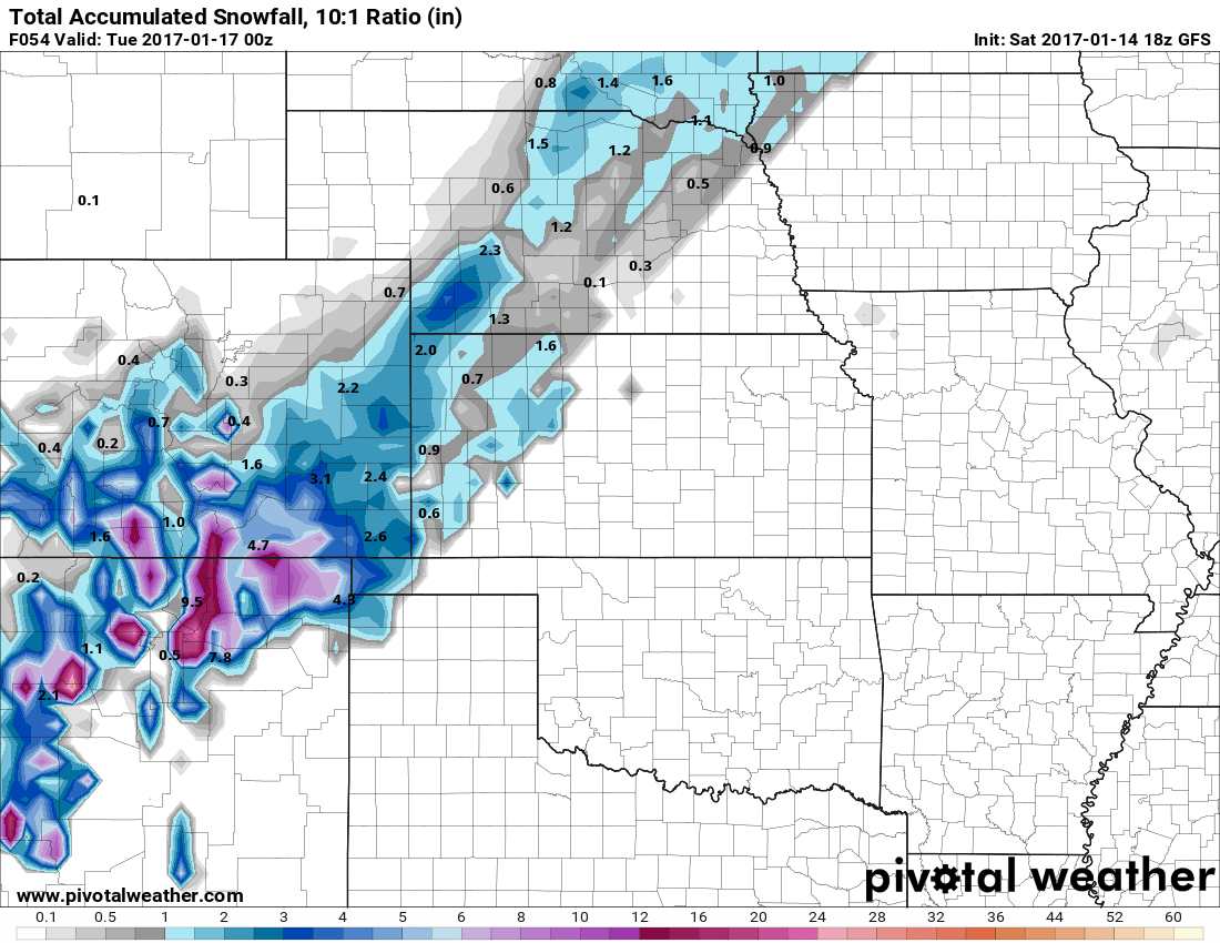
The GFS shows a total of less than an inch accumulation by 5PM Monday.

The NAM4k shows a total of 4.5 inches by 5PM Monday. At the moment somewhere around this range seems most likely.
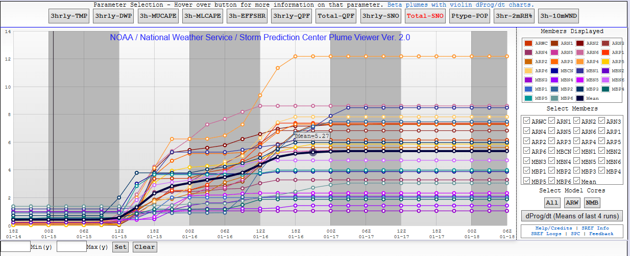
SREF Plume Ensemble shows a mean of a little over 5 inches total by Monday 5PM.
For what it's worth, the EURO Ensembles have a 6-12 or even 8-16 inch range possible
If we take all 4 models and average them out (keep in mind the SREF ensemble is many models in and of itself) we get an average of 5 inches. That seems to be relatively likely but the Euro is a huge outlier, if it is correct we could see a decent snow out of this, but at this time the Euro solution looks unlikely to verify.
Here's the latest probability ranges from the National Weather Service.
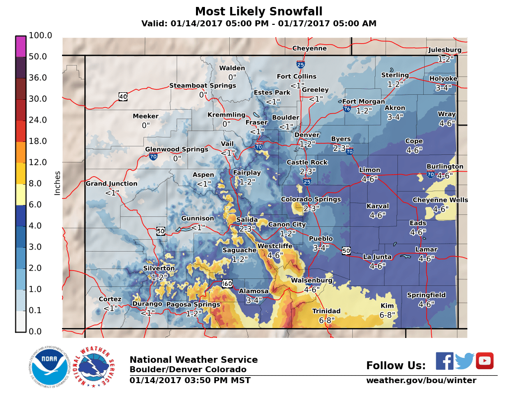
This is the most likely range of snowfall across Colorado at this time. Notice the Castle Rock range fits well within our initial forecast (see below)
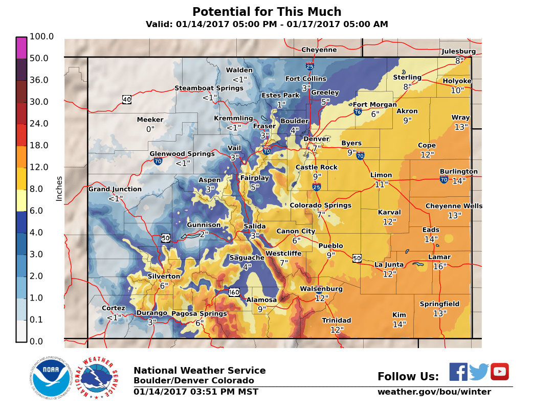
NWS prediction of what amounts could fall if the storm verifies more towards the Euro solution. The probability of seeing these amounts is lower but not a ton lower than hitting our most likely forecast range.
Storm Timing, Snowfall and Impacts (Our Official Preliminary Forecast)
This storm has a high probability of going either way, there is so much uncertainty with the models that a lot of us have had to call this a bit using instinct. While I love the idea of the Euro solution (6-16 inches of snow) it just seems too unlikely to verify with all the other factors going on. There is still the real possibility this storm completely misses the Castle Rock area and the probability of that is equaly high to the probability of us getting 6-12 inches.
Timing
- An initial band of precipitation may move through early Sunday, the atmosphere could be conductive to freezing rain so that's something to watch for.
- Expect the main snow event to kick in later in the day Sunday and into Monday.
Snowfall
- Uncertainty is high even now with this storm.
- 2-6 inches is the range most likely in Castle Rock at this time. Usually I'm locked in on a total right now but the hard truth is this amount could be drastically different when we see more data later tonight and Sunday morning. Best to call this a "floating" prediction at this time.
Impacts
- Initial impacts will be slick roads possible Sunday morning as freezing rain or light snow could be possible.
- Keep a close eye out for tough travel conditions Sunday morning and again later in the day Sunday, overnight and into Monday morning. The Monday morning drive might be affected (for those of us working.)
This storm is a highly evolving situation. Expect our snow total forecast to shift late Saturday, early Sunday and even possibly later in the day Sunday. It's the best we can do with all the uncertainty in the data we are getting in at this time. Until the models start to align with each other one way or another, we are going to have a tough time with this one.
I'll be sure to update as soon as I get new information in, stay tuned!
