Colorado's front range started the month of February with a large snowstorm that deposited a foot of snow or more for many areas. I've heard a lot of discussion about when we can expect our next snowstorm as many are eager to plan their next snow day. February tends to be one of our drier winter months, we often see warm days and little snow during February so it was somewhat unusual to see such high snow amounts in one storm for the month. This is why it's important to keep in mind throughout this dicussion that just one storm in the entire month can bump February into an over average precipitation situation. The average snowfall for February in the Castle Rock area for example, is 7.2 inches.
I've been analyzing outlooks, models and statistics and now have a decent picture of what we can expect in Colorado for the rest of this month.
Wetter Than Average but Any More Snowstorms?
The Climate Prediction Center runs a whole host of products that calculate the probability of temperature and precipitation anomalies. They are a great tool to get a big picture of the weather for the U.S. over periods of weeks or months. Their February prediction was released on January 31 and highlights the following:
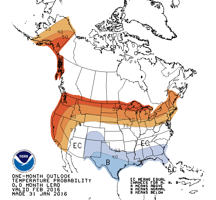
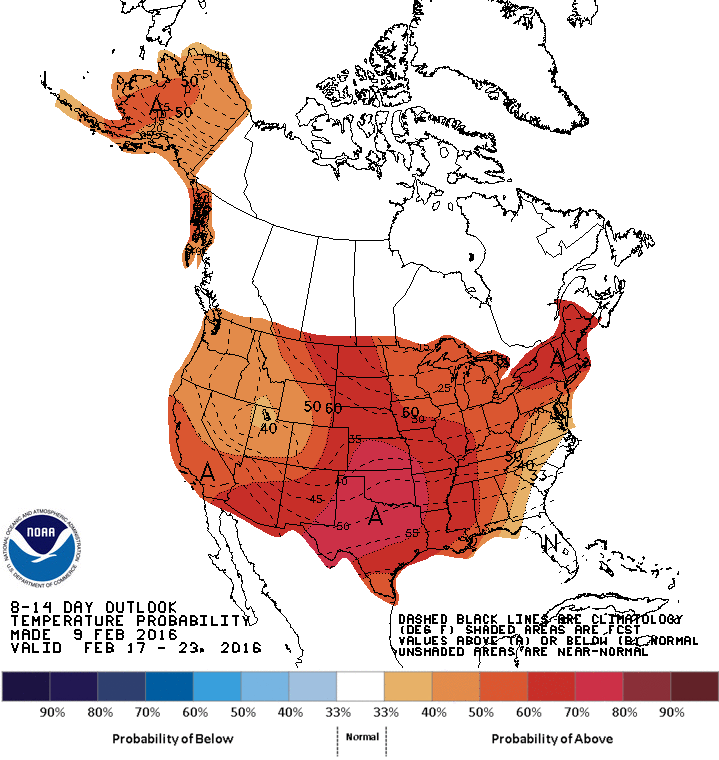
CPC February 2016 Temperature Outlook
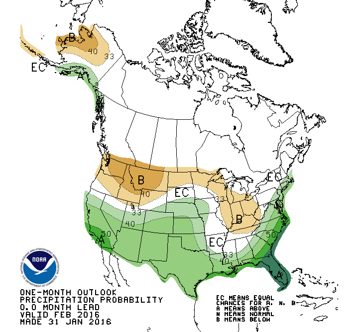
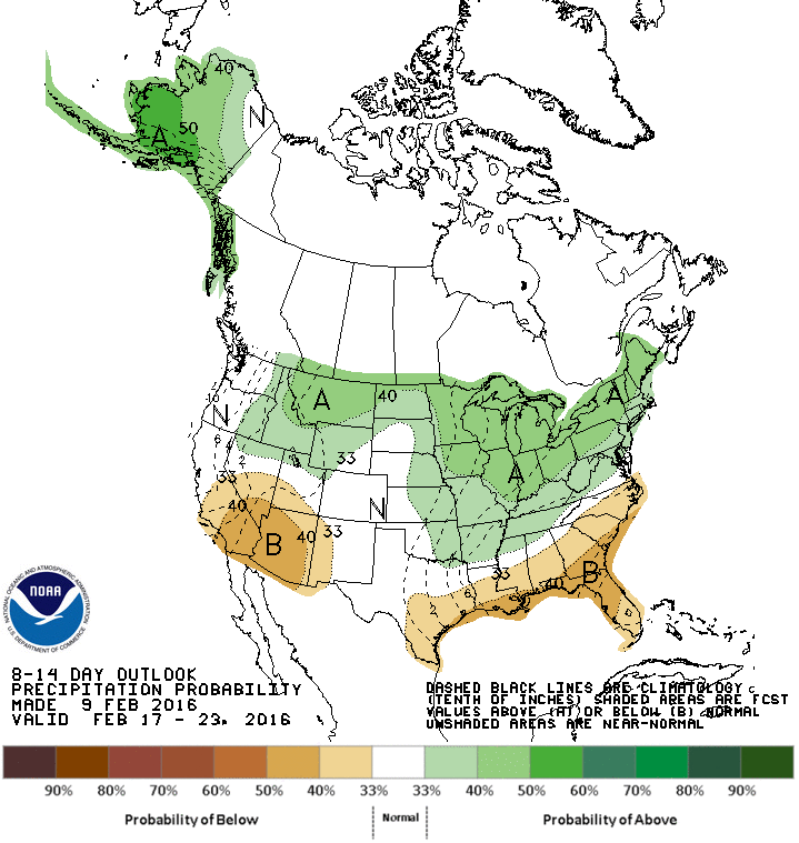
CPC February 2016 Precipitation Outlook
A quick look at the CPC February temperature outlook to the left shows the probability of temperatures being above or below average. The redder colors signify a higher chance of above average temperatures to finish the month whereas the blues snow a higher chance of below average temperatures.
The February outlook shows a slightly higher chance that most of Central and Southern Colorado will have below average temperatures. The Northern and Northwestern and to some degree the Northeastern corners show equal chances of above or below average temperatures. This is weather speak for, "it could go either way."
The daily mean temperature for the Castle Rock area is 33.0 degrees and as of this post we are sitting at 21.9. Granted it is still quite early in the month and we are expecting some very warm days in the weeks ahead, this could change. As of right now the CPC outlook is right on target with below average temperatures.
When we look at the precipitation outlooks it shows a pretty decent chance of above average precipitation for the month. This is pretty much verified at this point since our early month snowstorm dropped more than a foot across the front range of Colorado. In addition, the mountains have received large amounts of snow continuously throughout late January and into February.
Since we are already at above average precipitation for the month,we can consider this outlook spot on. Now that we've looked at the month as a whole and found that things are pretty much going to plan, now we can start digging down into some deeper details about the next few weeks.
Next 6-10 Days
The CPC outlook for the next week or so essentially paints a bulls-eye for warm temperatures over the Western U.S.
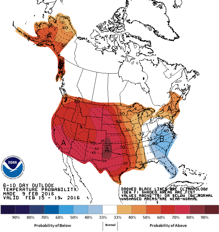
As with many meteorology cases, it is always worth verifying this information. This is essentially a forecast so should this verify, we should see signals in the atmosphere to support it. What we would expect to see in the atmosphere with a period of drier and warmer weather is some sort of ridge building into the Western part of the country.
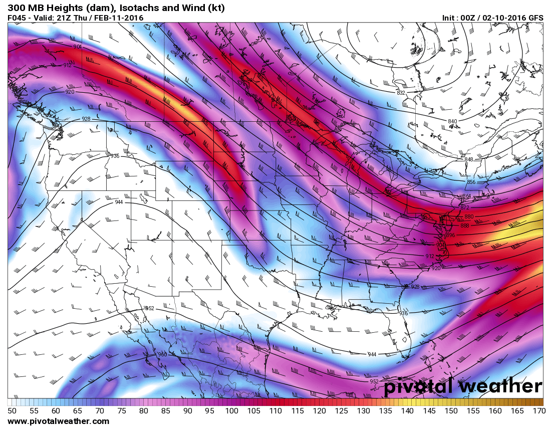
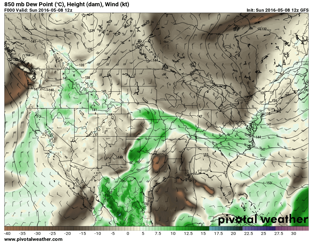
A look at the GFS model shows a pretty convincing signal. The upper level jet stream (winds at about 30,000 feet above sea level) show a very large and pronounced ridge across the Western U.S. In fact, this feature stays with us for quite a while and that's why you will see a very similar outlook from the CPC for the next period which is 8-14 days out. A high pressure ridge over the state allows warm air to migrate North but also keeps storms away from Colorado.
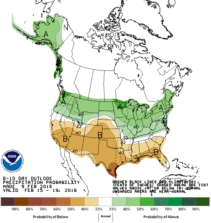
Next 8-14 Days
Not much more to explain here, we see a very similar outlook.
A much higher probability of above average temperatures with an equal chance of above or below average precipitation. All indications are at this point that the next 14 days will feature below average precipitation as that ridge is projected to continue over the Western U.S.
February Outlook Summary
With the current signals in the atmosphere here is what you should expect the rest of the month of February:
- Above average precipitation
- Mainly from our snowstorm at the beginning of the month, we have already recorded above average snowfall
- I suspect the rest of February will be quite dry, things may see a change towards the end of the month but next 14 days look like a sure lock on dry weather
- Average to slightly above average temperatures
- The first week of the month started off quite cool, so as of this write-up, our mean temperature is well below average.
- Given the next 2 weeks of much above average temperatures, I can see the mean rising very quickly.
- I expect temperature to finish above average slightly or very close to average depending on how the last week of the month acts.
This should shine a light on the next 14 days and I think it will be pretty accurate. A look at temperatures for the next 2 weeks shows consistent daily highs in the 50's and 60's as far out as I can see. Our nighttime temperatures will be much warmer as well, projected to be in the upper 20's and even lower 30's in some cases.
I will be digging through more data in the coming days and should have a spring preview up this week that will highlight what to expect in February through April 2016. It should be a nice sneak preview of spring, stay tuned!

