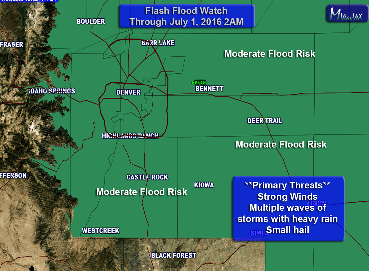
Current Flash Flood Watch Area
A strong storm system will begin to fire off storms along the front range this afternoon. Many of these storms are already in the process of of initiating along the Denver urban corridor. A series of fronts will bring cooler air and moisture with strong upslope conditions forming behind each front.
Because of these conditions and a lack of upper level support, storms that do form will move very slowly or in some cases not at all. Air convergence will also mean storms may form over the same places over and over again, these conditions lead to the possibility of flooding.
Most models show the highest amounts of rain North of Denver and in areas around the Palmer Divide. I think rain will be possible for most of us in and around Castle rock today but the day I'm more concerned about is Friday. Some models show upwards of 3-4 inches of rain from storms that form along the Palmer Divide. This is nothing to get terrible worried about yet but worth noting if you have plans late in the day Friday.
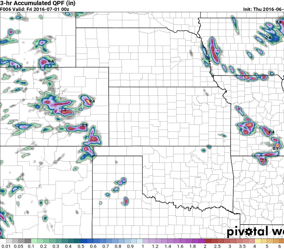
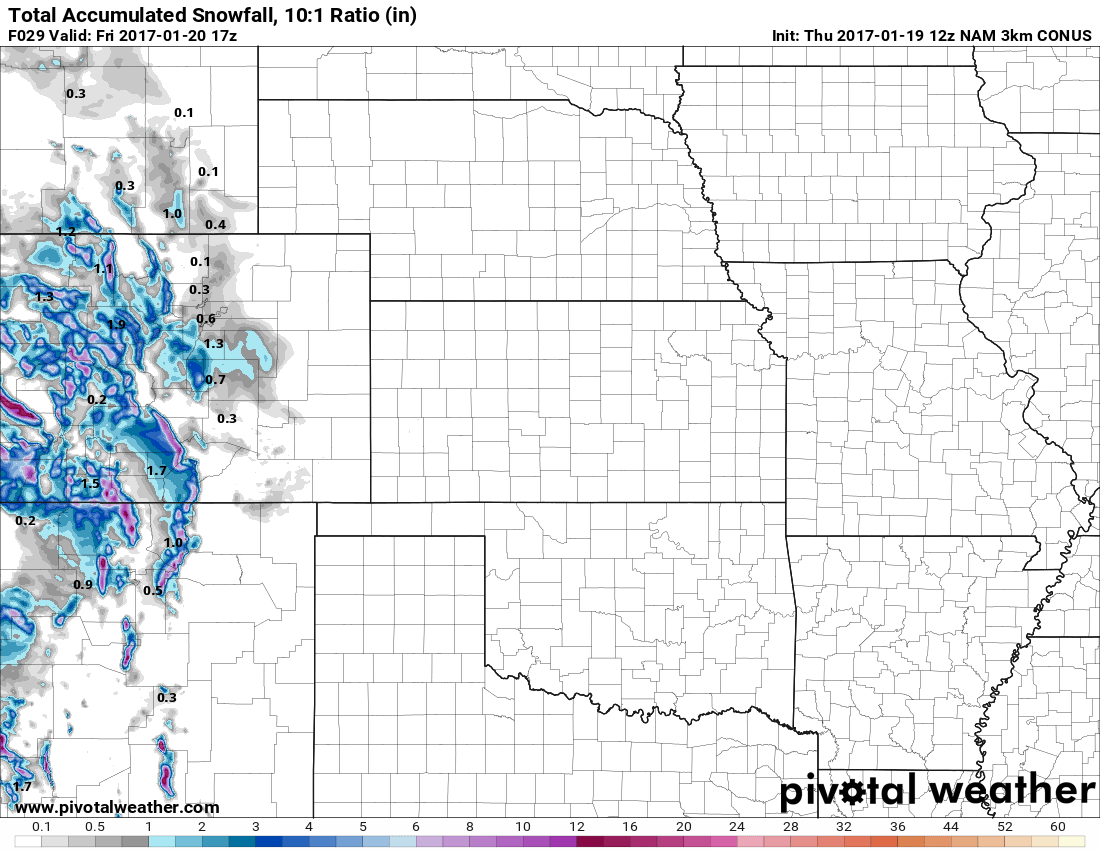
Nam4k QPF for Thursday
The graphic above shows predicted rainfall through Thursday night, notice the most likely areas are Northern parts of the state and along the Palmer Divide. Not all models agree with this solution though, some show higher rain and some lesser so there is still a bit of uncertainty on Thursdays situation.
Friday looks a lot more interesting, not going to show the models just yet because there is a ton of disagreement on areas and amounts, but a lot of agreement that someone will get hammered.
I'll have another update out on Friday morning with new model guidance and information, just be prepared for nasty weather in some areas if you are out and about on Friday afternoon, evening and overnight.
Stay tuned!
Flash Flood Watch Details
FLOOD WATCH
NATIONAL WEATHER SERVICE DENVER/BOULDER CO
213 PM MDT THU JUN 30 2016

COZ035-036-038>051-010415-
/O.NEW.KBOU.FF.A.0001.160630T2200Z-160701T0800Z/
/00000.0.ER.000000T0000Z.000000T0000Z.000000T0000Z.OO/
LARIMER AND BOULDER COUNTIES BETWEEN 6000 AND 9000 FEET-
JEFFERSON AND WEST DOUGLAS COUNTIES ABOVE 6000 FEET/GILPIN/CLEAR
CREEK/NORTHEAST PARK COUNTIES BELOW 9000 FEET-
LARIMER COUNTY BELOW 6000 FEET/NORTHWEST WELD COUNTY-
BOULDER AND JEFFERSON COUNTIES BELOW 6000 FEET/WEST BROOMFIELD
COUNTY-
NORTH DOUGLAS COUNTY BELOW 6000 FEET/DENVER/WEST ADAMS AND
ARAPAHOE COUNTIES/EAST BROOMFIELD COUNTY-
ELBERT/CENTRAL AND EAST DOUGLAS COUNTIES ABOVE 6000 FEET-
NORTHEAST WELD COUNTY-CENTRAL AND SOUTH WELD COUNTY-MORGAN COUNTY-
CENTRAL AND EAST ADAMS AND ARAPAHOE COUNTIES-
NORTH AND NORTHEAST ELBERT COUNTY BELOW 6000 FEET/NORTH LINCOLN
COUNTY-
SOUTHEAST ELBERT COUNTY BELOW 6000 FEET/SOUTH LINCOLN COUNTY-
LOGAN COUNTY-WASHINGTON COUNTY-SEDGWICK COUNTY-PHILLIPS COUNTY-
INCLUDING THE CITIES OF...ESTES PARK...GLENDEVEY...NEDERLAND...
RED FEATHER LAKES...BAILEY...CENTRAL CITY...EVERGREEN...
GEORGETOWN...IDAHO SPRINGS...WESTCREEK...FORT COLLINS...
HEREFORD...LOVELAND...NUNN...ARVADA...BOULDER...GOLDEN...
LAKEWOOD...LONGMONT...AURORA...BRIGHTON...CITY OF DENVER...
DENVER INTERNATIONAL AIRPORT...HIGHLANDS RANCH...LITTLETON...
PARKER...CASTLE ROCK...ELBERT...FONDIS...KIOWA...LARKSPUR...
BRIGGSDALE...GROVER...PAWNEE BUTTES...RAYMER...STONEHAM...EATON...
FORT LUPTON...GREELEY...ROGGEN...BRUSH...FORT MORGAN...GOODRICH...
WIGGINS...BENNETT...BYERS...DEER TRAIL...LEADER...AGATE...HUGO...
LIMON...MATHESON...FORDER...KARVAL...KUTCH...PUNKIN CENTER...
CROOK...MERINO...STERLING...PEETZ...AKRON...COPE...LAST CHANCE...
OTIS...JULESBURG...OVID...SEDGWICK...AMHERST...HAXTUN...HOLYOKE
213 PM MDT THU JUN 30 2016

...FLASH FLOOD WATCH IN EFFECT THROUGH LATE TONIGHT...

THE NATIONAL WEATHER SERVICE IN DENVER HAS ISSUED A

* FLASH FLOOD WATCH FOR THE NORTHEAST PLAINS AND FRONT RANGE
  FOOTHILLS IN COLORADO INCLUDING THE DENVER METRO AREA

* THROUGH LATE TONIGHT.

* NUMEROUS THUNDERSTORMS WILL DEVELOP BY THIS EVENING AND SHIFT
  SLOWLY EASTWARD OVERNIGHT. THE AIR IS VERY MOIST AND SOME OF THE
  STORMS COULD BE STATIONARY FOR A FEW HOURS RESULTING IN SEVERAL
  INCHES OF RAIN AND FLASH FLOODING. THE RISK OF STATIONARY STORMS
  AND FLASH FLOODING IS HIGHEST SOUTH OF A LINE FROM CASTLE ROCK
  TO AKRON...BUT THERE IS STILL A LOWER THREAT OF FLOODING FROM
  SLOW MOVING STORMS ACROSS DENVER AND IN AREAS FURTHER NORTH.
  RAINFALL OF 2 INCHES IN AN HOUR IS LIKELY IN SOME OF THE
  STORMS...AND UP TO 4 INCHES IN 2 TO 3 HOURS IS POSSIBLE IF A
  STORM BECOMES STATIONARY.

* FLASH FLOODING MAY CAUSE RAPID RISES IN RIVERS AND STREAMS...
  AND FLOODING IN NORMALLY DRY CREEKS AND LOW LYING AREAS. HEAVY
  RAIN MAY OVERWHELM DRAINAGE SYSTEMS CAUSING OVERTOPPING OF ROADS
  AT CREEK CROSSINGS AND FLOODING OF CITY STREETS. RURAL ROADS MAY
  WASH OUT...AND ROCK AND MUD SLIDES ARE POSSIBLE IN MOUNTAIN
  AREAS.

PRECAUTIONARY/PREPAREDNESS ACTIONS...

A FLASH FLOOD WATCH MEANS THAT CONDITIONS MAY DEVELOP THAT LEAD
TO FLASH FLOODING. FLASH FLOODING IS A VERY DANGEROUS SITUATION.

YOU SHOULD MONITOR LATER FORECASTS AND BE PREPARED TO TAKE ACTION
SHOULD FLASH FLOOD WARNINGS BE ISSUED.

&&

$$

GIMMESTAD

