An active, fall-like weather pattern is setting up for Colorado this weekend. Some areas will see heavy snow and strong winds, while others will stay mainly dry. The strong winds will be common for a lot of areas across Colorado and the Palmer Divide will be no exception.
Unfortunately for us, this means we have another traditional "Fire and Ice" setup when it comes to this weekend's weather warnings. I've included the specific warnings for the Palmer Divide and the advsories for the mountain areas as travel up there could be difficult at time. Here's a quick look at those this weekend...
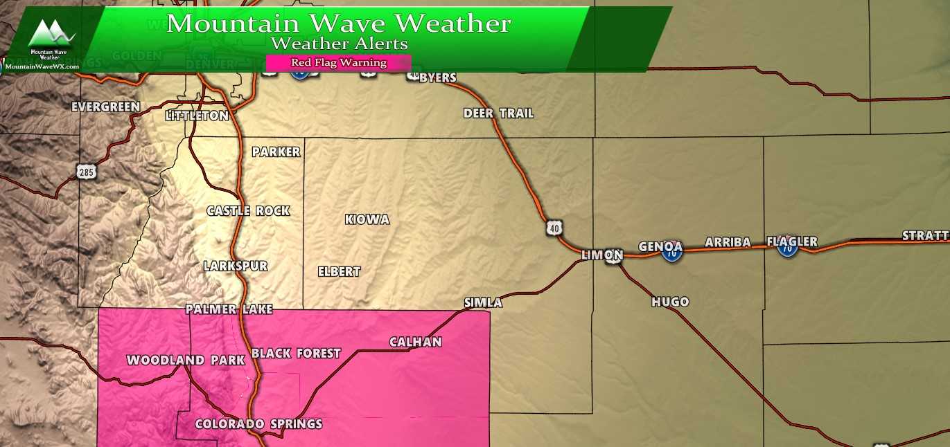
Red Flag Warning areas for extreme fire danger Saturday October 19, 2019
***Red Flag Warning - Saturday 10/19/2019 From 12PM - 8PM ***
Teller County/Rampart Range Including Pikes Peak and Florissant
Fossil Beds National Monument-
Fremont County Including Canon City/Howard/Texas Creek-
San Luis Valley Including Alamosa/Del Norte/Fort Garland/Saguache-
Southern Front Range Including Sangre De Cristo Mountains/Wet
Mountains/La Veta Pass-
Northern El Paso County Including Monument and Black Forest-
Southern El Paso County Including Fort Carson and Colorado
Springs-Huerfano County Including Walsenburg-
Western Las Animas County Including Trinidad and Thatcher-
409 AM MDT Sat Oct 19 2019

...RED FLAG WARNING REMAINS IN EFFECT FROM NOON TODAY TO 8 PM MDT
THIS EVENING FOR GUSTY WINDS AND LOW RELATIVE HUMIDITY
* Winds...Saturday southwest 15 to 25 with gusts to 40mph. Sunday
  west 20 to 30 mph with gusts up to 55 mph.

* Timing...Noon Saturday through 8 PM Saturday evening for the
  Red Flag Warning, late Sunday morning through Sunday evening for
  the Fire Weather Watch.

* Relative Humidity...5 to 10 percent.

* Impacts...Conditions will be favorable for the rapid ignition,
  growth and spread of fires.

PRECAUTIONARY/PREPAREDNESS ACTIONS...

A Red Flag Warning means that critical fire weather conditions
are either occurring now, or will shortly. A combination of
strong winds, low relative humidity, and warm temperatures can
contribute to extreme fire behavior.
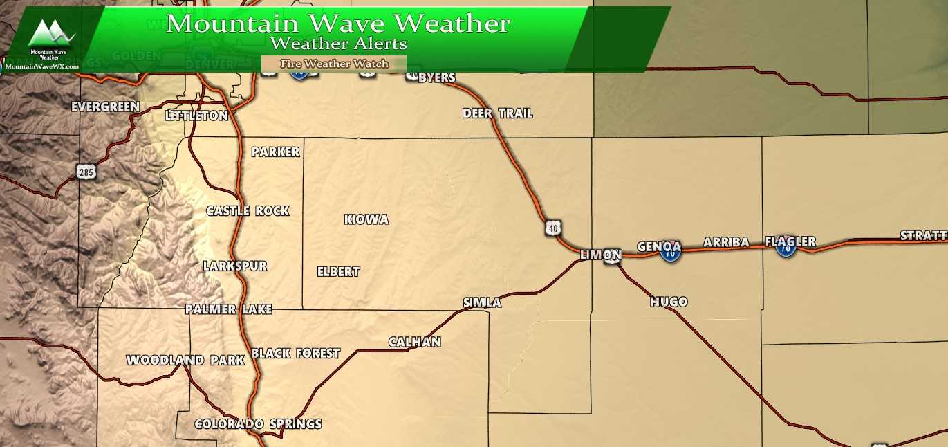
Fire Weather Watch outline area for Sunday October 20, 2019
***Fire Weather Watch - Sunday 10/20/2019 From 10AM - 8PM ***
North Douglas County Below 6000 Feet/Denver/West Adams and
Arapahoe Counties/East Broomfield County-
Elbert/Central and East Douglas Counties Above 6000 Feet-
Central and East Adams and Arapahoe Counties-
North and Northeast Elbert County Below 6000 Feet/North Lincoln
County-
Southeast Elbert County Below 6000 Feet/South Lincoln County-
535 AM MDT Sat Oct 19 2019

...FIRE WEATHER WATCH REMAINS IN EFFECT FROM SUNDAY MORNING
THROUGH SUNDAY EVENING FOR WIND AND LOW RELATIVE HUMIDITY FOR THE
EAST CENTRAL PLAINS OF COLORADO ALONG AND SOUTH OF THE
I-70 CORRIDOR...

* Winds...Northwest 20 to 30 mph with gusts up to 40 mph.

* Timing...Mid morning Sunday through early Sunday evening.

* Relative Humidity...As low as 16 percent.

* Impacts...The strong winds in combination with low humidities
  under 20 percent will allow for quick spread of any grassland
  fires. Open burning should not occur before or during these
  conditions on Sunday.

PRECAUTIONARY/PREPAREDNESS ACTIONS...

A Fire Weather Watch means that critical fire weather conditions
are forecast to occur. Listen for later forecasts and possible
Red Flag Warnings.
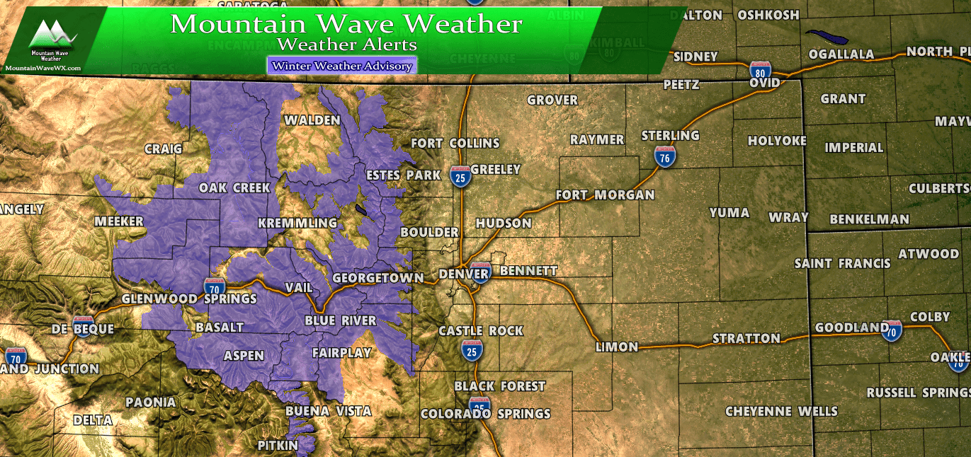
Travel conditions in the mountains could be hazardous from late tonight through Sunday afternoon. Be prepared if you are moving through these areas, strong winds and heavy snow could be possible at higher elevations.
***Winter Weather Advisory - Sunday 10/20/2019 From 12AM - 12PM ***
URGENT - WINTER WEATHER MESSAGE
National Weather Service Denver CO
339 AM MDT Sat Oct 19 2019

...SNOW, GUSTY WINDS, AND BLOWING SNOW HEADED FOR THE MOUNTAINS...

.Snow, winds, and blowing snow will increase from west to east
across the northern mountains of Colorado tonight. Snow will be
heaviest late Saturday night into early Sunday morning, before
decreasing by Sunday afternoon and evening. People planning travel
across the Colorado high country should be prepared for hazardous
winter travel conditions, including snow covered roads and
reduced visibility.

COZ033-034-191745-
/O.CON.KBOU.WW.Y.0030.191020T0600Z-191020T1800Z/
Rocky Mountain National Park and the Medicine Bow Range-
The Mountains of Summit County, the Mosquito Range, and the
Indian Peaks-
Including the cities of Cameron Pass,
Laramie and Medicine Bow Mountains, Rabbit Ears Range,
Rocky Mountain National Park, Willow Creek Pass, Berthoud Pass,
Breckenridge, East Slopes Mosquito Range,
East Slopes Southern Gore Range, Eisenhower Tunnel, Indian Peaks,
Kenosha Mountains, Mount Evans, Williams Fork Mountains,
and Winter Park
339 AM MDT Sat Oct 19 2019

...WINTER WEATHER ADVISORY REMAINS IN EFFECT FROM MIDNIGHT
TONIGHT TO NOON MDT SUNDAY...

* WHAT...Snow expected. Total snow accumulations of 3 to 8
  inches. Winds gusting as high as 55 mph.

* WHERE...Rocky Mountain National Park and the Medicine Bow
  Range and The Mountains of Summit County, the Mosquito Range,
  and the Indian Peaks.

* WHEN...From midnight Saturday night to noon MDT Sunday.

* IMPACTS...Plan on slippery roads and hazardous travel
  conditions. Areas of blowing snow could significantly reduce
  visibility.

PRECAUTIONARY/PREPAREDNESS ACTIONS...

Slow down and use caution while traveling.

The latest road conditions for the state you are calling from can
be obtained by calling 5 1 1.
Closer to Home...
The main story for us this weekend along the Palmer Divide region will be the extremely dry conditions and the high winds. It doesn't look to be the most windy conditions most of us have seen, but it will be quite blustery at times late Saturday and into Sunday.
Two main impacts from wind coming up over the next 48 hours...
- Saturday
- 8PM - 12AM Sunday
- Wind gusts up to 35MPH
- Strongest winds East of I-25 corridor and into Elbert County
- Winds will be lighter for Castle Rock and areas along I-25
- Strong winds possible between Larkspur and Monument after midnight
- Sunday
- 5AM - 1PM
- Wind gusts up to 45MPH
- Strongest winds establish early in the morning across the entirety of the Palmer Divide
- Strongest wind gusts in Elbert, Eastern Douglas and Northern El Paso Counties
- Strong winds will be present most of the morning and will begin to subside after noon
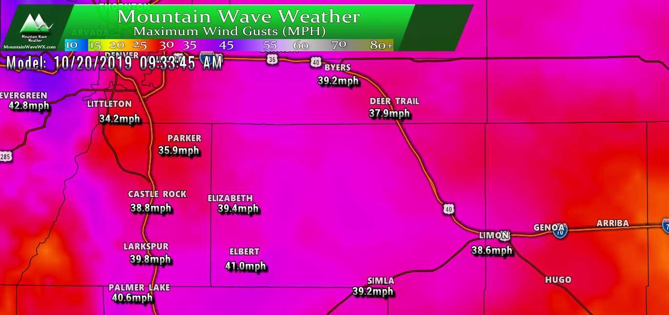
Peak Wind gusts around 9:30AM. Some models show a stronger burst of winds between 5-7AM for Western Elbert County
Any Chance for Rain or Snow?
There is the tiniest chance of seeing a sprinkle or snow flake along the Palmer Divide late Saturday into early Sunday but the chance is so small I don't know if it's worth discussing much. I'd place the probability somewhere south of 5%.
Most of the snow will stay up in the mountains and the areas right along the Continental Divide should see some decent accumulation.
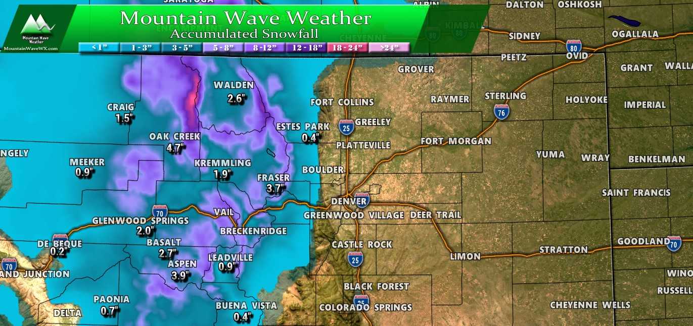
Looks like some areas could see up to a foot, great news for our ski areas as they kick the early season off!
Summary
Wrapping it all up, nothing too exciting for us around here at lower elevations. Looks like the same old story of lots of wind and very little moisture which isn't great news for our drought situation. I don't see a lot of promising news in the models ahead either, but as we all know that can change over the coming days.
Speaking of which, I will have articles up this week as I go hunting for when our next decent shot of moisture will show up and I'll have updates on our drought status here along the Palmer Divide.
Stay tuned and have a great weekend! Remember, if you see smoke - call 911 right away! The next 2 days are going to be awful for fire conditions.

Thanks John for the forecast!