Our late week storm system is becoming a bit more clear but we still have some unanswered questions that we should get answers to in the next 24 hours or so. Some of the longer and mid range models have shown some consistentenchy but we are still a bit further away before some of the higher resolution models come into play. That's when we begin to see some of the nuances show up for storm systems.
As usual we'll start with any weather watches/warnings/advisories issued as of the writing of this post (I think more will be coming, but we will address those as they come out.)
Watches/Warnings/Advisories (as of 6PM Mon Oct 7, 2019)
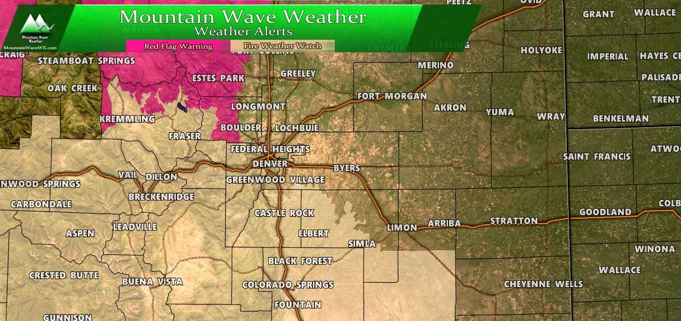
***Fire Weather Watch*** - Includes Palmer Divide
South and Southeast Grand/West Central and Southwest Boulder/
Gilpin/Clear Creek/Summit/North and West Park Counties Above
9000 Feet-Grand and Summit Counties Below 9000 Feet-
Central and Southeast Park County-
Jefferson and West Douglas Counties Above 6000 Feet/Gilpin/Clear
Creek/Northeast Park Counties Below 9000 Feet-
Elbert/Central and East Douglas Counties Above 6000 Feet-
Southeast Elbert County Below 6000 Feet/South Lincoln County-
558 PM MDT Mon Oct 7 2019

...FIRE WEATHER WATCH REMAINS IN EFFECT WEDNESDAY AFTERNOON FOR
WIND AND LOW RELATIVE HUMIDITY FOR THE CENTRAL AND SOUTHERN
MOUNTAINS...MIDDLE PARK...SOUTH PARK AND THE PALMER RIDGE|...

* Affected Area...Fire Weather Zones 212...213...214...216...
  241 and 247.

* Winds...Southwest 10 to 25 mph with gusts up to 50 mph.

* Timing...Wednesday from Noon through 6pm MDT.

* Relative Humidity...As low as 12 percent.

* Impacts...Conditions will be favorable for the rapid ignition,
  growth, and spread of fires.

PRECAUTIONARY/PREPAREDNESS ACTIONS...

A Fire Weather Watch means that critical fire weather conditions
are forecast to occur. Listen for later forecasts and possible
Red Flag Warnings.
Jackson County Below 9000 Feet-
Larimer and Boulder Counties Between 6000 and 9000 Feet-
West Jackson and West Grand Counties Above 9000 Feet-
South and East Jackson/Larimer/North and Northeast Grand/
Northwest Boulder Counties Above 9000 Feet-
558 PM MDT Mon Oct 7 2019

...RED FLAG WARNING REMAINS IN EFFECT FROM 10 AM TO 6 PM MDT
TUESDAY FOR WIND AND LOW RELATIVE HUMIDITY FOR THE NORTHERN
MOUNTAINS...NORTHERN FOOTHILLS AND NORTH PARK...
...RED FLAG WARNING IS CANCELLED FOR WIND AND LOW RELATIVE
HUMIDITY FOR THE NORTHERN MOUNTAINS...NORTHERN FOOTHILLS AND
NORTH PARK...

The National Weather Service in Denver has cancelled the Red Flag
Warning for today. A Red Flag warning will remains in effect for
Tuesday afternoon.

* Affected Area...Fire Weather Zones 211...215...217 and 218.

* Winds...Southwest 10 to 20 mph with gusts up to 35 mph.

* Timing...Tuesday from 10am through 6pm MDT.

* Relative Humidity...As low as 4 percent.

* Impacts...Conditions will be favorable for the rapid ignition,
  growth, and spread of fires.

PRECAUTIONARY/PREPAREDNESS ACTIONS...

A Red Flag Warning means that critical fire weather conditions
are either occurring now....or will shortly. A combination of
strong winds...low relative humidity...and warm temperatures can
contribute to extreme fire behavior.
Latest Analysis
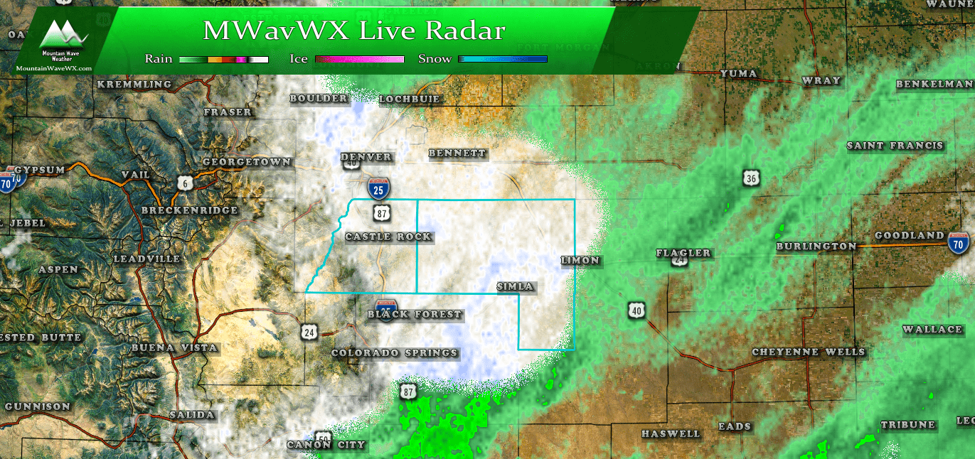
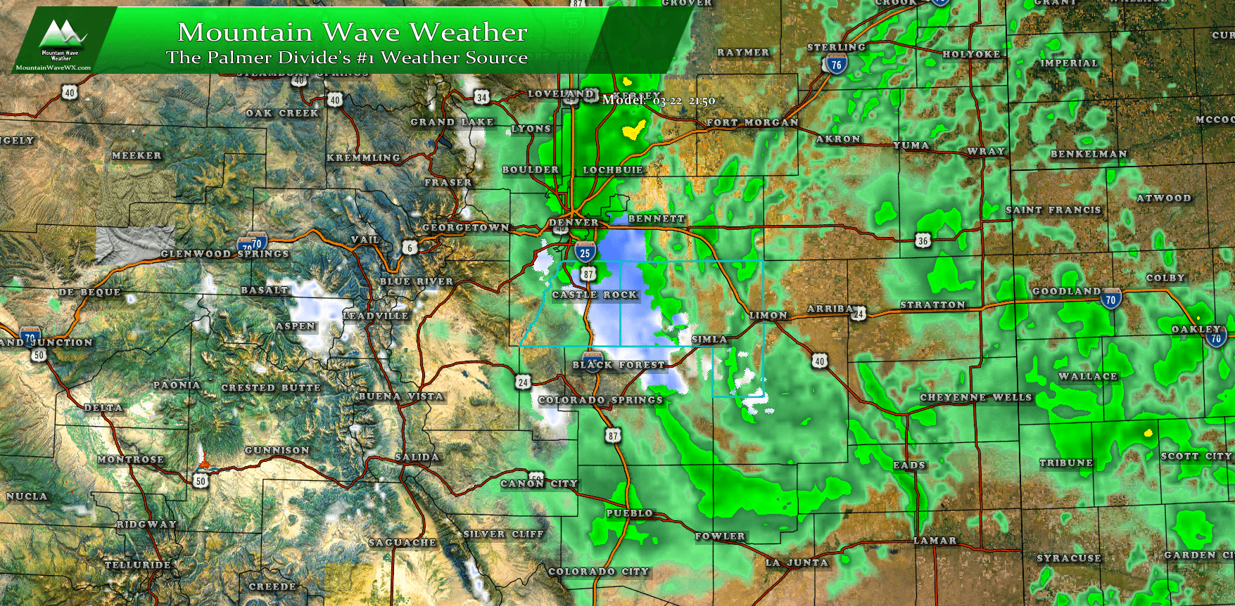
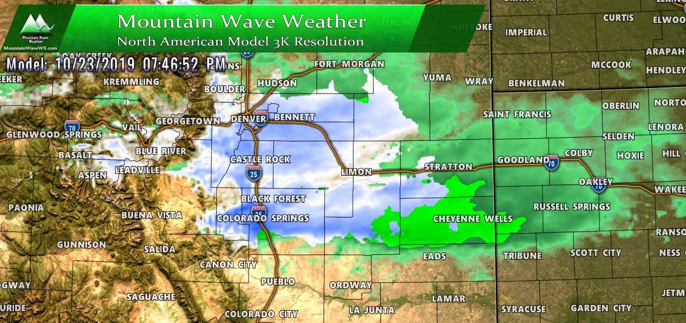
As usual, let's take a look at a few model products. (You can click on these images to make them larger for better viewing)
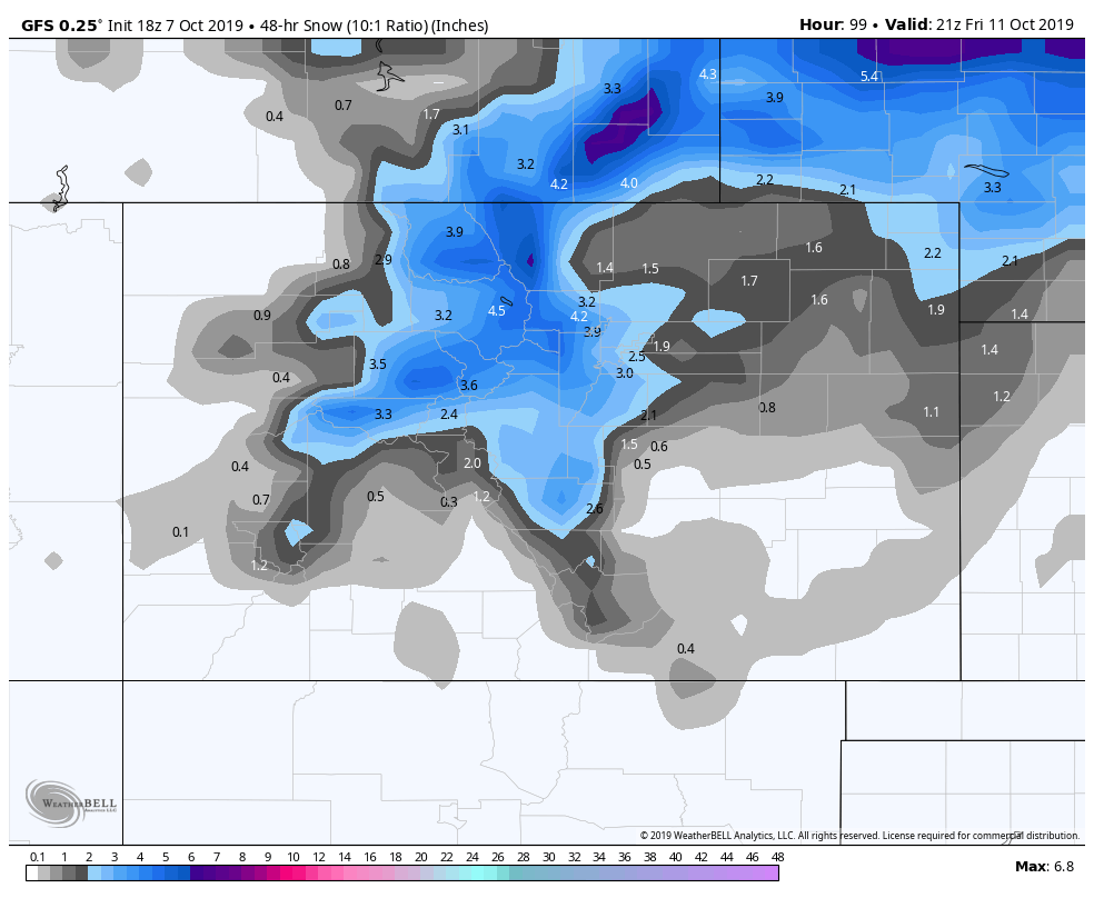
GFS 48 hour accumulated snowfall through 3PM Friday
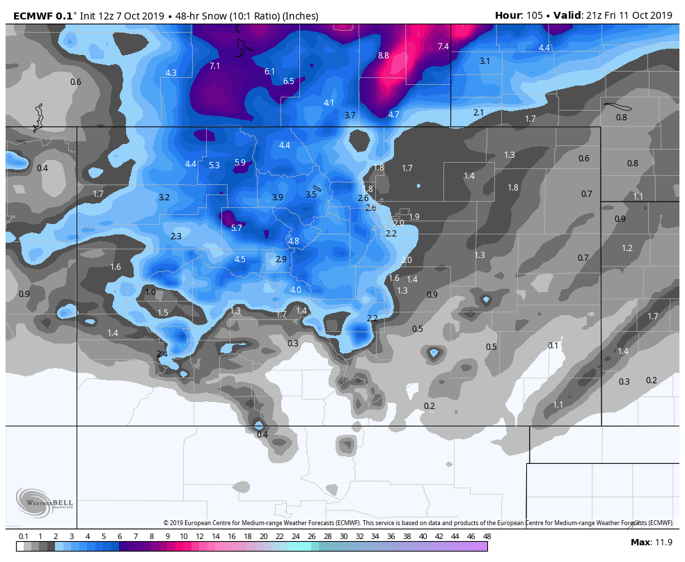
Euro 48 hour accumulated snowfall through 3PM Friday
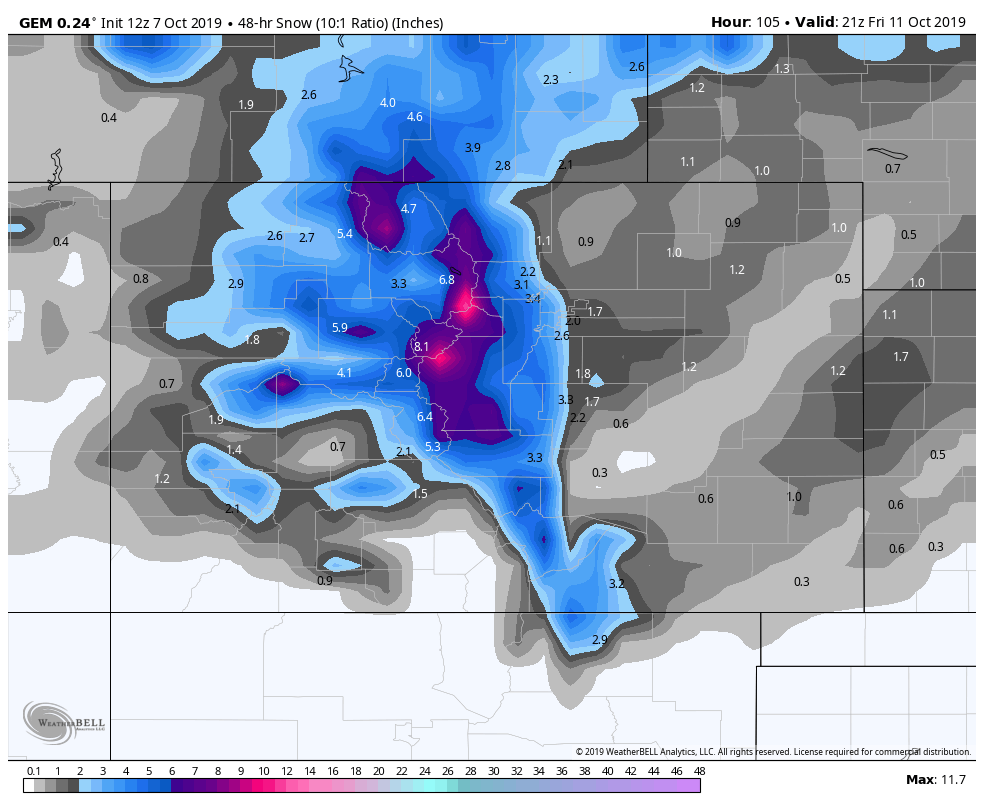
Canadian (GEM) model 48 hour accumulated snowfall through 3PM Friday
Note: the Canadian models (GEM) was the one I threw out yesterday because it was showing crazy snowfall amounts. Given the forecast data and other models I considered it an outlier for yesterday's data, but it has come more in line today. What are these telling us?
For starters, they are all getting pretty close on their solutions, nearly all models are showing some snow accumulation for the front range foothills, plains and Palmer Divide with varying amounts based on location. We can see there's a sharp cutoff which may be models picking up on warmer ground conditions (despite the frigid temperatures) or subtle shifts in the storm track. Unfortunately these lower resolution models can't show us fine details on storm track shifts, that's why we are eagerly waiting for shorter range/ higher resolution models tomorrow.
My biggest concern... and I only need one model to show this (others have varying degrees of cold temperatures but when the EURO is consistent with something I pay attention!)
TEMPERATURES!
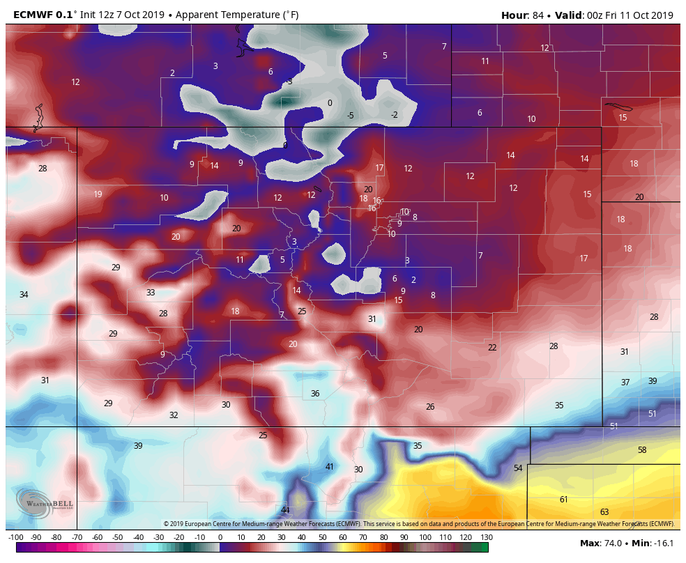
Euro surface temps @ 6PM Thursday evening
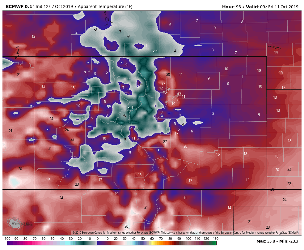
Euro surface temps @ 3AM Friday morning
The temperatures shown above are Apparent Temperatures, so they are what it will feel like to exposed skin based on air temperature, humidity content and winds. As you can see, they are showing extreme cold Thursday night and into Friday morning. I'm especially concerned about the central, southern and eastern sections of the Palmer Divide.
When we see a snapshot of forecast air temperatures at Monument Hill we see verification of extreme cold.
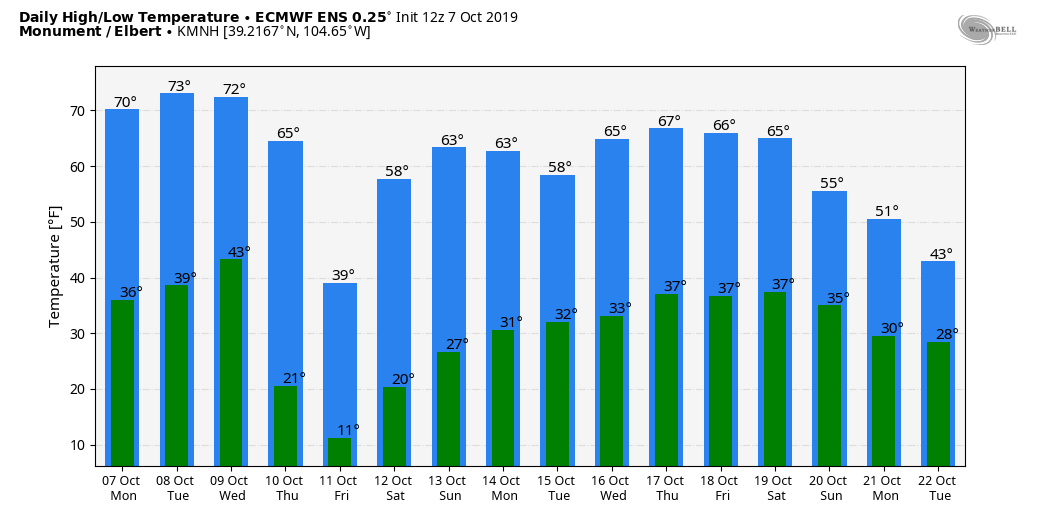
Temperatures in the low teens to upper high digits is in record setting cold territory for this time of year folks. Models show several hours of Hard Freeze conditions meaning plants, animals and exposed plumbing will all have a tough time with the temperatures with this storm. Take Tuesday and Wednesday to prepare yourself, any plants you want to save and any animals (especially those that don't have winter coats on yet) for this arctic blast.
Planning/ Preparation
Impacts
- Extreme cold
- Wind chill temperatures in the single digits are possible. Air temperatures will be in the low to mid teens across most of the Palmer Divide. Some select areas in Northern El Paso County may see wind chills near 0 degrees!
- Prepare any outdoor plumbing, drain above ground sprinklers. If you can't drain them be sure to cover with blankets. The ground will still be relatively warm so it's not imperative that sprinkler systems be blow out just yet. Ensure host faucets are disconnected.
- Snowfall/Travel Impacts
- Possible impacts to Thursday morning and/or Thursday evening commutes. Be prepared for extra time for travelling on Thursday.
- FLASH FREEZE! - Super concerned that initially warm roads will flash freeze with the moisture and cold air moving in. These events can cause the road to ice over in a matter of minutes. Be super cautious on Thursday!
Timing
- Wednesday
- Will be warm during the day. Windy conditions, high temperatures and low dewpoints will mean fire conditions will be high.
- Models currently have the cold front moving through sometime between 6-10PM. Expect strong winds and rapidly dropping temperatures when that happens.
- Thursday
- Thursday morning and/or Thursday evening commute could be impacted.
- Exact timing details are still a but uncertain, some models have a Thursday morning, or Thursday evening event... some have a full day Thursday event. Stay tuned for updates on this.
- Friday
- Ice and snow may still be possible into Friday morning.
- Travel impacts may linger for the Friday morning commute.
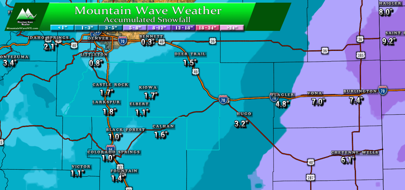
Snowfall
It's a bit early yet but I'll post a very preliminary snowfall forecast. Expect this to change (possibly drastically) over the next 24-48 hours. You'll notice I'm a bit more conservative than some of the news outlets and other sources online. I still am waiting to see how the warm ground is going to play out... models don't always estimate that well and can sometimes over-do snowfall because of it. The other wildcard here is that strong winds may end up negating the warm ground factor... for all of that we will have to see how the models play out in the next day or two.
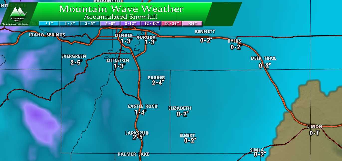
Estimated snowfall through Thursday Evening/ Friday Morning. Preliminary, this will change!
Summary
Quite the little storm we have setting up for October. The huge temperature contrast is going to be a shock for a lot of people so be ready for that. I don't quite know yet if the snow will be a big impact, seems like the biggest impact will be the temperatures and wind.
If you have agriculture interests on the Palmer Divide, be ready to move animals inside during the storm. I know mine don't have their coats in yet so the frigid temperatures may cause problems.
As always, stay tuned for further updates. I'll be sure to post more as we get more data in, like all storm systems this is a rapidly evolving situation so expect some forecast changes over the next day or two based on new data.
That being said; as of right now we are highly confident on the frigid temperatures. We are moderately confident on snowfall of some sort and low/moderate confidence on snowfall accumulations on the ground.
Thanks and stay tuned!
