This update features a whole ton of weather warning information; if you're interested more in the storm analysis; scroll past the warning details... it's towards the bottom of this article.

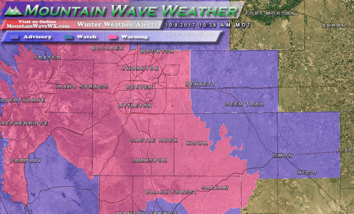
Latest winter weather alerts with expected snowfall amounts as of this morning (Sunday 10/8/2017)
Latest Winter Weather Alert Details
Winter Storm Warning
Areas: Fort Collins, Hereford, Loveland, Nunn, Arvada, Boulder, Golden, Lakewood, Longmont, Aurora, Brighton, City of Denver, Denver International Airport, Highlands Ranch, Littleton, Parker, Castle Rock, Elbert, Fondis, Kiowa, and Larkspur
Duration: 12AM Monday through 3PM Monday
Hazards: Heavy snow expected. Some secondary roads and bridges and
overpasses may become snow or slush covered. Scattered power outages may occur due to
heavy wet snow accumulating on trees still bearing their leaves.
Preparation Actions: Travel is not recommended during the warning, ff you must travel, keep an extra flashlight, food and water in your vehicle in case of an emergency
A Winter Storm Warning for snow means severe winter weather
conditions are expected.
Winter Weather Advisory
Areas: Colorado Springs Vicinity/Southern El Paso County/Rampart Range
Duration: 3AM Monday through 3PM Monday
Hazards: Snow and blowing snow expected. Plan on slippery road conditions at times, including during the morning commute on Monday. In addition, areas of poor visibility are expected.
Preparation Actions: Be prepared for snow covered roads and limited visibility, and use caution while driving.
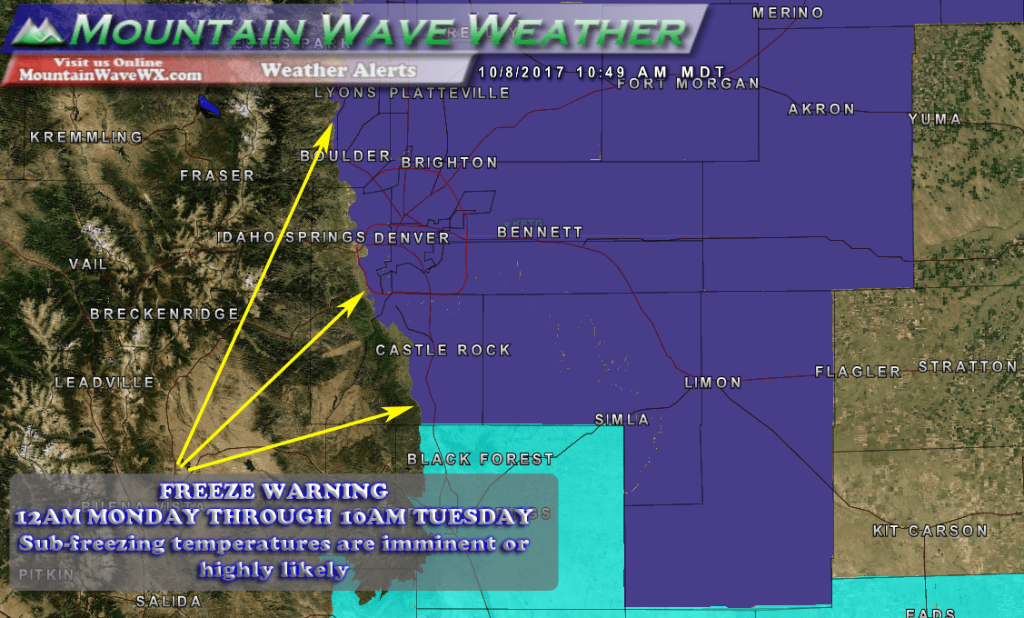
Freeze warnings are also in effect for this storm
Freeze Warning
Areas: Larimer County Below 6000 Feet/Northwest Weld County-
Boulder And Jefferson Counties Below 6000 Feet/West Broomfield
County-North Douglas County Below 6000 Feet/Denver/West Adams and
Arapahoe Counties/East Broomfield County- Elbert/Central and East Douglas Counties Above 6000 Feet-Northeast Weld County-Central and South Weld County-Morgan County-Central and East Adams and Arapahoe Counties-North and Northeast Elbert County Below 6000 Feet/North Lincoln
County-Southeast Elbert County Below 6000 Feet/South Lincoln County-Logan County-Washington County-Sedgwick County-Phillips County
Duration: 12AM Monday through 10AM Tuesday
Hazards: Lows tonight will be near or just below freezing.
Low temperatures Monday night will drop into the mid 20s most
areas.
Preparation Actions: Sensitive vegetation may be damaged by snow and the near freezing temperatures tonight. A hard freeze Monday night will be a killing freeze to most vegetation. Outdoor sprinkler systems should be drained today to prevent damage.
Latest Storm Analysis
Our forecast remains largely unchanged from yesterday as models have come into agreement (mostly) on the snowfall totals they were predicting yesterday. Here's a look at the latest snowfall model runs as of 5AM this morning:
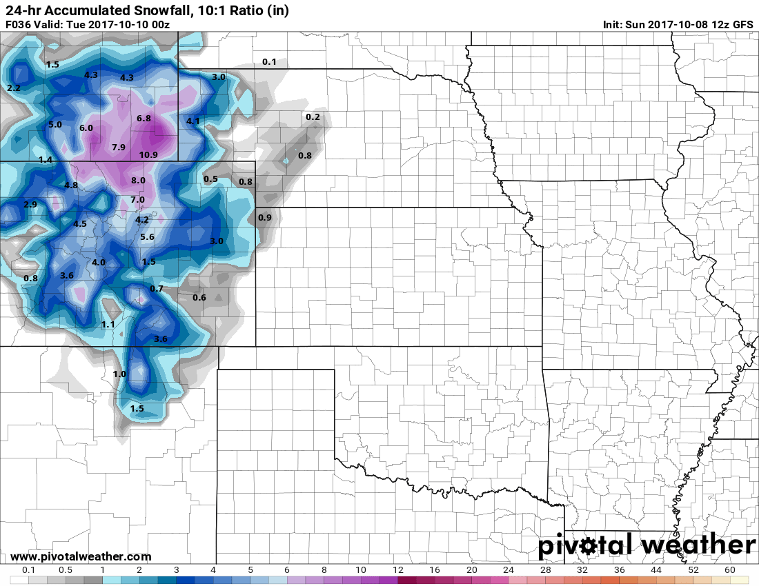
GFS expected snowfall through 5PM Monday
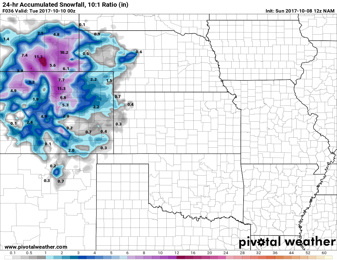
NAM snowfall forecast through 5PM Monday
The SREF ensembles are still on the mark with just shy of 6 inches as well... they haven't budged much since yesterday. So with snowfall models painting a 5-7 inch range, why have we stuck with the 3-7 inch range? The big factor there is that the ground is going to be quite warm and I could see a decent amount of melting happening. Models don't handle those situations well and tend to over-estimate snow accumulations.
That's not to detract from the impacts this storm will have... as always we recommend focusing less on that actual amount of snowfall that falls and more on how it will impact your day on Monday. Travel is going to be rough in some areas, so the Monday morning commute is going to be dicey. Additionally, freezing conditions Monday morning and hard freeze conditions Tuesday morning will be a bit of a shock to those acclimatized to the warm temperatures we've had.
We will have additional updates throughout the day Sunday and into Monday as more data comes in for this storm. Until then, enjoy one last warm and dry day on Sunday!
