Just a quick post regarding the end of the week's storm set to impact Colorado. The storm system is still set to move into Colorado on Thursday with some effects (mainly colder air) lasting into Friday, but some models have been hinting at accumulating snowfall along the front range. Most models agree, if snow does actually stick it looks to be in the areas South of Denver with higher elevations in and along the Palmer Divide.
This Morning's Model Runs for Snow Accumulation
Many of the models show snow beginning sometime during the day and wrapping up in the late night hours on Thursday.
GFS
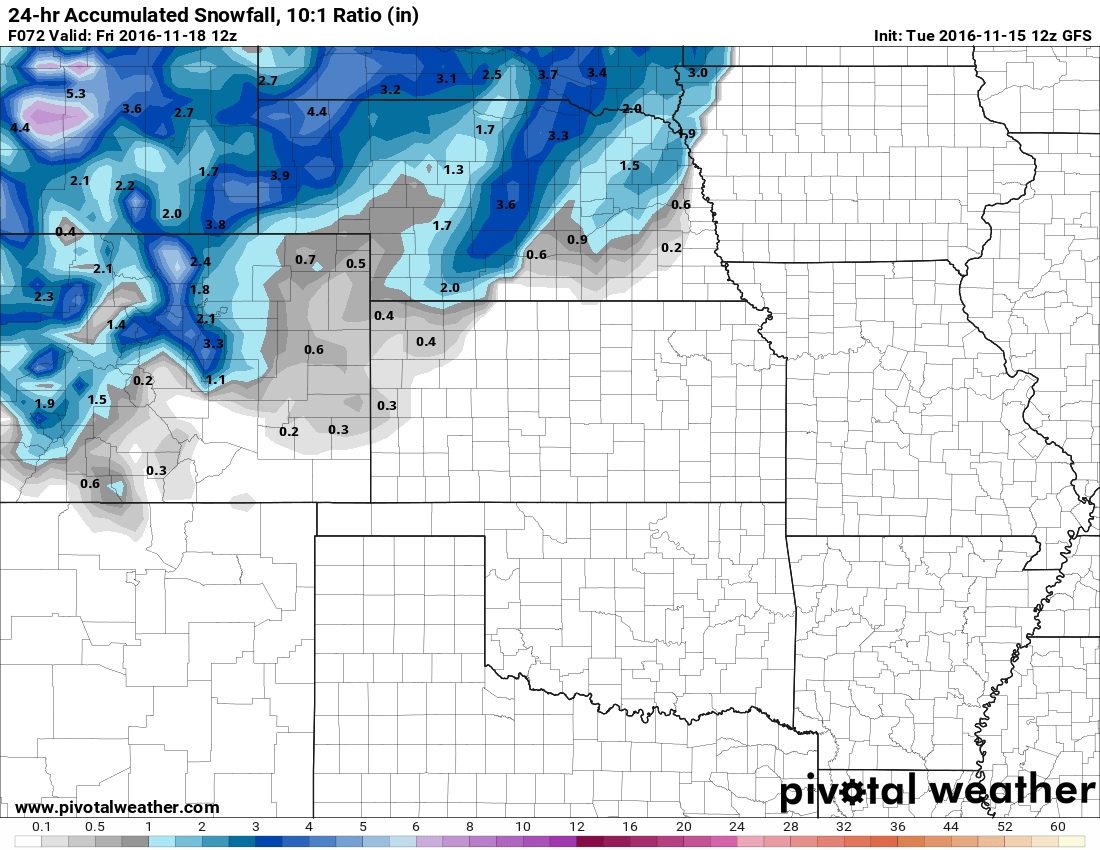
GFS 24 hour accumulated snowfall as of 5AM Friday.
The GFS has been rather bullish since this storm came on the radar but I think it may be a tad overdone. Models can sometimes have trouble with these storms that have cold air right on the fringe of producing snowfall and can miscalculate how much sticks and how much melts. That being said, the GFS has been very consistent in bringing about SOME measurable snowfall, especially in the Palmer Divide area. If you average the last 3 or 4 model runs together the snowfall adds up to about 1.8 inches on average. This morning's model is the first one that showed a higher snow total reaching near 4 inches. Is this model picking up on something or is it having trouble with the temperatures and estimating how much will stick? Time will tell...
NAM
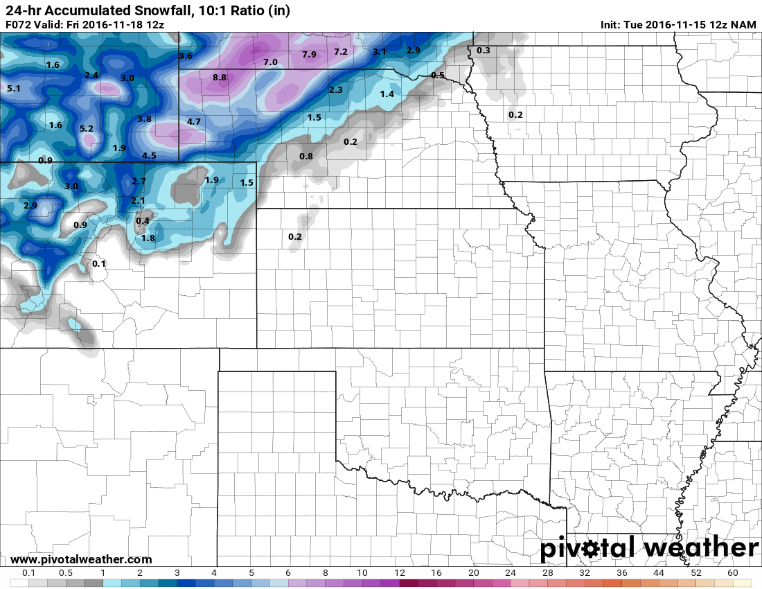
NAM 24 hour accumulated snowfall as of 5AM Friday.
As the NAM is more of a medium range model, it has just come into scope on this storm but has also shown a rather consistent signal for snow. It does however, show considerably less from run to run than the GFS does. Being a medium range model, I tend to put a bit more weight on it as it tends to be a bit more accurate. The GFS does get more accurate in the 1-3 day range as well though so it is something to take in consideration. The NAM in this case shows a similar swath of snow moving across Northeastern Colorado. It tends to favor areas North of the Palmer Divide more leaving the Southern part of the state pretty dry overall.
SREF Ensemble
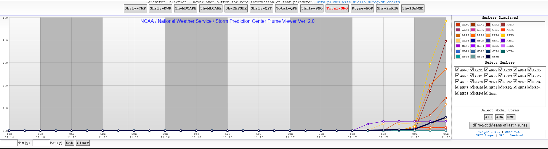
SREF ensemble members total snowfall accumulation
For what it's worth the SREF ensembles show a handful of models with snow accumulation at the Centennial Airport station. The average between all the models lies somewhere around 0.5 to 0.6 inches of accumulation but getting that much would definitely count as measurable snowfall. This would mean we don't quite break the record for latest recorded first snowfall (that day is on Monday.)
Latest Forecast for Castle Rock Based on Current Model Guidance
- Snow begins to fall sometime on Thursday; most likely early afternoon or evening hours. Snowfall should be done by late Thursday night.
- Chance for snow with this storm system as of today: 40-60% chance (average is about 50%)
- Probability is again adjusted upwards based on latest model guidance
- Total Snow Accumulation: 0-1.5 inches
- I still think models are struggling with how much snow melts vs. how much sticks. Any accumulation will be light as I still expect a lot of melting at this time
- Expect clearing on Friday but a very chilly day with highs only in the upper 30's to low 40's. No snow is expected to linger on Friday.
- This storm does not look to be a major snowmaker for Colorado at this point. We are not expecting major travel issues around the Castle Rock area as roads and the ground is still quite warm. We'll keep an eye out in case changes...
As we are getting closer to the storms arrival a lot of models are now starting to pick up on it and a ton of data is coming in. We will be watching this storm closely and I'll be sure to pass along any updates or changes as they become available. Stay tuned!
