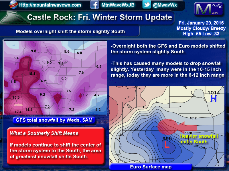
The latest model runs from this morning have shifted our snowfall totals down for the period next week. Most were showing a healthy dose of snow at or over a foot yesterday, most are generally in the 6-12 inch range this morning. There are a couple of factors that seem to support this:
- Models across the board are showing a slight shift to the South of the storm system's center. This would mean a lot of the energy that was expected to hit the Denver area will slide South further. This will diminish our snow totals.
- The high pressure systems to our Northwest and Northeast may not linger long enough to stall this storm out
- If nothing blocks this storm and stalls it over Colorado, it will move more quickly through and exit the state sooner, this would also mean less snowfall.
- There is a large low pressure system to the Northeast over Canada that may also influence this storm, again if this low moves to quickly, our storm will also move quicker.
This is the situation as we see it this morning, it is still worth mentioning that this storm is quite a ways out so this set of model runs is not the end-all be-all.
While I'm on the subject, a quick note about what I like to call "model bounce."
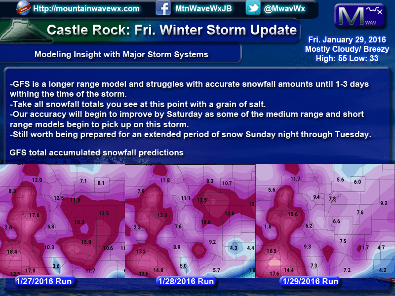
Shown above are 3 GFS model runs in 24 hour increments starting with 1/27 and ending today. You can notice that the first run had Denver around 11 inches, the second bumped it up to 13.5 and as of this morning we are down to about 8.
This is something we see rather often with longer range models when they are still trying to get a grasp on a storm system. The further out we are from the storm, the tougher time the models have at predicting it. The GFS is a nice longer range model, but it struggles with snowfall on many days out from the storm system, so when I show these images please keep in mind that these are more of a guideline of what models believe the atmospheric set will be.
The main point here is still the impact scenario: the snow totals are not super important yet, they won't be anywhere near accurate for a few days anyway. What the models are showing us is that there will be some duration of snowfall across the front range from the Sunday to Tuesday time frame.
At this point, this storm is still 50/50. I have not seen any evidence to support over a foot of snow and no evidence to say we couldn't get 0 inches of snow. It's simply too early to tell!
I'll continue to have updates as this storm evolves, look for my official preliminary snowfall totals sometime on Saturday. Stay tuned!

