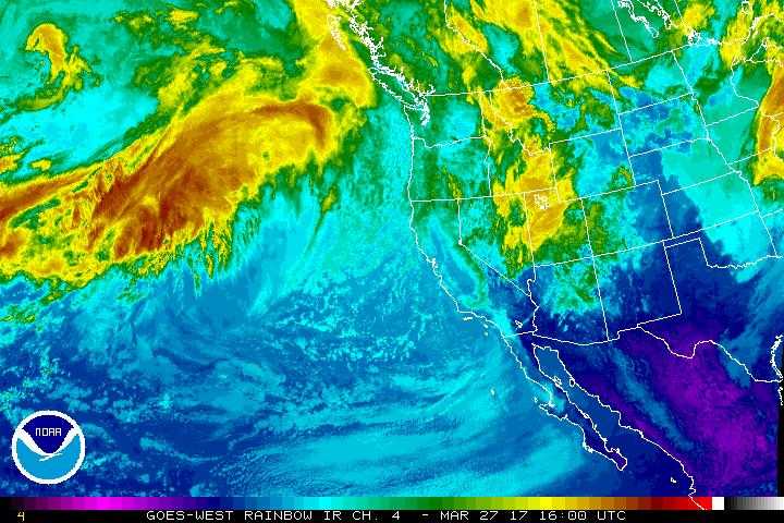
Our weather pattern has officially changed the past week from the warm,dry and stable pattern that we have seen most of the winter. Troughs are beginning to dig further South meaning more storm systems are being funneled our way into Colorado. This week will feature not one, but two strong storm systems moving into the area, but remember the track and intensity will dictate what we do or do not see in terms of precipitation type (rain or snow) and how much if any.
Storm # 1
The first storm system to move into our area will begin impacting the area late in the day on Monday. This storm has a lot of similarities to the last storm we saw in that it has a lot of energy and moisture to work with. Just like the last storm however, there will be a lack of cold air support and where the rain/snow line sets up will dictate who sees snow and who sees rain and how much.
The National Weather Service's latest most likely snowfall map and probablistic snowfall forecast shows how much uncertainty there is with this storm. The graphic below shows the Castle Rock area will most likely see less than 1 inch of snow out of this storm (rain is more likely)
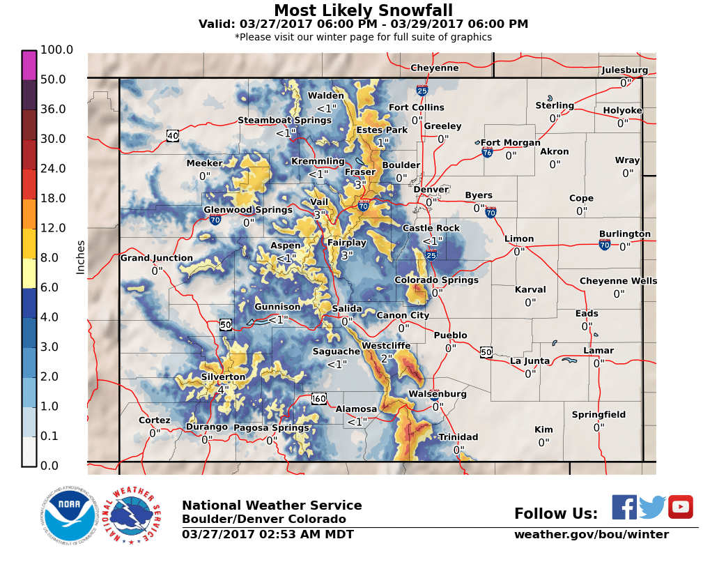
NWS most likely snowfall amount product
But then take a look at the spread on the probabilistic snowfall forecast below...
| For cities in Douglas, CO county |
| Location | At least | Likely | Potential for | 0" | 0.1-1" | 1-2" | 2-4" | 4-6" | 6-8" | 8-12" | 12-18" | >18" |
|---|---|---|---|---|---|---|---|---|---|---|---|---|
| Castle Rock, CO | 0 | 1 | 16 | 22% | 5% | 4% | 10% | 9% | 8% | 15% | 15% | 12% |
| Deckers, CO | 0 | 1 | 16 | 17% | 4% | 6% | 10% | 10% | 10% | 16% | 16% | 11% |
| Franktown, CO | 0 | <1 | 15 | 24% | 4% | 5% | 10% | 9% | 9% | 14% | 15% | 10% |
| Highlands Ranch, CO | 0 | 0 | 15 | 33% | 4% | 4% | 9% | 8% | 7% | 13% | 12% | 10% |
| Larkspur, CO | 0 | 4 | 19 | 12% | 3% | 4% | 9% | 9% | 9% | 16% | 18% | 20% |
| Monument Hill, CO | <1 | 5 | 21 | 10% | 3% | 4% | 8% | 8% | 9% | 16% | 20% | 22% |
| Parker, CO | 0 | <1 | 15 | 31% | 4% | 5% | 9% | 8% | 8% | 13% | 13% | 9% |
| Roxborough Park, CO | 0 | <1 | 20 | 26% | 4% | 3% | 7% | 7% | 7% | 12% | 14% | 20% |
The highest chance for snowfall in Castle Rock (and in many areas) is 0 inches of accumulation, but notice there is an increased chance of snow in the 2-4 inch range and even slightly higher bump in the 8-12 and 12-18 inch range. These are still small probabilities but it is worth noting that trend.
Model Discrepancy
The models are puzzling on this storm system as well, there is a ton of uncertainty and a wide spread of solutions; here's a quick look at the operational models for this storm:
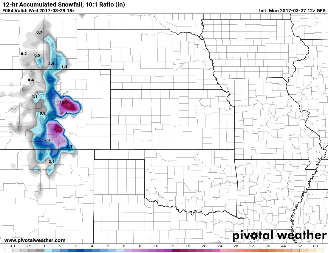
GFS 12 hr snowfall accumulation by noon Wednesday
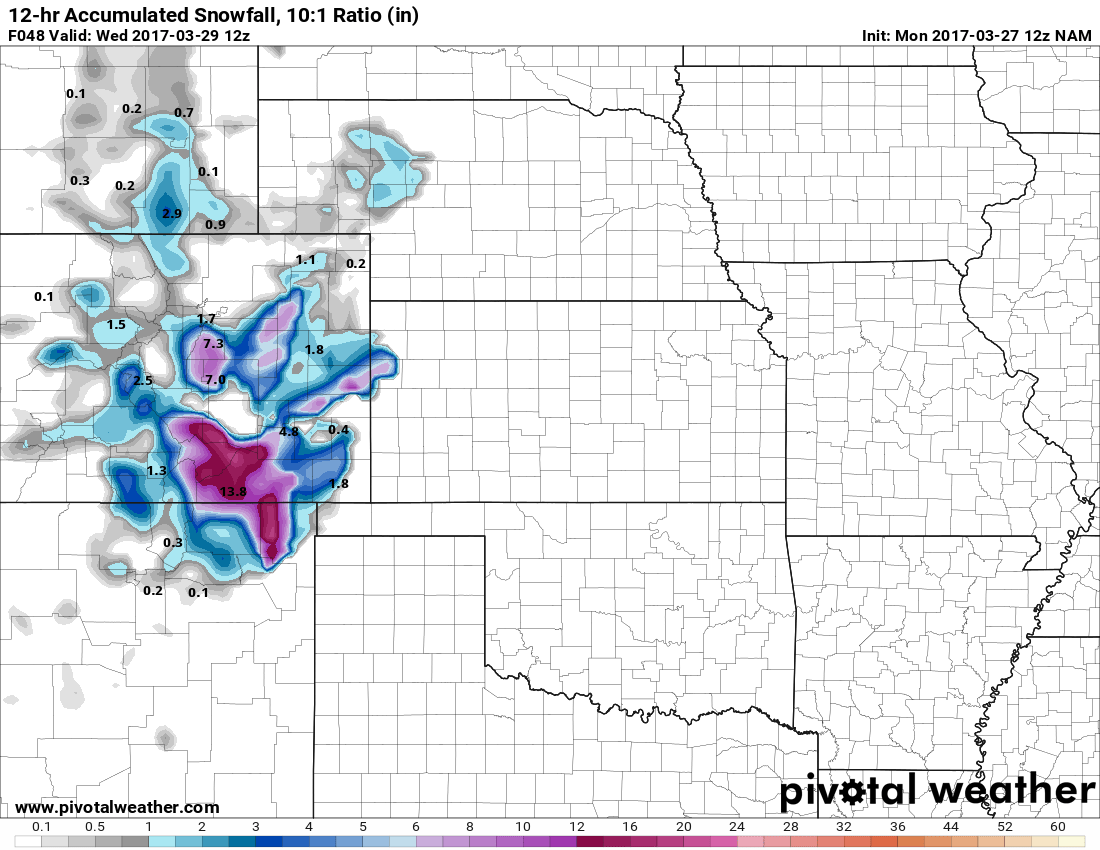
NAM 12 hr snowfall accumulation by 6AM Wednesday
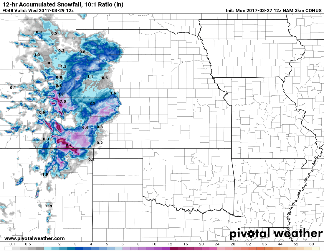
NAM3K 12 hr snowfall accumulation by 6AM Wednesday
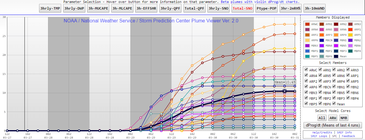
NCEP SREF Ensemble models
Models are pointing to a decent snowfall event with this system but I'm having a tough time believing this due to the lack of cold air support and the storm track, which is expected to swing a bit further South than the last one. Either way, this storm warrants keeping a close eye on... here's a look at our preliminary forecast.
Initial Forecast and Information
**Keep In Mind: Unusually High Level of Uncertainty With Models at This Time**
Timing
- The first wave of this storm system will impact us Monday evening into Tuesday morning.
- Main threat initially will be rain and chance of thunderstorms Monday night and Tuesday morning
- After some afternoon suspension, precipitation will resume later in the day Tuesday (models shows after 3PM)
- Continued precipitation will transition to snow later in the evening hours (6-9PM currently predicted)
- Keep this in mind if you're traveling along the Palmer Divide Tuesday evening, conditions could get tough!
- Heavy snow COULD create difficult travel conditions along the Palmer Divide region late Tuesday night and Wednesday morning!
- Snow generally ends by afternoon on Wednesday.
Snow Accumulations
- Castle Rock and Northern Palmer Divide can expect 0-6 inches total accumulation by Wednesday afternoon
- Castle Rock, Pinery, Franktown, Elizabeth, Kiowa
- Sorry for the wide spread, but until we get better data there is a potential for anywhere between 0-6 inches (or maybe more) of snow accumulation
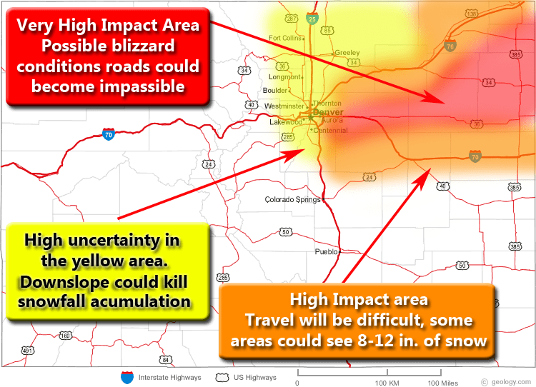
- Areas over and near Monument hill can expect 6-12 inches of accumulation
- Larkspur, Palmer Lake, Monument, Black Forest
- Localized amounts of 7-14 inches will be possible
Wind/Visibility
- Wind is expected to be less of a factor with this storm, but localized aras of gusty winds are possible
- Not expecting blizzard conditions at this time (please stay tuned for updates here in case that changes!)
Impacts
- Heavy snow, along the Palmer Divide region Tuesday night and Wednesday morning could cause difficult travel conditions. I'm most concerned about areas South of Castle Rock!
- Roads are expected to become icy and snowpacked, especially between Castle Rock and Colorado Springs
Stay tuned for more updates on this storm, the forecast will most likely change either way!
Storm # 2
Look for a post up on this storm later in the week with better details as we get more data in. As of right now this storm looks to move into the area in the Friday/Saturday timeframe. Currently this storm is also looking like it could be significant so stay tuned!
Mountain Wave Weather Resources
Stay up to date with our weather information below:
-
Severe Weather Watches/Warnings/Advisories by Mountain Wave Weather
- Custom tailored weather alerts for Castle Rock and the Palmer Divide Region piped in straight from the National Weather Service
-
Significant Weather Page for Palmer Divide Region by Mountain Wave Weather
- Up-to-date forecast information for significant weather events in and around Castle Rock from NWS
-
Real-Time Weather Dashboard for Castle Rock Colorado
- Data straight from our weather station in Castle Rock. Phone apps and TV stations get their data from Centennial Airport, not us!

Simply fantastic!