Advertisements
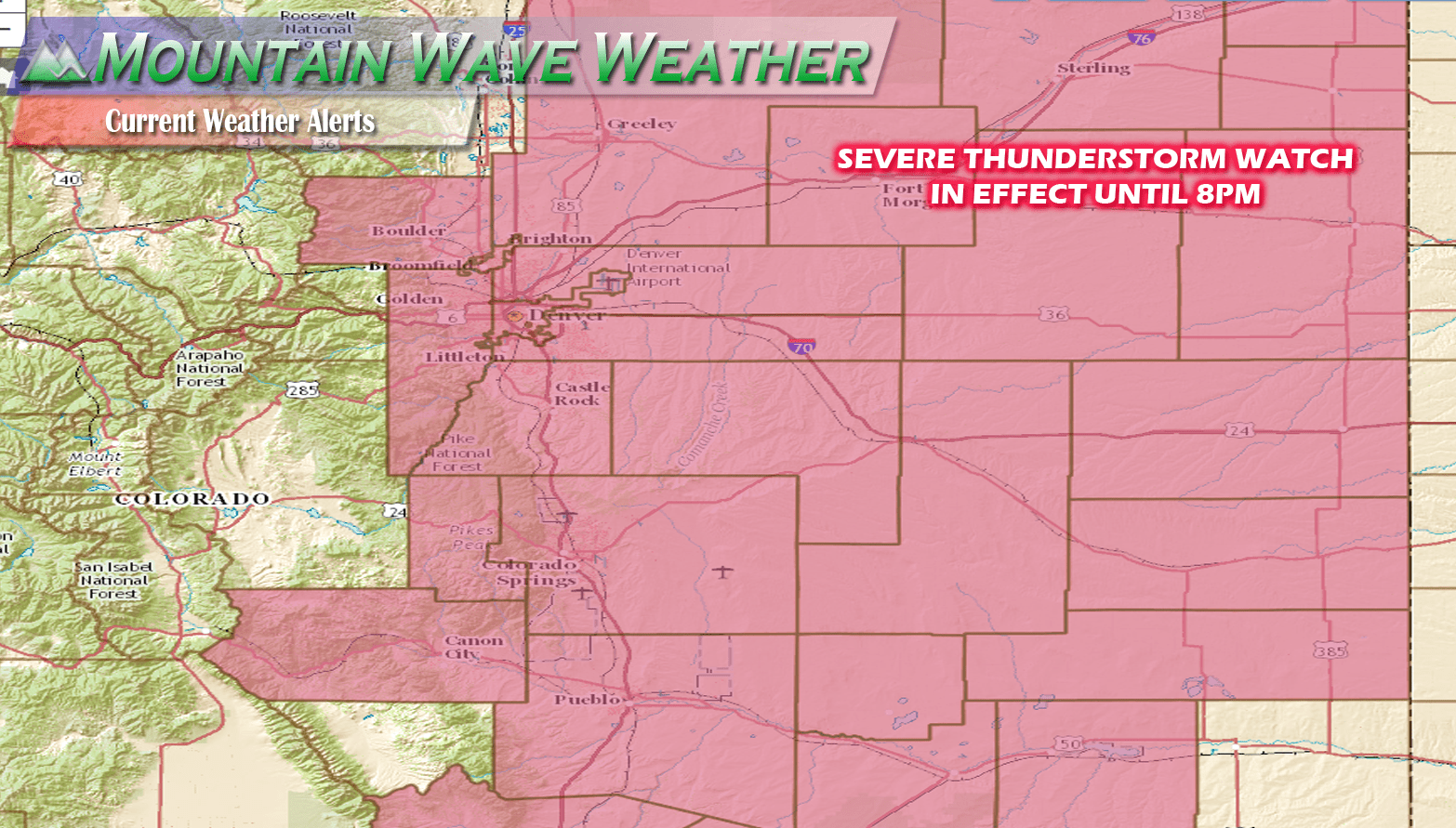
Severe Thunderstorm Watch now in effect with an focused tornado risk along the Palmer Divide and DCVZ zone (meaning Eastern Denver, Aurora, DIA, etc...)
THE NATIONAL WEATHER SERVICE HAS ISSUED SEVERE THUNDERSTORM WATCH
197 IN EFFECT UNTIL 8 PM MDT THIS EVENING FOR THE FOLLOWING AREAS

IN COLORADO THIS WATCH INCLUDES 15 COUNTIES

IN EAST CENTRAL COLORADO

ELBERT                LINCOLN

IN NORTHEAST COLORADO

ADAMS                 ARAPAHOE              BOULDER
BROOMFIELD            DENVER                DOUGLAS
JEFFERSON             LOGAN                 MORGAN
PHILLIPS              SEDGWICK              WASHINGTON
WELD

THIS INCLUDES THE CITIES OF AKRON, BENNETT, BOULDER, BROOMFIELD,
BYERS, CASTLE ROCK, DENVER, FORT MORGAN, GOLDEN, GREELEY,
HOLYOKE, JULESBURG, KIOWA, LIMON, AND STERLING.
Storm Prediction Center Discussion:
SUMMARY...Thunderstorms will develop this afternoon near the higher
   terrain and spread northeastward into the High Plains.  Severe wind
   gusts 60-75 mph are likely with the more intense microbursts.  Large
   hail will accompany the stronger cores, especially early during the
   convective life cycle.  A localized tornado risk is possible near
   the Palmer Divide/Denver Convergence Vorticity Zone.

   DISCUSSION...17z subjective surface mesoanalysis places a cool
   front/wind shift in the vicinity of the Palmer Divide and near the
   El Paso/Elbert County border.  An adequately moist boundary layer
   resides over the CO High Plains with 45-50 degrees F dewpoints.
   Upslope flow to the north of the front and an easterly component to
   the flow south of the front suggest the higher terrain will be
   favored for initial storm development.  Visible satellite imagery
   shows mostly sunny skies with strong heating occurring and a
   swelling cumulus field over the higher terrain.

   Additional heating will further destabilize the airmass as
   surface-500 mb lapse rates reach or locally exceed 9 degrees C/km
   and lead to moderate buoyancy (1000-2000 J/kg MLCAPE).  Moderate
   mid- to high-level southerly flow will result in 25-30 kt effective
   shear south of the front and 30-40 kt north of the boundary.  The
   initial stronger storms will be capable of a large hail/severe gust
   risk.  A risk for a tornado will seemingly focus in the DCVZ
   vicinity before storm coverage substantially increases late this
   afternoon/early evening.  PW around 3/4 inch, a sufficiently strong
   wind profile favoring organized multicells/supercells, very steep
   lapse rates favoring evaporatively cooled downdrafts, coupled with a
   cluster/linearly organized cold pool structure will combine to
   support a substantial risk for scattered severe gusts.  The risk for
   severe gusts will probably maximize during the 22-02z period with
   storm intensity lessening towards the KS/CO border as diurnal
   cooling and a capping inversion lower the overall severe threat.


