Current Weather Watches/Warnings/Advisories
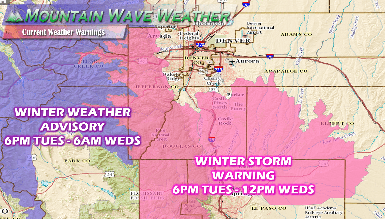
Weather warnings as of 7:00AM MDT
Winter Storm Warning (6PM Tuesday – 12PM Wednesday)
- Western Douglas County foothills, Douglas and Elbert County above 6,000 feet in elevation, Southern areas of Palmer Divide
-
A Winter Storm Warning means significant amounts of snow... sleet...and ice are expected or occurring. This will make travel hazardous or not impossible at times.
- Travel may become difficult in the overnight hours across the Palmer Divide region, especially areas South of Castle Rock to Colorado Springs
What To Expect With This Storm in and Around the Palmer Divide
This specifically means what to expect in Castle Rock, Larskspur, Franktown, Elizabeth, Kiowa, Monument and surrounding areas out towards Limon.
Timing
- Expect a chance of rain and possible thunderstorms across the area during the day Tuesday.
- Precipitation beginsto fill in after 3pm across the front range, starting out mainly as rain.
- Precipitation will transition to snow around 9PM, there will be sharp rain/snow gradient so some areas may take longer to transition to snow.
- Heavy snow and winds will create tough travel conditions overnight Tuesday and into Wednesday morning
- The storm should begin to move out by late Wednesday morning into Wednesday afternoon.
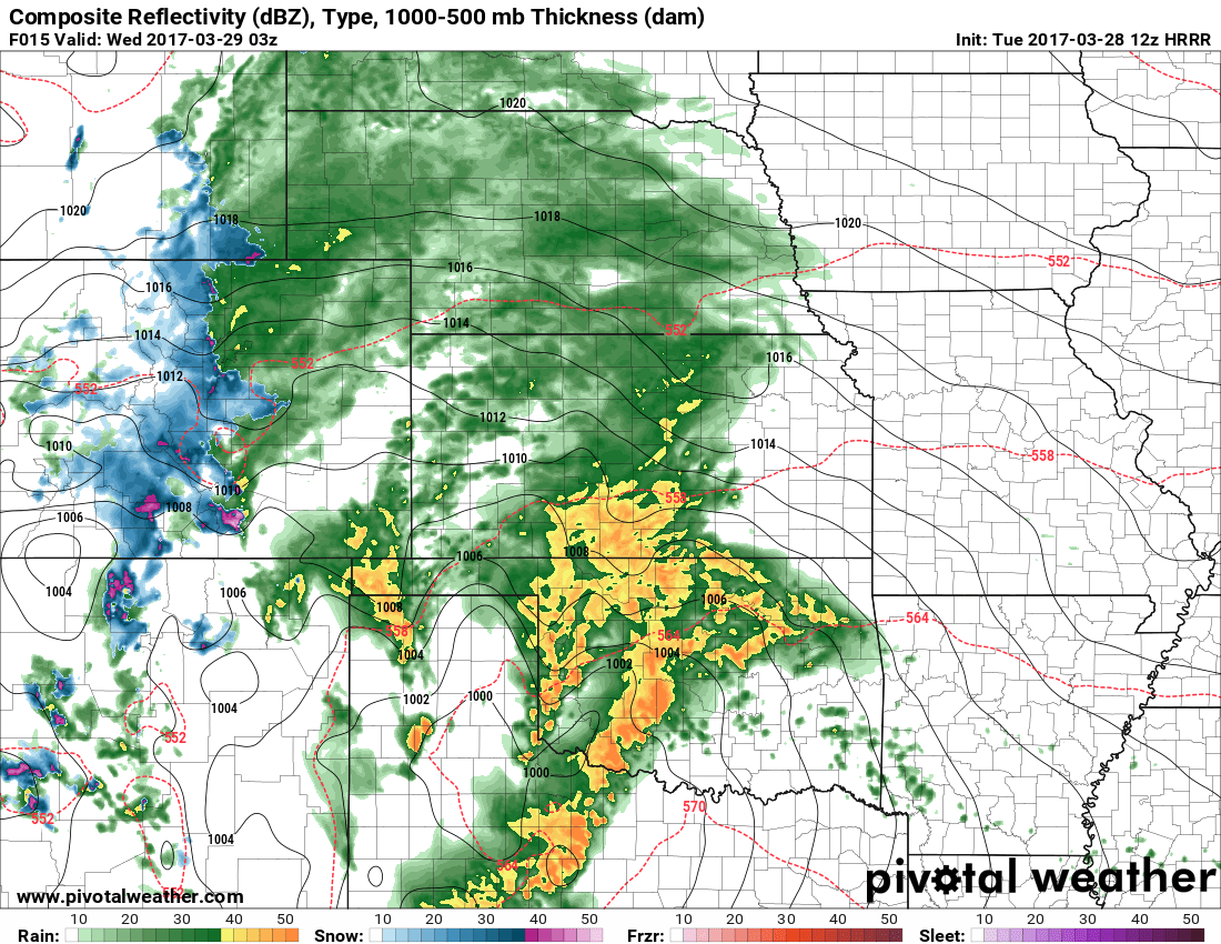
HRRR model snapshot at 9PM Tuesday night
Snow Accumulations
- Castle Rock and Northern Palmer Divide can expect 4-8 inches total accumulation by Wednesday late morning **The rain/snow line is expected to set up just North of Castle Rock so some areas on the North side of town may fall a bit below this range**
- Castle Rock, Pinery, Franktown, Elizabeth, Kiowa
- Areas over and near Monument hill can expect 6-12 inches of accumulation
- Larkspur, Palmer Lake, Monument, Black Forest
- Localized amounts near to above 12 inches will be possible, mainly in areas South of Castle Rock over the Palmer Divide and Monument Hill
Wind/Visibility
- Winds are expected to be slightly less strong as the last storm but they will still be a factor
- Visibility could drop below 1/4 mile in wind-prone areas
Impacts
- Heavy snow, especially after midnight into the early morning hours of Wednesday will make travel difficult. Road closures will be possible in some areas.
- Roads are expected to become icy and snowpacked
- Heavy snow and wind could cause issues with tree branches and powerlines. Sporadic power outages are possible
Summary
Just like the past storm there should be a pretty wide range of snowfall amounts based on where the rain/snow line sets up and how cool our temperatures get.
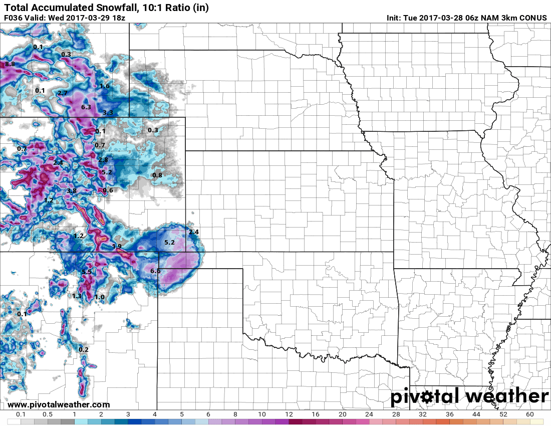
NAM3K snowfall forecast by Weds 12PM
Models are in relatively good agreement on decent snowfall along the Palmer Divide, just as they were on the last storm. The difficult part here is that models can struggle when temperatures are this close to freezing but not quite that cold. We saw this in the last storm where Northern areas of the Palmer Divide saw significantly less snow and more melting than areas just 10-20 miles South.
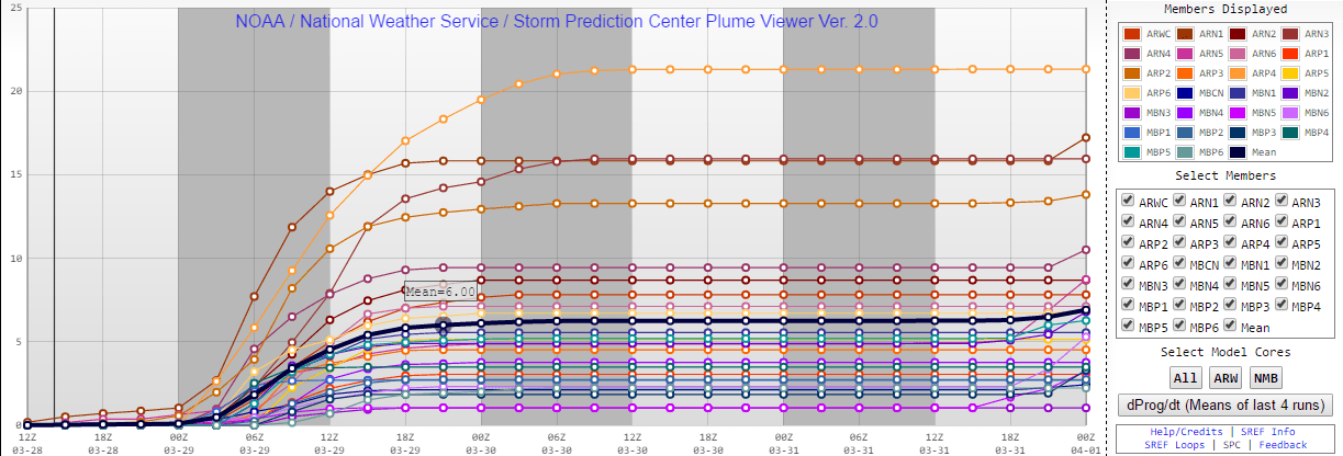
SREF ensembles show a mean of 6 inches by Wednesday afternoon
We will continue to keep an eye on this to see if we have any changes through the day Tuesday. For now, expect a soggy day on Tuesday with mostly rain earlier in the day and snow in the evening. Probably best to have travel wrapped up by no later than 9PM tonight and expect the potential for tough travel conditions on Wednesday morning, especially South of Denver.
Mountain Wave Weather Resources
Stay up to date with our weather information below:
-
Severe Weather Watches/Warnings/Advisories by Mountain Wave Weather
- Custom tailored weather alerts for Castle Rock and the Palmer Divide Region piped in straight from the National Weather Service
-
Significant Weather Page for Palmer Divide Region by Mountain Wave Weather
- Up-to-date forecast information for significant weather events in and around Castle Rock from NWS
-
Real-Time Weather Dashboard for Castle Rock Colorado
- Data straight from our weather station in Castle Rock. Phone apps and TV stations get their data from Centennial Airport, not us!
