This weekend is not going to just be warm, it is going to be borderline hot! A strong ridge in the atmosphere will bring the front range of Colorado southwesterly winds and down-slope conditions, all of which means we will be very warm and very dry this weekend.
Here's a look at what Castle Rock can expect:
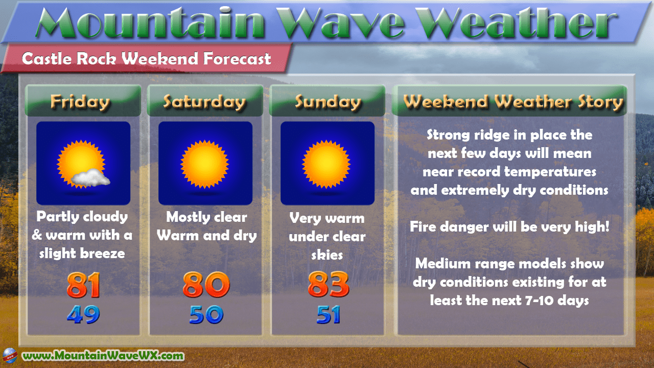
It looks like high temperatures along the front range will remain into the 80's this weekend with the Castle Rock area no exception to that rule. In fact, many areas (Castle Rock included) may tie or even break high temperature records, especially if the high temperatures trend a bit higher.
Here's some average and record temperatures for Castle Rock for reference:
| Date | Average | Average | Record | Record | Average | Average |
| Low | High | Low | High | Precipitation | Snow | |
| 14-Oct | 33° | 66° | 2° (1969) | 84° (1962) | 0.04" | NA |
| 15-Oct | 32° | 66° | 15° (1984) | 82° (1971) | 0.04" | NA |
| 16-Oct | 32° | 65° | 14° (1984) | 82° (1977) | 0.04" | NA |
Source: Intellicast
I think the best chances to break records for high temperatures will be Friday and Sunday. The other thing that will be noticeable will be the warm night-time temperatures. Due to the down-sloping winds, we will expect to see night-time temperatures in the upper 40's and low 50's, well above average as well. In fact, high and low temperatures will be nearly 20 degrees above average for this weekend.
We'll keep an eye out and pass along any new temperature records that are set this weekend.
Why So Warm and Dry?
This weekend continues the longer range pattern we've seen the past few weeks with a strong ridging pattern in the middle and sometimes upper level of the atmosphere. What this does to our weather along the front range depends on the position of the ridge and its strength.
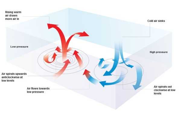
You'll notice on the right (the blue arrows) are the way air acts in a high pressure system. Colder air aloft sinks to the surface and in doing so it warms as it falls in altitude. This is because the air tends to compress as it moves towards the surface as more air piles on top of it.
The effect is twofold; first the air warms up quite a bit but it also dries out. This is why we often see very warm and dry conditions under a high pressure ridge. This is the type of pattern we've seen predominantly over Colorado the past few weeks and explains why we've been so warm and dry.
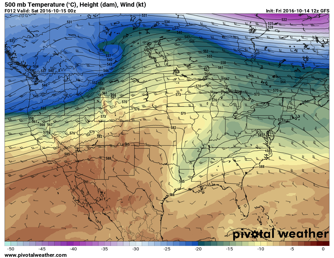
The image above is a look at the forecast 500mb air and temperature for Friday around 6PM. Notice the ridge forming over the Southwestern U.S. and how it draws warm air into the middle levels of the atmosphere. 500mb in altitude is about 18,000 feet above sea level so this is considered a look at the middle and upper levels of the atmosphere. This warm air will move into the area and sink further towards the surface, warming and drying as it does so and the result near the surface for wind and temperatures is this:
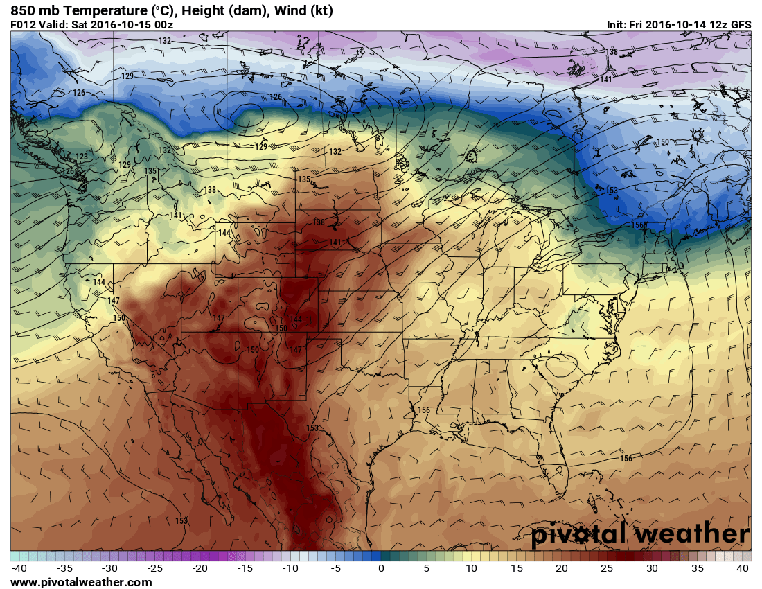
This 850mb chart shows the atmosphere at about the 5,000 feet above sea level altitude so it doesn't represent Denver and Castle Rock too correctly but the overall theme is there. You can see how the air warms further as we move towards the surface. This is due to that sinking and compressing motion from the air in addition to Southwesterly winds transporting additional warm air in from the Southwest.
One more factor is that anytime you have strong Westerly or Southwesterly flow along the front range is a down-sloping affect. This is air moving down the mountains (another sinking motion) that can enhance warming and drying with the air aloft. When all these combine together we see the type of pattern we've seen the past few weeks; warm, dry and windy.
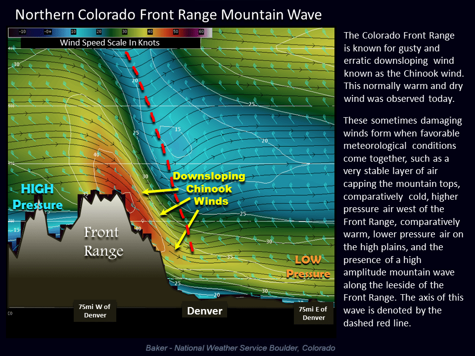
Did you see the mountain wave clouds over the front range today? These clouds form when strong westerly or southwesterly winds aloft get affected by the high terrain West of Denver. This is just one more factor in the weather pattern we've observed the past few weeks and that I describe above.
Hope everyone has a great weekend, enjoy the weather and be careful with fire!


