Snow lovers along the front range of Colorado are getting awfully itchy waiting for a big snowstorm this year. The past couple of storm systems have had the potential to be significant but haven't been able to deliver due to a myriad of factors. As the next storm system begins to move in Friday I'd caution everyone not to underestimate any storm this time of year. Each one of these has had significant potential to drop, not inches but feet of snow but the ingredients haven't quite lined up yet. All it takes is for one of these systems to line up correctly and... you know what happens then, it is after all still March in Colorado!
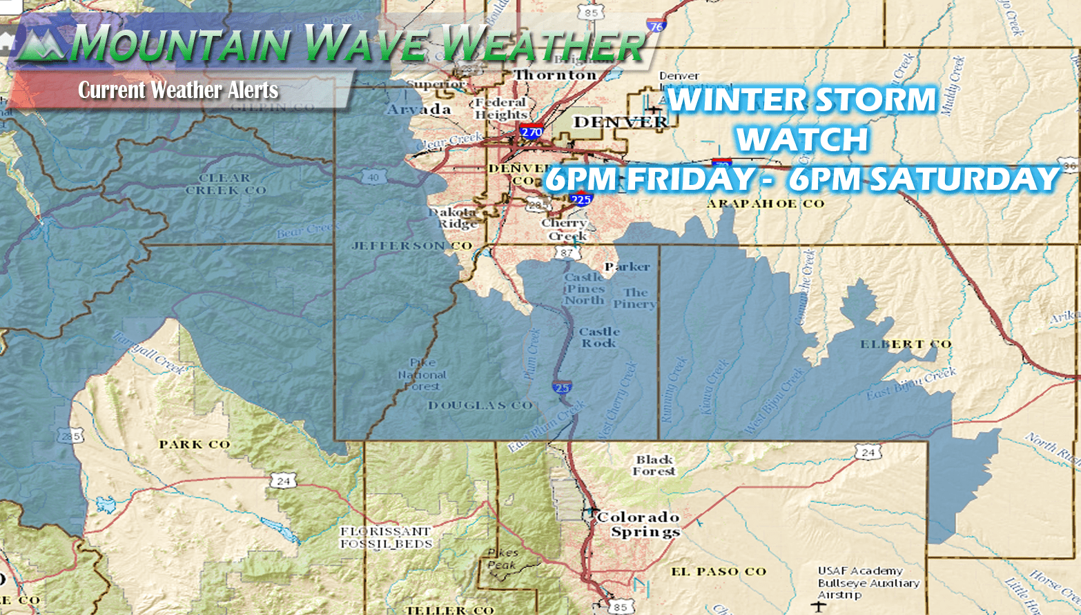
New Winter Storm Watches are up ahead of the next storm system
Winter Storm Watches are now up for the foothills west of Denver, extending into the mountains and along the Palmer Divide. Again, just like the last storms the temperatures will be a contributing factor to who gets rain or snow but as this system has more cold air support, I would not be surpised if Denver gets included in one of these highlights at some point. It will be something to keep an eye on.
A Winter Storm Watch means there is a potential for significant snow...sleet...or ice accumulations that may impact travel. Continue to monitor the latest forecasts.
Tracking the Storm
As with most storm systems this time of year there is not a ton of agreement between models on who gets snow and how much. Interestingly, they all agree on one thing; someone will get a lot of snow! Whether that's us, or only areas South of Castle Rock again or the foothills... it's too early to tell just yet.
Here's a quick look at the latest snowfall forecast from the models in range to this event:
Please Note: These are preliminary operational models and should not be taken as a final forecast on snowfall amounts. These will change within the next 24 hours!
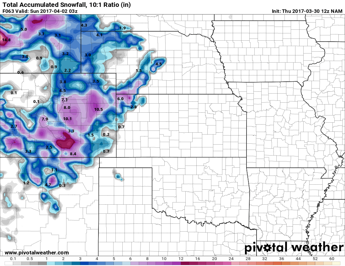
NAM snowfall forecast by storms end on Saturday
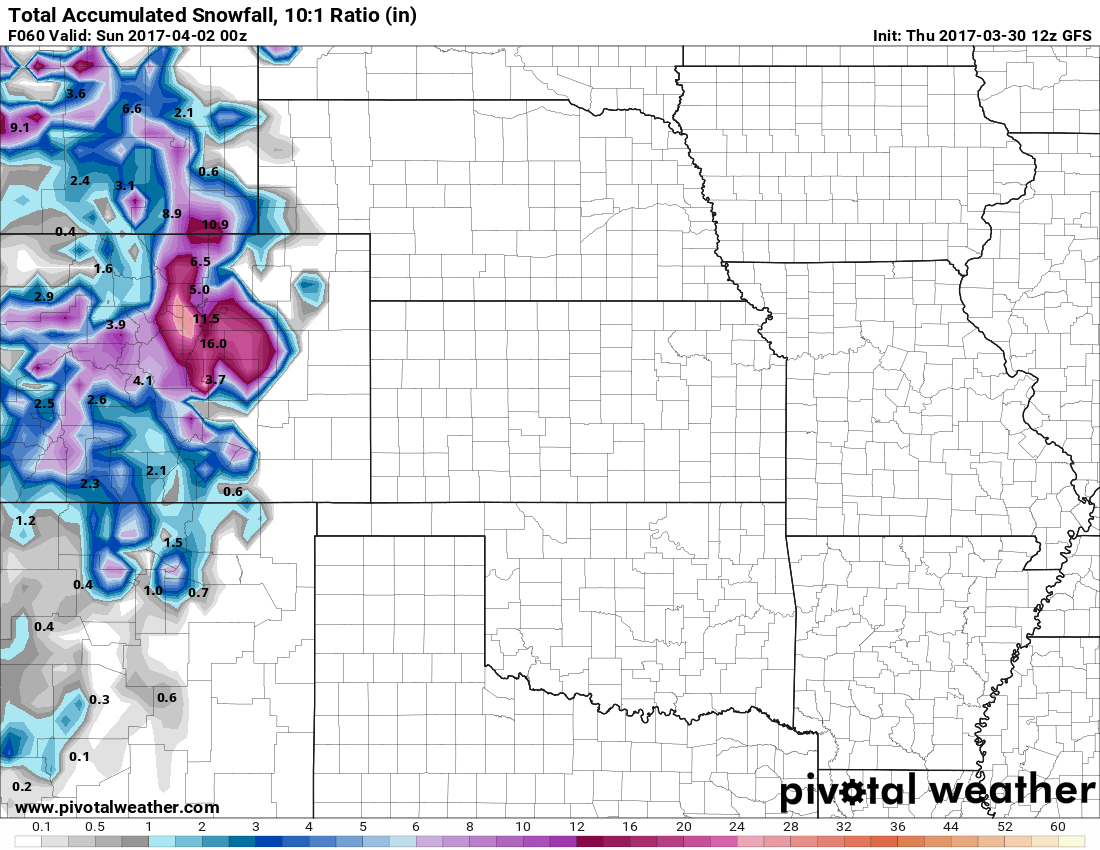
GFS snowfall forecast by Saturday Storm's end
Preliminary Forecast and Impacts
Details are pretty scant right now on snowfall, timing, location and impacts. Expect these details to become more clear in the next 12-24 hours:
Timing
- Rain develops along the front range Friday afternoon.
- Expecting a transition to snow Friday evening, most likely later so not sure if the evening commute will see impact from snow.
- Snow is expected to be heavy overnight Friday into Saturday morning
- Some models show the storm moving out Saturday early afternoon, others show it lingering until Saturday night. We will need more data before we can figure out this timeline.
Snow Accumulations
- Castle Rock and Northern Palmer Divide is currently forecast at 6-12 inches as a mean between models. If we take the outliers we can see anything between 2 inches to 25 inches... those are unlikely amounts at this time though!
- Castle Rock, Pinery, Franktown, Elizabeth, Kiowa
- Areas over and near Monument hill can expect 10-20 inches of accumulation as a mean between models. Keep in mind these are preliminary numbers and will change higher or lower in the next 12-24 hours
- Larkspur, Palmer Lake, Monument, Black Forest
Wind/Visibility
- Still trying to get an idea on what/if any impact winds will have. The stronger the low pressure system is and the tighther the gradient is, the more wind we will see. Keeping an eye on this, stay tuned for updates.
Impacts
- Should models verify expect treacherous travel conditions mainly South of Denver late Friday and a good portion of the day Saturday.
- There is a higher probability Denver and surrounding Metro areas could see more of a snow impact from this storm
- Stay tuned for more details here.
Final Thought
I know after the past few storms it's easy to get complacent about our weather pattern. Models showed big snow on the past two storms but neither delivered significant snow to our area. As I said above, it only takes one storm to tap into all the ingredients to make a big event.
I know details are a bit vague right now, but the point of this article is so people are aware there is a POTENTIAL for a high impact storm this weekend and begin to plan accordingly. If it doesn't pan out, no worries... but if it does you can be prepared!
Stay tuned for updates!
Mountain Wave Weather Resources
Stay up to date with our weather information below:
-
Severe Weather Watches/Warnings/Advisories by Mountain Wave Weather
- Custom tailored weather alerts for Castle Rock and the Palmer Divide Region piped in straight from the National Weather Service
-
Significant Weather Page for Palmer Divide Region by Mountain Wave Weather (UPDATED FOR THIS STORM)
- Up-to-date forecast information for significant weather events in and around Castle Rock from NWS
-
Real-Time Weather Dashboard for Castle Rock Colorado
- Data straight from our weather station in Castle Rock. Phone apps and TV stations get their data from Centennial Airport, not us!
