As I arrived home late this evening I've been looking at the latest model runs and found it pertinent to post a quick update.
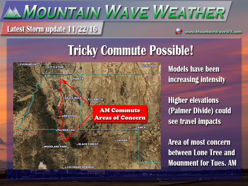
Across the board, models have been shifting snowfall totals up and combined with stronger winds could make for a "Flash Freeze" and snowfall situation similar to what we saw with the storm system last week. With that, I am concerned the Tuesday morning commute will be pretty tricky, especially for areas South of Denver.
Latest Snowfall Models
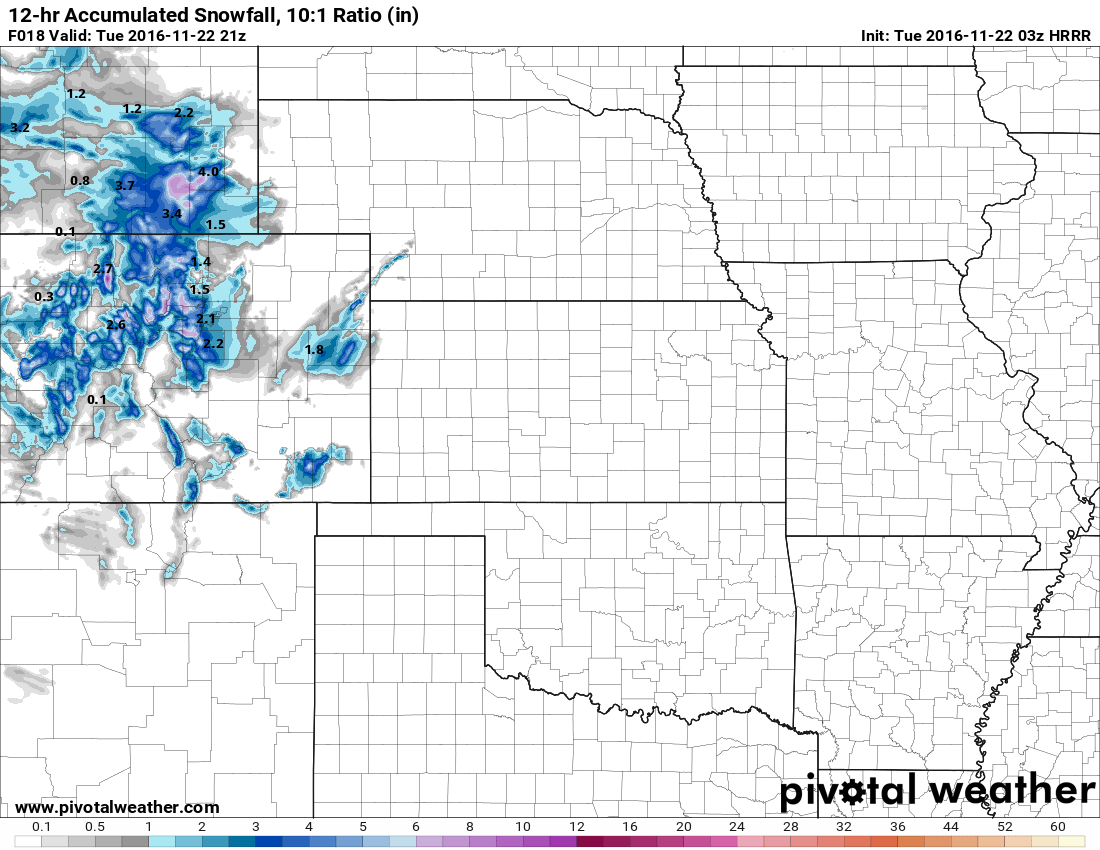
HRRR now showing 2.2 inches of accumulation by noon.
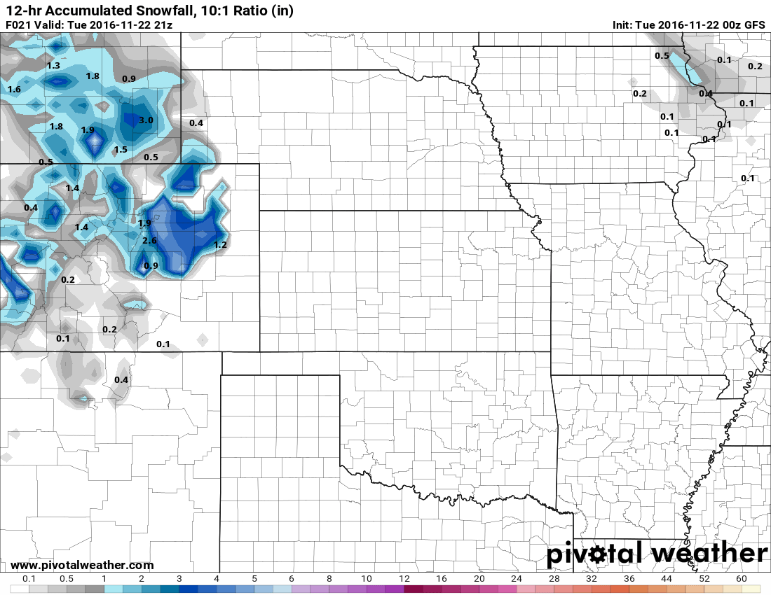
GFS now shows 2.6 inches of accumulation for the Castle Rock area by noon Tuesday.
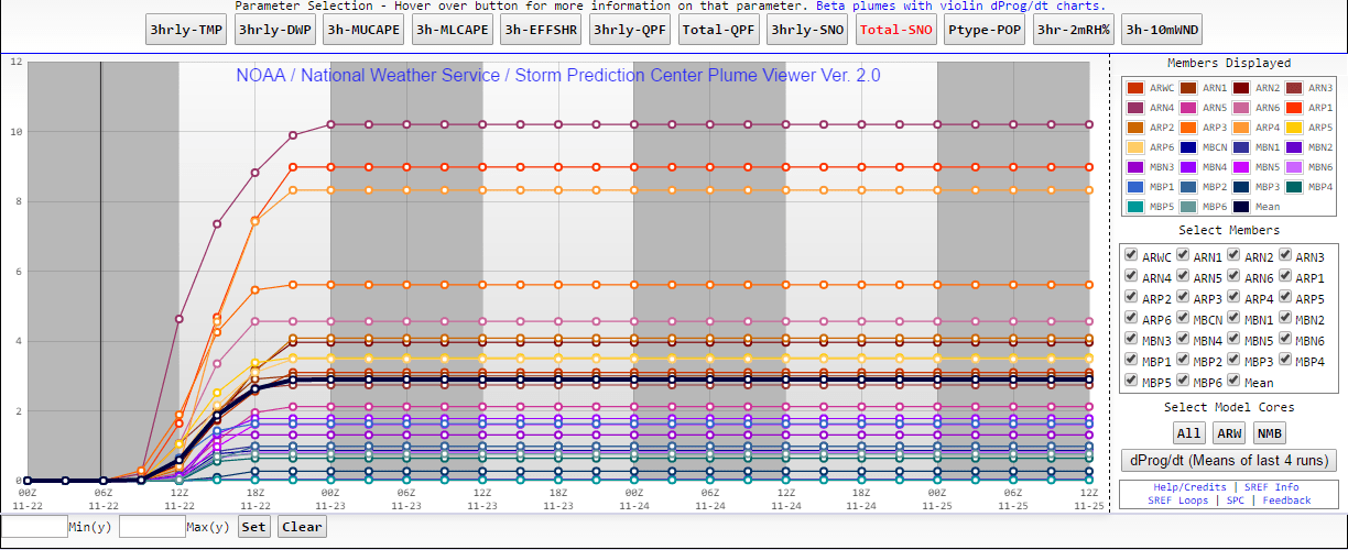
SREF is on board with snowfall between 2-4 inches by noon Tuesday.
Tuesday Morning Commute Could Be Slick
- Precipitation may start as rain in the late night hours of Monday into early Tuesday morning. Models have intensified the storm a bit so light to moderate snow will be possible in the morning hours. At this time, the best chance for snow looks to be between the hours of 4AM-10AM but expect snow to linger a bit outside those times depending on the speed of the storm.
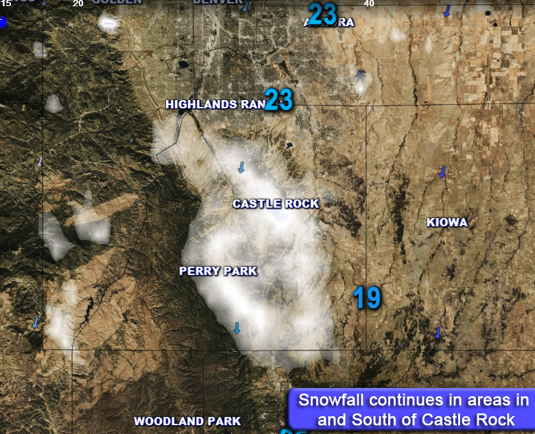
- Model agreement at this time is on 2-4 inches of total snowfall by Tuesday mainly along the Palmer Divide. Areas between Lone Tree and Monument will be the ones that need the closest watching. Heavier snowfall could mean the roads ice up at some point making for tricky travel conditions in the morning hours on Tuesday.
- Snow looks to end in the late morning to early afternoon hours on Tuesday. Clearing will be possible later in the day.
- Temperatures don’t look to get quite as cold with this system so the roads should be ok for most areas in and around Denver. Areas along the Palmer Divide will need to be closely watched for icy conditions. Please be aware of the road conditions and slow down if necessary.
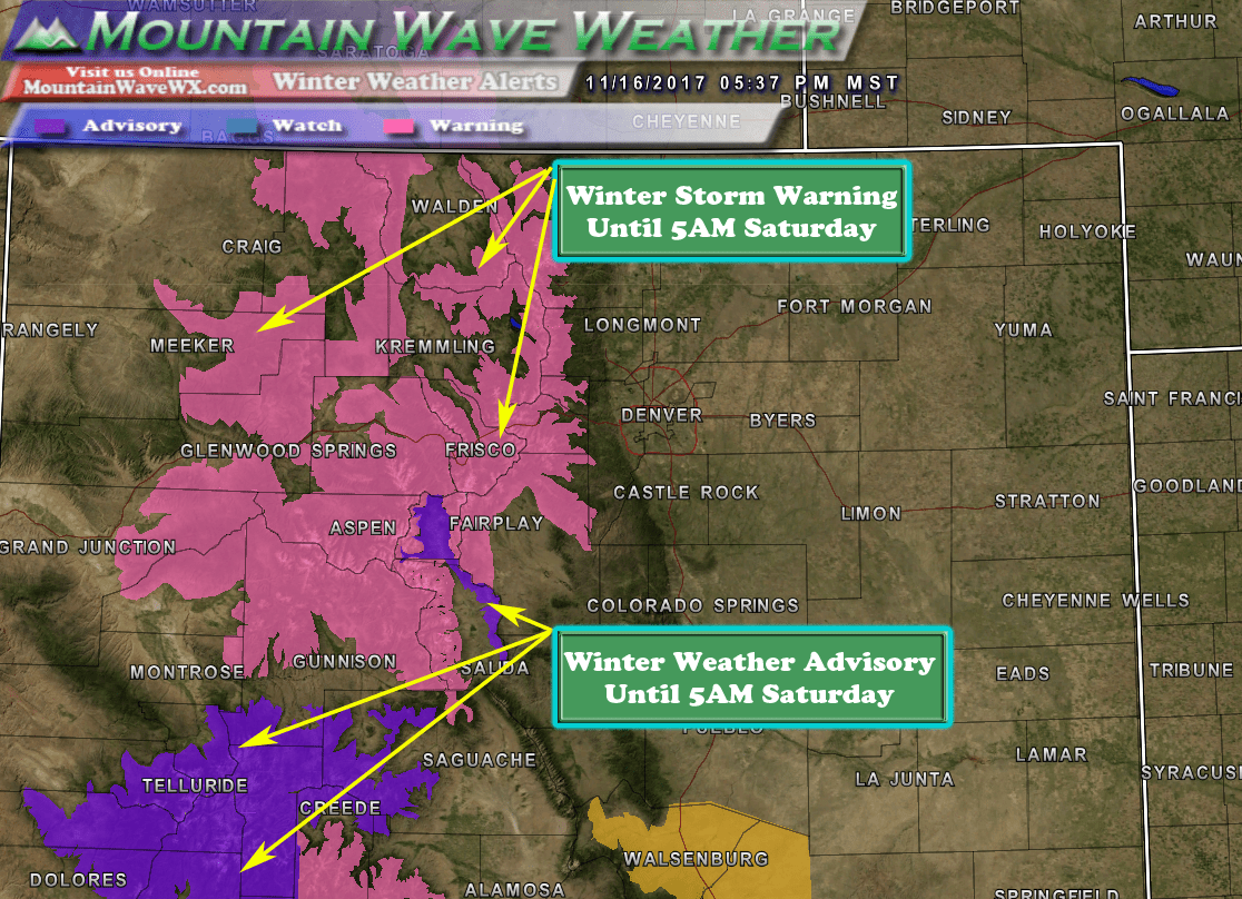
Additional Note About the Mountains
If you have any travel plans to the mountains this week, please keep a close eye on the forecast. Several storm systems are set to impact those areas and could cause treacherous travel conditions.
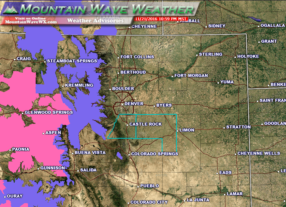
Winter Weather Warnings and Advisories are in effect for the mountains...
As of the time of this posting, here are the current winter weather statements for the mountains and their impacts:
***WINTER WEATHER ADVISORY***

INCLUDING THE CITIES OF EAST SLOPES PARK AND NORTHERN GORE
RANGES, GORE PASS, RABBIT EARS PASS, CAMERON PASS,
LARAMIE AND MEDICINE BOW MOUNTAINS, RABBIT EARS RANGE,
ROCKY MOUNTAIN NATIONAL PARK, WILLOW CREEK PASS, BERTHOUD PASS,
BRECKENRIDGE, EAST SLOPES MOSQUITO RANGE,
EAST SLOPES SOUTHERN GORE RANGE, EISENHOWER TUNNEL, INDIAN PEAKS,
KENOSHA MOUNTAINS, MOUNT EVANS, WILLIAMS FORK MOUNTAINS,
AND WINTER PARK
736 PM MST MON NOV 21 2016

...WINTER WEATHER ADVISORY REMAINS IN EFFECT UNTIL 5 PM MST
TUESDAY...

* TIMING...THROUGH TUESDAY AFTERNOON.

* SNOW ACCUMULATIONS...5 TO 10 INCHES...LOCALLY UP TO 1 FOOT.

* WIND/VISIBILITY...VISIBILITY WILL DROP TO A QUARTER MILE AT
  TIMES UNDER THE HEAVY SNOW SHOWERS OR BANDS.

* IMPACTS...ROADS ARE EXPECTED TO BECOME SNOW COVERED AND SLIPPERY
  THIS EVENING. HEAVIER SNOW SHOWERS OR BANDS WILL CREATE NEAR
  WHITEOUT CONDITIONS AT TIMES.

PRECAUTIONARY/PREPAREDNESS ACTIONS...

A WINTER WEATHER ADVISORY FOR SNOW MEANS THAT PERIODS OF SNOW
WILL CAUSE PRIMARILY TRAVEL DIFFICULTIES. BE PREPARED FOR SNOW
COVERED ROADS AND LIMITED VISIBILITIES...AND USE CAUTION WHILE
DRIVING.
***WINTER STORM WARNING***

...WINTER STORM WARNING REMAINS IN EFFECT UNTIL 6 PM MST TUESDAY
ABOVE 8500 FEET...

* LOCATIONS INCLUDE THE CITIES OF...VAIL...BUFORD...TRAPPERS
  LAKE.

* TIMING...THE HEAVIEST SNOWFALL IS EXPECTED TONIGHT AND TUESDAY.

* SNOW ACCUMULATION...6 TO 12 INCHES WITH LOCALLY HIGHER AMOUNTS.

* SNOW LEVEL...AROUND 9000 FEET... LOWERING TO MOUNTAIN BASES BY
  TUESDAY MORNING.

* WINDS...WEST 5 TO 15 MPH WITH GUSTS UP TO 30 MPH.

* IMPACTS...HEAVY SNOWFALL AND AREAS OF BLOWING SNOW WILL RESULT
  IN HAZARDOUS DRIVING CONDITIONS INCLUDING INTERSTATE 70 OVER
  VAIL PASS.

PRECAUTIONARY/PREPAREDNESS ACTIONS...

A WINTER STORM WARNING MEANS SIGNIFICANT AMOUNTS OF SNOW ARE
EXPECTED OR OCCURRING. STRONG WINDS AND BLOWING SNOW ARE ALSO
POSSIBLE. THIS WILL MAKE TRAVEL VERY HAZARDOUS OR IMPOSSIBLE.
We will be up early tracking this storm on Tuesday morning. Stay with us or your favorite local weather source for additional information about this storm.
