Latest Drought Update
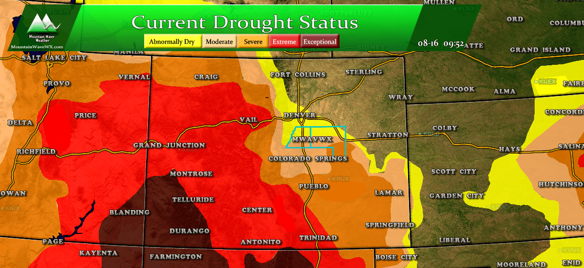
Current Colorado drought status as of 8/16/2018
The biggest change to Colorado's drought status for the week was the expansion of severe drought conditions across a good portion of Western Colorado to include many mountain areas. Many mountain areas have experienced above normal temperatures most of the summer and have been very dry. The expansion of the severe drought status is an indication that these areas are becoming quite parched as we move towards fall.
The National Drought Summary also mentioned, "According to August 12 USDA reports, 59% of the pasture and rangeland in Colorado was in poor to very poor condition, and 42% of the topsoil was short or very short of moisture."
Closer to Home
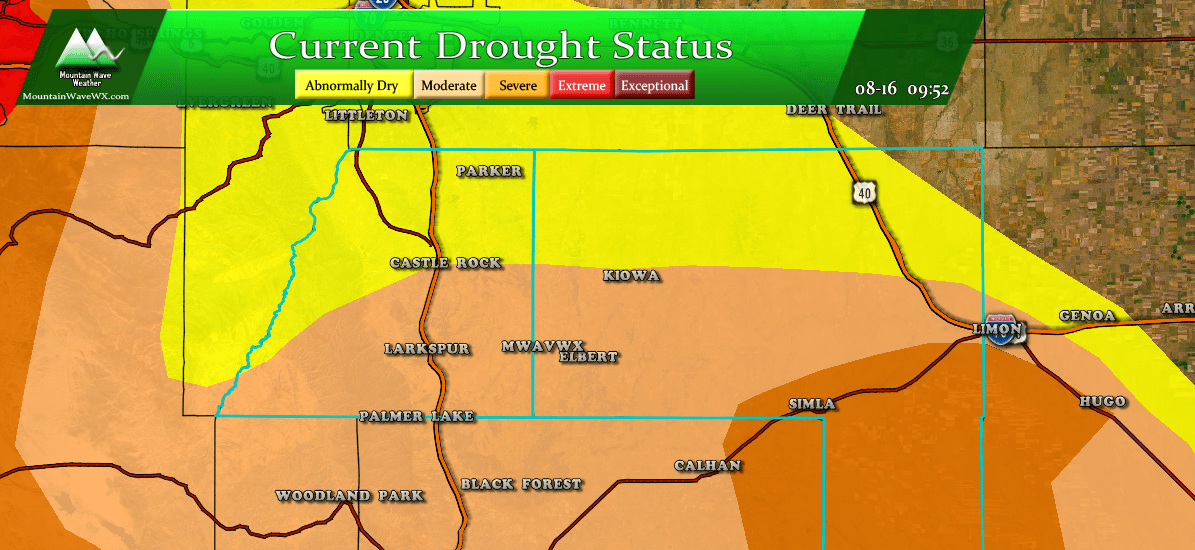
Palmer Divide region drought status as of 8/16/2018
Not much change from the past few weeks along the Palmer Divide. Most of the Northern sections remain abnormally dry with southern sections in the moderate drought classification. There are few areas in Southern and Eastern Elbert County that have made it into severe drought, but this hasn't changed in the past few weeks.
Why Are We Still in Drought?
Often folks have short memories when it comes to weather, the past few weeks most areas have seen rain fueled by the monsoon and some areas have seen quite a bit of it! The thing with drought is, it's not a short term problem and there are no quick ways to knock out drought.
Let's take a look at how July finished for precipitation in Castle Rock for example, when the monsoon started
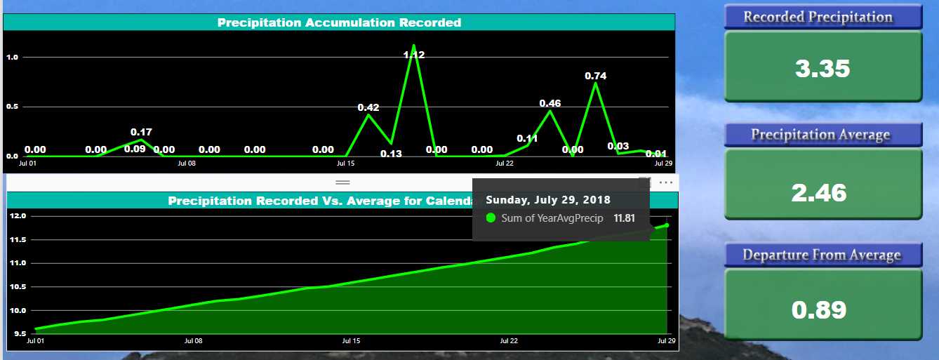 When you go back and look a the data, July finished just slightly above average for precipitation, we'd certainly qualify that as a "good" monsoon pattern as it brought beneficial rain across the Palmer Divide. Many areas ended up way above average, but that was only one month. Drought does not form or dissipate in a period of one month (except in very rare circumstances.)
So the month of July finished slightly above average, that's good! Let's zoom out a little bit and take a look at the three month period between May and June this year...
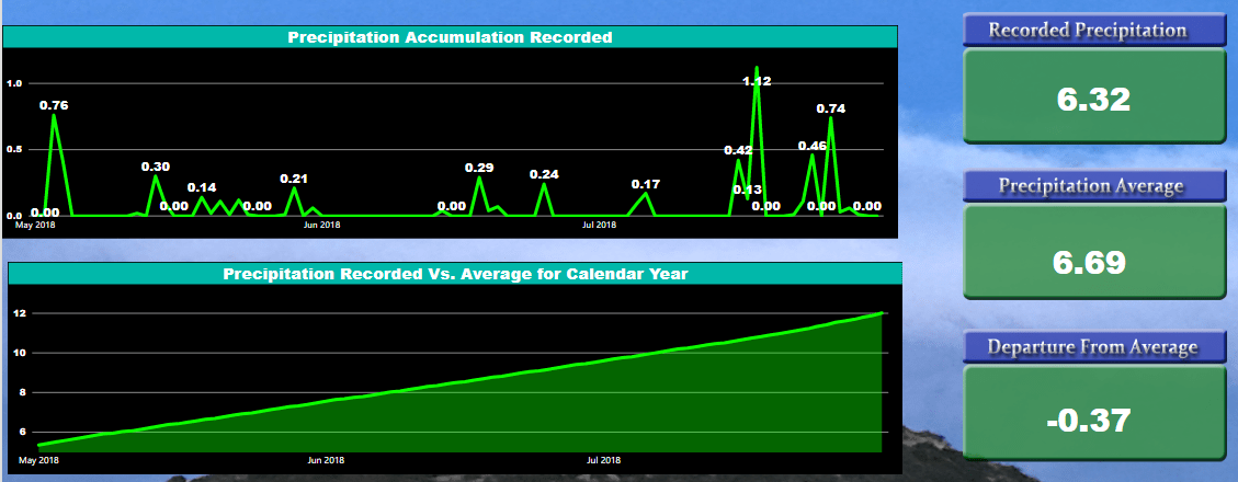
Precipitation stats for Castle Rock from May 1 - July 31, 2018
Not terrible but overall precipitation was just a tad below average... so whatever our drought status was at the time, we didn't receive enough to dent it but weren't dry enough for it to become too much worse.
If we zoom out just a bit more and look at the entire year the picture becomes a bit more clear. Castle Rock is over 2.5 inches below average for the year. This doesn't sound like much, but 2+ inches is a big deal. When you look back at the beginning of the year especially, you can see how dry our winter and spring were. Spring being one of our wet times of the year; if we fall behind in March and April, it is difficult to make that up for the rest of the year.
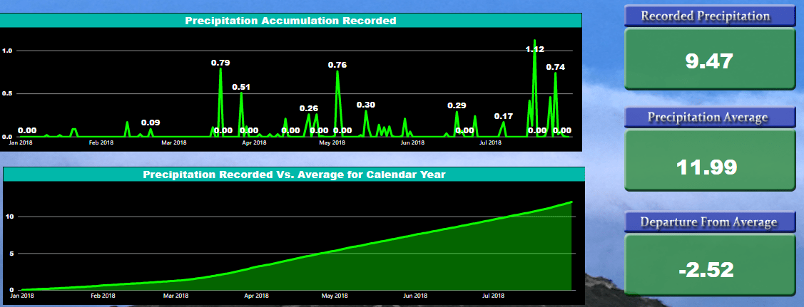
Castle Rock recorded precipitation vs. average from 1/1/2018 - 7/31/2018
Speaking of March and April, when we look purely at snowfall for snow year (September 1 - June 1), we can see more evidence of why we are still in drought status.
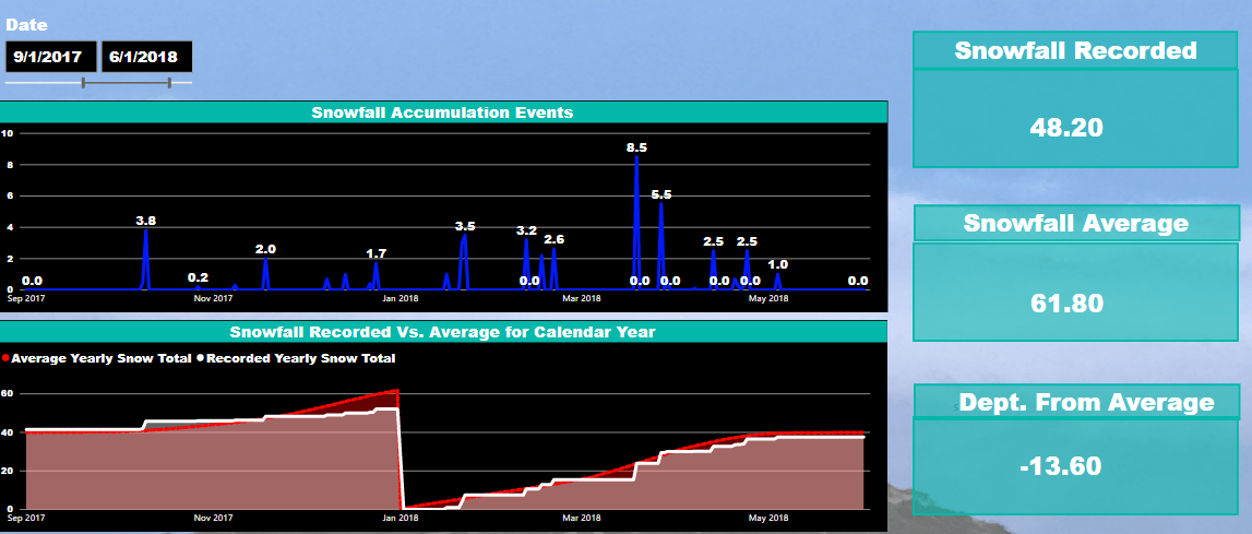
Snowfall statistics for Castle Rock from 2017-2018 snowfall season
Castle Rock was over 13 inches below average for snowfall last season. That combined with the overall lack of precipitation compounded our drought conditions and is a big reason why we are still seeing stress on vegetation, not to mention fires still going across the state.
By the way, for the snowfall season September 1, 2017 - June 1, 2018 Castle Rock was nearly 6 inches below average for precipitation. That is an enormous amount of missing water!
Any End In Sight?
Figuring out how long a drought will last is not an easy task, it requires a lot of long range forecasting and a bit of luck. With an El Nino pattern brewing for us going into fall and winter, there is reason to be optimistic about our chances of a wetter than average fall and winter.
This is whole topic in and of itself and will coincide with our long range forecast for the Palmer Divide (looking at fall and winter conditions expected for 2018-2019) Stay tuned for that and we will have more details on that and if we think our drought will be broken anytime soon.
Wrapping It All Up
So remember, drought is a long term weather phenomenon. There is no quick start or end, it's something that either builds or dissipates over a period of time. Our drought this year has been building since late 2017... with months and months of dryness a few weeks of rain in July is just enough to stop it from getting worse. It will take several months of above average precipitation to break us out of a drought, hopefully things pull together for us this fall!
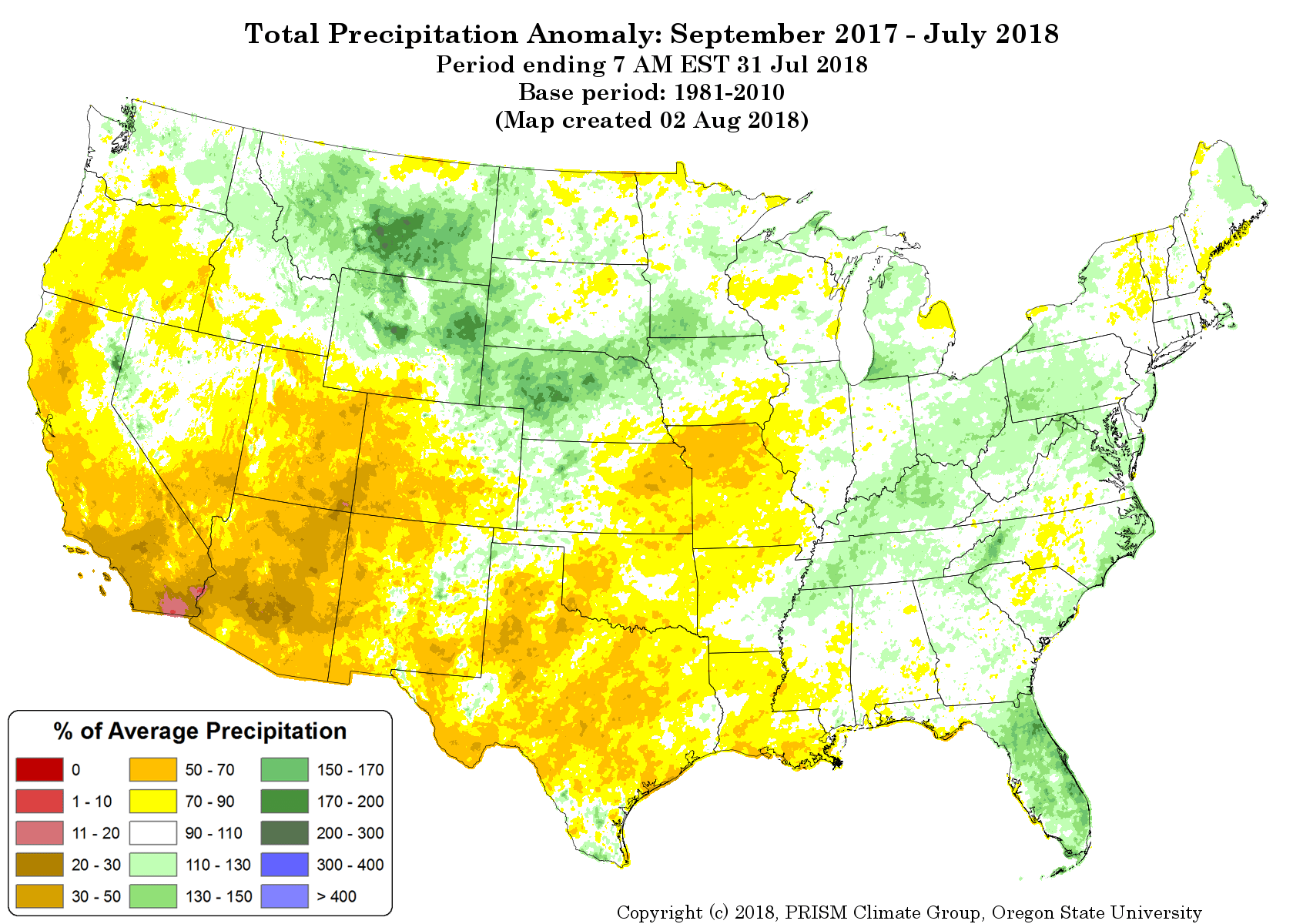
Precipitation anomaly for Sept 2018 - July 2018. You can see how the worst areas of drought follow along the driest areas on this map.
Don't forget to look at the big picture, July 2018 was quite wet, but overall for the past year we've seen many more abnormally dry months than abnormally wet months!
