Astronomical fall has finally arrived as of 1:50AM this morning and luckily for us it will start feeling a bit more like fall around here... after today. Monday looks to continue our trend of warm, above average temperatures but there are signs that the heat is coming to an end! Unfortunately, it has also been dry and while we see chances of moisture here and there in the medium range outlooks, not a whole lot of it looks too promising.
Temperatures
Temperatures overall will remain warm for the first part of the week so we will still continue to feel like summer for at least a little bit. We do see signs of a storm system dropping temperatures by the end of this week and towards the weekend. All eyes are on a stronger signal for cooler temperatures and possibly moisture going into the early/mid part of next week. Below is the forecast temperatures from the Euro model and is a pretty good representation of what you should expect in lower elevation areas of the Palmer Divide.
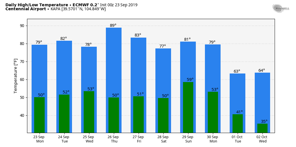
Centennial Airport Euro Model forecast temperatures through Weds. Oct. 2
The next graphic is for the Monument Hill area and is a good representation of the higher elevation areas of the Palmer Divide. As expected, temperatures at higher elevations will remain a bit cooler but keep a close eye on that system next week as we could see a period of freezing overnight temperatures in locations around or above 7,000 feet in elevation.
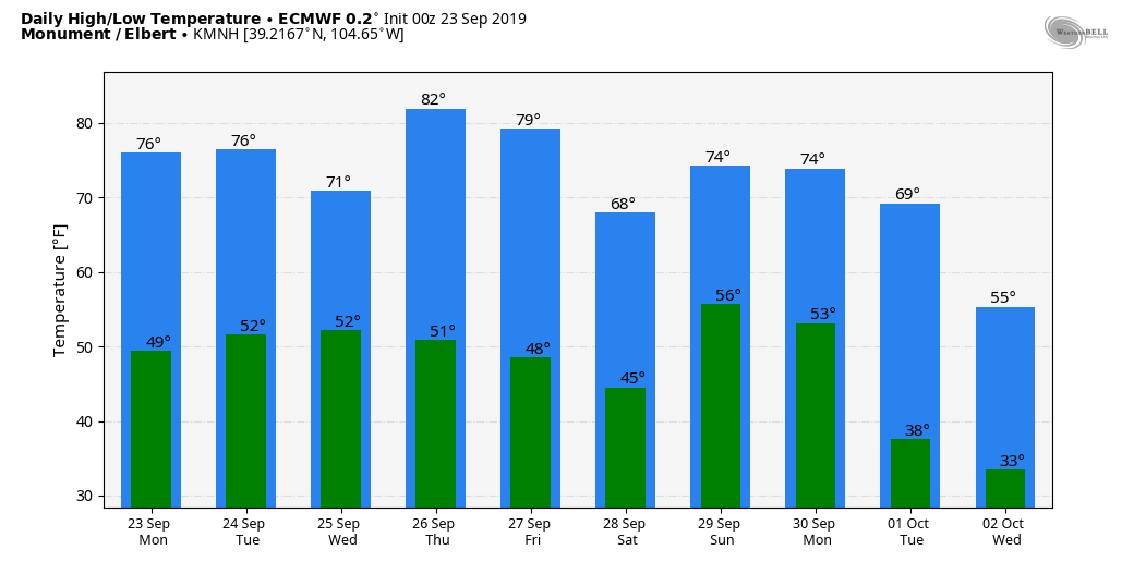
Monument Hill Euro Model forecast temperatures through Weds. Oct. 2
Precipitation... any snow in the forecast?
Unfortunately the moisture situation doesn't look stellar over the next 7-10 days for especially the Eastern part of the state. That doesn't mean we will see absolutely nothing, it just means that whatever we do see looks pretty hit or miss and not a whole lot of quantity of moisture.
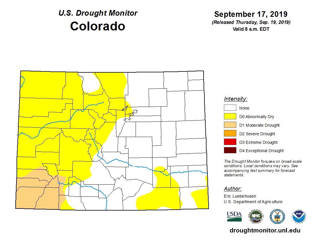
Drought conditions are slowly beginning to return to Colorado with mainly the mountain areas and Southwest part of the state seeing the biggest effects. That said, if conditions verify as I expect them too, I wouldn't be surprised to see some of these drought conditions expanding Eastward to the front range and along the Palmer Divide in the near future.
The thing to remember is that September is generally a dry month, so the fact that we've been dry for the past few weeks is not unusual in and of itself. What doesn't help is the crazy heat we've had to deal with... more on that later but September could go down in the history books as the warmest September on record for Colorado.
As far as moisture, let's take a look at some models...
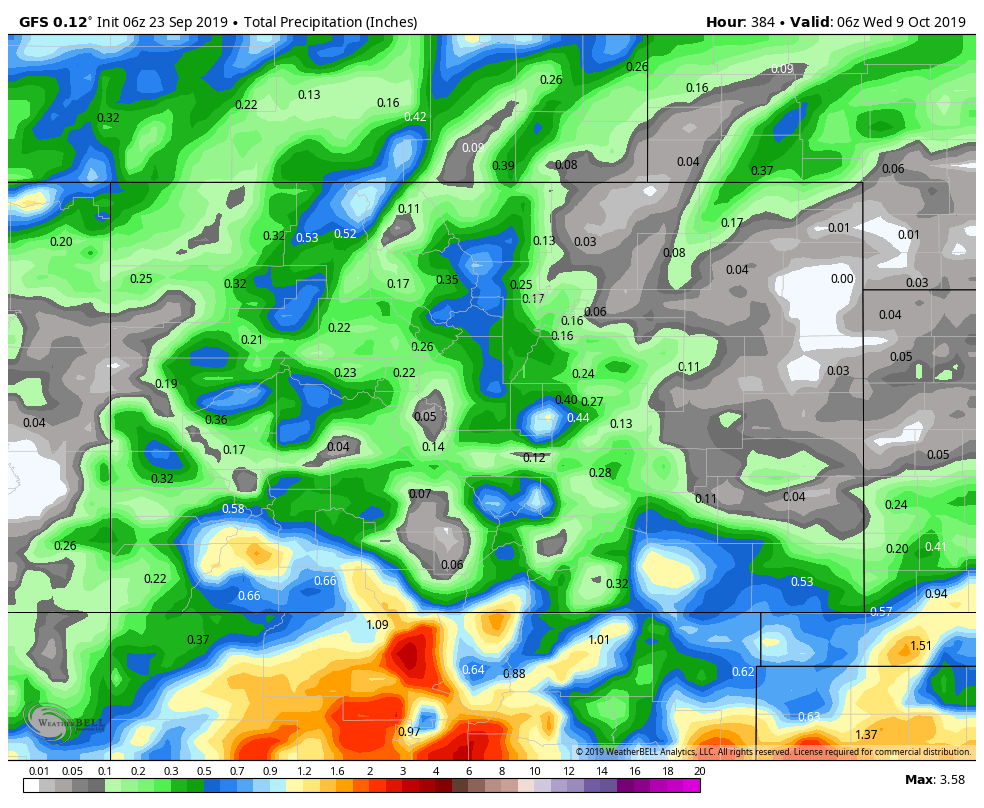
GFS total precip for next 10 days
Above is the GFS precipitation expected through Wednesday October 9 and as always since this is a longer range look don't get hung up on exact numbers and locations. Instead look at the higher level pattern the model shows; moisture right up along the continental divide with some chances for moisture in the mountain areas as well. Southwestern Colorado may benefit from decent moisture which will help out their drought situation, at least a little bit. The most concerning thing is the dry signal East of the Divide...
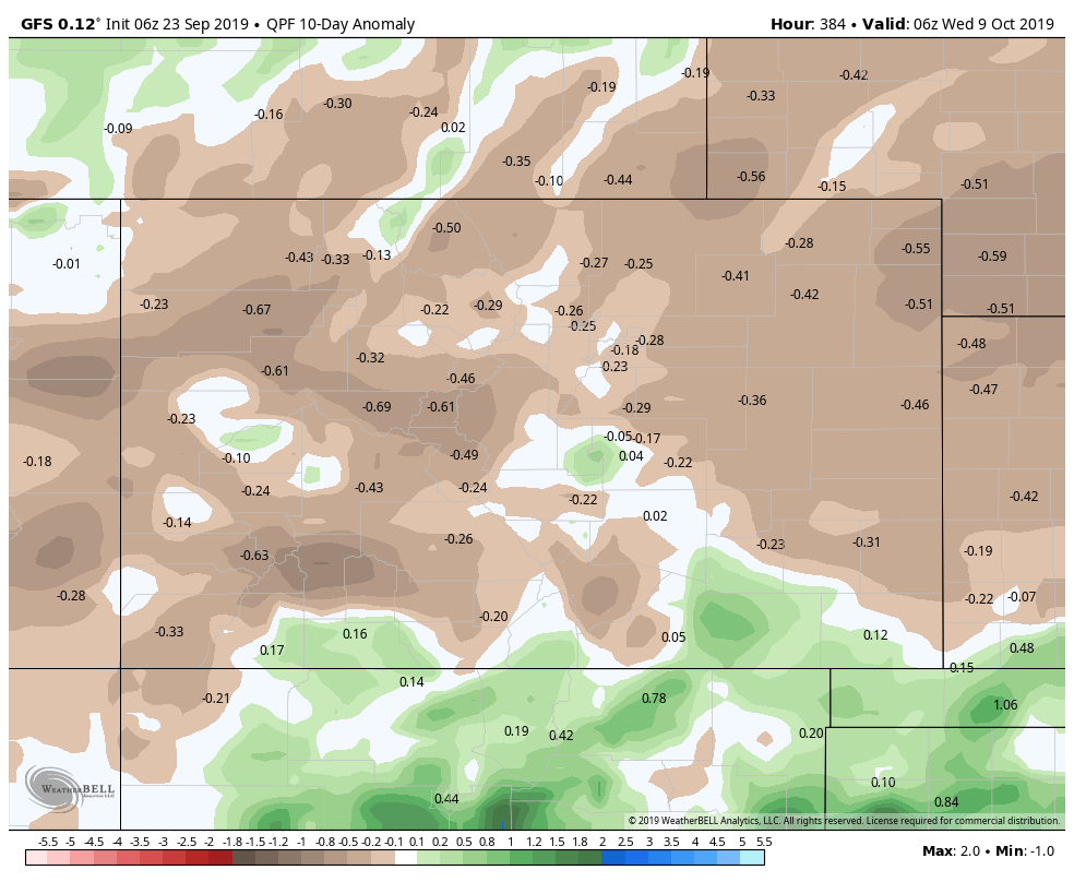
GFS precipitation anamoly for next 10 days
In fact, in the 10 day anomalies you can see most of the state will end up below normal, even though there will be chances for moisture it won't be enough to keep us around average. This graphic basically means that even though we recieve some chances of moisture in the next 10 days, if you take that amount and put it up against the average (what we normally see over the next 10 day period) we will end up below average.
And this signal doesn't just show up on the GFS... the Euro is similarly dry for the next few days as well and especially with drier conditions East of the divide.
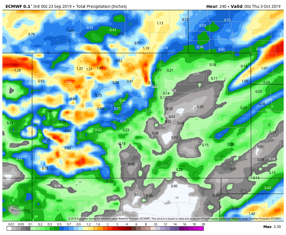
Euro total precip for next 10 days
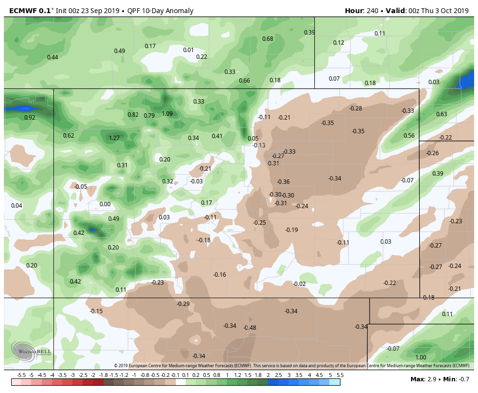
Euro precipitation anomaly for next 10 days
Summary
So what should you expect over the next 7-10 days? Expect a week of fall in Colorado; you will see everything from near record-setting heat to days that barely break the 70's. We like to call it the roller coaster!
From a precipitation standpoint, really the best shot looks like next monday-wednesday timeframe. I want to caution that since that is more than 7 days out at this point, take it with a grain of salt and just keep an eye out for forecast updates. Yes, it would be cold enough to snow at higher elevations over the Palmer Divide in the night-time hours but I won't get too excited about it until I get better evidence that this storm system lines up and produces moisture first.
So not yet calling for the first snow down here... but keeping a close eye on early to mid next week!
