Another storm system and a couple of cold fronts will move into the area beginning late Sunday night and into Monday morning, the big story on Monday will be the temperature shock and the chance for freezing fog and maybe even a bit of freezing rain!
Monday Morning -- Ice Will be a Concern
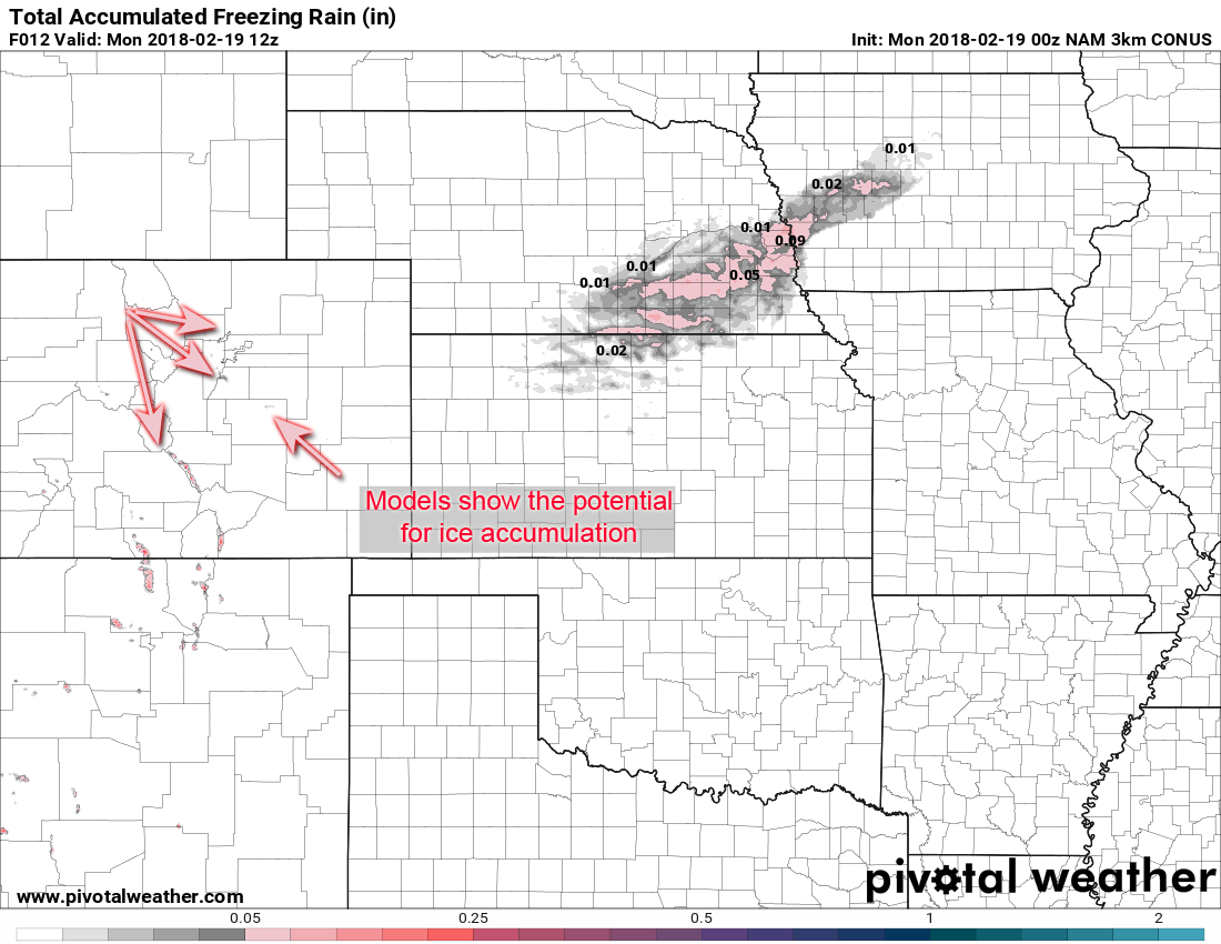
Some models are picking up ice accumulations in a few areas, this will have to be watched closely for Monday morning.
Models are picking up on the potential for ice accumulation for some areas of the front range. In the NAM3K model to the left, don't focus on the exact areas so much. Focus more on the fact that ice accumulation is possible in some areas.
As a cold front sweeps across the area Sunday night, a layer of shallow moisture and much colder temperatures will condense to form fog. Since temperatures will drop below freezing, fog and any precipitation could possibly freeze to create ice.
This is something we will need to watch closely but expect the potential for travel impacts Monday morning for areas that see ice.
Monday Evening -- Shot of Snow and Travel Impacts Possible
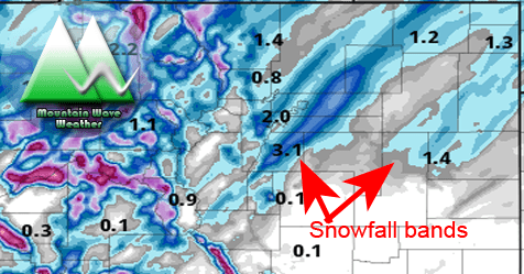
Nam3k shows banded snowfall pushing onto the plains sometime after 3pm. We will have to watch this closely to see if it will impact Monday evening commute!
As we continue through the day Monday, a reinforcing shot of cold air will push across the mountains and onto the plains. Notice the bands of snowfall predicted by the Nam3K model on the right, this is a snapshot of what this model thinks things will look like right around 5pm.
The issue here is snow looks to start sometime around the rush hour (maybe at the tail end, we'll wait for more detials) and persist through the evening and into the nighttime hours. This could cause travel difficulties for any folks caught under these snow bands.
Remember, snow can fall with moderate to heavy intensity under snowfall bands and cause road conditions to quickly deteriorate!
Long story short; we will need to keep a close eye on model and forecast data during the day Monday to see how this evolves. For now, count on the possibility of a rough commute on Monday evening.
Storm Snowfall Totals and Impacts
Anytime you see models showing banded snowfall it introduces uncertainty to snowfall forecasts. The reason for this is that while models are great at showing a storm will have banded snowfall, they're not great at showing exactly where they end up. Since snowfall can be intense under these bands areas under them tend to over perform on snow while areas just 5-10 miles away from them may see no snow at all. The best way to forecast snowfall in cases like these is to look at probabilities, or the most likely ranges for snowfall and tailor a forecast around those numbers.
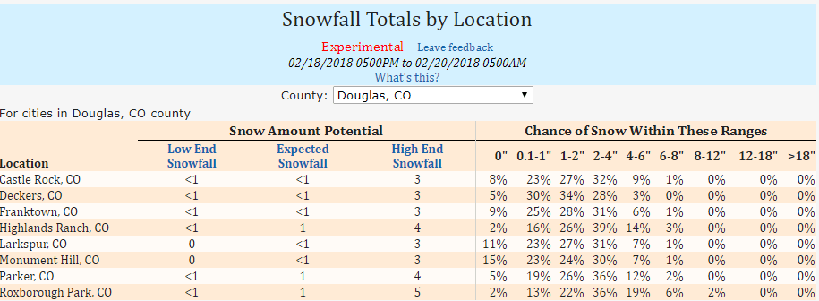
If you look at a place like Castle Rock you see the highest probability is that snowfall will end up between 0 and 4 inches. We can use this combined with that the models are showing to make a forecast. Similarly we can look at snowfall probabilities for areas in Elbert County:
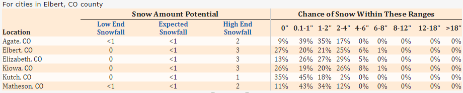
You can see similarities for places in Elbert County but notice how much higher the chances are at receiving 0 inches of snow area. This is something to consider because most locations in Elbert County are further away from upslope along the front range and the Northern bias the models are showing with this storm verifies these numbers a bit more as well.
So with that, here are the most likely total storm snowfall accumulation ranges with the data we have as of tonight:
Castle Rock: 0-3 inches
Highlands Ranch: 1-4 inches
Franktown: 1-4 inches (terrain helps upslope a bit here!)
Parker: 1-4 inches
Elbert: 0-3 inches
Elizabeth: 0-3 inches
Kiowa: 0-3 inches
**Don't forget the higher chance of no accumulation for areas in Elbert County!
Summary
That's a wrap for this forecast analysis! Monday is going to be an unsettled day with a chance of freezing precip in the morning and snow in the evening. Keep a close eye on the potential for travel impacts especially if snow bands set up along the Palmer Divide or Tech Center of Denver on Monday evening.
We will keep an eye on things Monday and pass along any updates as needed. Have a great Sunday evening!

Thanks John R. Braddock!Totally helps!Lori