Current Weather Watches/Warnings/Advisories
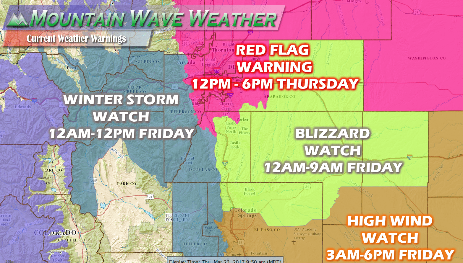
Weather Advisories as of 10AM
- Red Flag Warning (12PM - 6PM) Thursday
- Includes all of Eastern and Northeastern Colorado
- A Red Flag Warning means that critical fire weather conditions are either occurring now....or will shortly. A combination of strong winds...low relative humidity...and warm temperatures can contribute to extreme fire behavior.
- Blizzard Watch (12AM - 9AM Friday)
- Includes Palmer Divide region: Douglas County above 6,000ft elevation, Elbert County, Lincoln County
- Castle Rock, Larkspur, Elbert, Limon, Elizabeth, Kiowa, Franktown, Monument are all included in the Blizzard Watch
- A Blizzard Watch means there is a potential for falling and/or blowing snow with strong winds and extremely poor visibilities. This can lead to whiteout conditions and make travel very dangerous.
- Winter Storm Watch (12AM - 12PM Friday)
- Western Douglas County foothills, foothills west of Denver, extreme Western Palmer Divide region, continental divide region mountains.
- A Winter Storm Watch means there is a potential for significant snow...sleet...or ice accumulations that may impact travel. Continue to monitor the latest forecasts.
What To Expect With This Storm in and Around the Palmer Divide
This specifically means what to expect in Castle Rock, Larskspur, Franktown, Elizabeth, Kiowa, Monument and surrounding areas out towards Limon.
Timing
- Expect windy conditions throughout the day Thursday beginning after 12PM. This will mean increased fire danger and strong winds that may affect high profile vehicles on the highways.
- Precipitation begins as rain moving into the area late tonight (models generally show this starting after 9PM)
- Transition to all snow sometime around midnight
- Heavy snow and strong winds will create blizzard conditions along the Palmer Divide from midnight to Friday morning
- The storm should begin to move out by late Friday morning into Friday afternoon.
Snow Accumulations
- Castle Rock and Northern Palmer Divide can expect 6-12 inches total accumulation by Friday afternoon
- Castle Rock, Pinery, Franktown, Elizabeth, Kiowa
- Areas over and near Monument hill can expect 7-14 inches of accumulation
- Larkspur, Palmer Lake, Monument, Black Forest
- Localized amounts of 8-16 inches will be possible
Wind/Visibility
- Strong northerly and northwesterly winds will make for blowing and drifting snow
- Visibility could drop below 1/4 mile in wind-prone areas
Impacts
- Heavy snow, especially after midnight into the early morning hours of Friday will make travel difficult. Road closures will be possible in some areas.
- Roads are expected to become icy and snowpacked
- Nonessential travel is not recommended after midnight in the Palmer Divide region.
Summary
At the end of the day folks, this storm is a quick hitter. It will be at its worst while most of us are sleeping and will make for a very nasty Friday morning commute. It doesn't warrant a trip to the store as the roads should be in much better shape by Friday afternoon and evening. The snow will be very heavy at times from midnight to 9AM so keep that in mind.
If you are travelling back to the area from spring break, expect tricky travel conditions through the day Friday especially if you are coming back from the South or West. I-25 through Monument Hill will be treacherous during the day and I-70 near the divide (Eisenhower Tunnel) could be tricky as well.
As the storm moves out Friday I'd expect better road conditions later in the day and much improved travel conditions through the region on Saturday, so consider that if you are travelling and can flex your times a bit.
Quick Note
To all of the folks asking questions and interacting on my facebook page or website, thank you! I'm always happy to discuss weather or give you information if you have travel plans or concerns about the weather, just let me know!
Mountain Wave Weather Resources
Stay up to date with our weather information below:
-
Severe Weather Watches/Warnings/Advisories by Mountain Wave Weather
- Custom tailored weather alerts for Castle Rock and the Palmer Divide Region piped in straight from the National Weather Service
-
Significant Weather Page for Palmer Divide Region by Mountain Wave Weather
- Up-to-date forecast information for significant weather events in and around Castle Rock from NWS
-
Real-Time Weather Dashboard for Castle Rock Colorado
- Data straight from our weather station in Castle Rock. Phone apps and TV stations get their data from Centennial Airport, not us!
Thanks for following along and we will have more updates through the day as needed!


Trackbacks/Pingbacks